


1861 Map of Lower and Upper Canada. By Johnson and Browning
0 Sold
Similar Sale HistoryUnlock All Sale Prices
Sold
Sold
Sold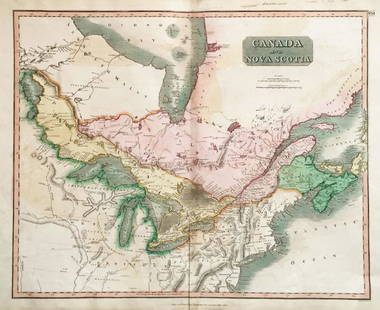
Sold
Sold
Sold
Sold
Sold
Sold
Sold
Sold
Sold
Sold
Sold
Sold
Sold
Sold
Sold
Sold
Sold
Sold
Sold
Sold
Upcoming SalesView All


![Wyoming History (3) 1899 & 1955 Reprints [182275] (1 of 3)](https://p1.liveauctioneers.com/2699/331494/178785555_1_x.jpg?height=282&quality=70&version=1717094654)
![Across America, Rusling, 1875 [181941] (1 of 9)](https://p1.liveauctioneers.com/2699/331494/178785461_1_x.jpg?height=282&quality=70&version=1717189774)


![Heart of the Alleghanies Book c1883 [181016] (1 of 7)](https://p1.liveauctioneers.com/2699/331494/178785458_1_x.jpg?height=282&quality=70&version=1717107891)
![Canadian Pacific RWY Co Pass 1924 [180522] (1 of 2)](https://p1.liveauctioneers.com/2699/331495/178785855_1_x.jpg?height=282&quality=70&version=1717094933)
![Indian Territory Map by Donaldson, 1883 [181628] (1 of 1)](https://p1.liveauctioneers.com/2699/331495/178785757_1_x.jpg?height=282&quality=70&version=1717094933)


![Life of Sitting Bull, Indian War, 1891 [182047] (1 of 5)](https://p1.liveauctioneers.com/2699/331494/178785305_1_x.jpg?height=282&quality=70&version=1717094654)

![Foreign Interest Books c1863-1906 (4) [179682] (1 of 9)](https://p1.liveauctioneers.com/2699/331494/178785475_1_x.jpg?height=282&quality=70&version=1717094654)


Related Searches
TOP