Sold2017Cary: Antique Map of Upper & Lower Canada, 1807Map: A New Map of Upper & Lower Canada Cartographer: John Cary Place & Date: London / 1807 Size: 20 1/4" x 18" Condition: original color; light overall age toning; a repaired nick in the edge of the uSee Sold Price
Sold20191798 Hand Colored Map of Upper & Lower Canada1798 hand colored map of upper and lower Canada, published in London by J. Storkdale of Piccadilly. Rough edges and some foxing. Unframed. Measures approximately 8-1/4" in height by 10-1/4" in width.See Sold Price
Sold2021United States With Upper & Lower CanadaPublication Date: 1850Title: United States With Upper & Lower Canada Cartographer: CRUCHLEY, G.F. Publisher: CRUCHLEY, G.F. Height: 17.5 Width: 13.8 Shows U.S. just past the first tier of states w. ofSee Sold Price
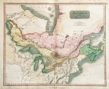
Sold2018Thomson: Upper & Lower Canada, Nova ScotiaMap: Canada and Nova Scotia Cartographer: Thomson Place/Date: Edinburgh / 1814/1817 Size: 23 3/4" x 19 1/8" Condition: wash color; light browning along centerfold and in margins; some staining in uppeSee Sold Price
Sold2022(UNITED STATES - REPUBLIC OF TEXAS.) James Wyld. Map of the United States and the Provinces of Upper(UNITED STATES - REPUBLIC OF TEXAS.) James Wyld. Map of the United States and the Provinces of Upper & Lower Canada, New Brunswick, and Nova Scotia, Compiled from the Latest Surveys and Other AuthentiSee Sold Price
Sold2019CanadaTitle: Canada Publication Date: 1829 Cartographer: Anthony Finley Publisher: Anthony FinleySize: 8.5Height - 11.5Width Details Upper & Lower Canada. From: "A New General Atlas... of the Globe..." ShowSee Sold Price
Sold2016Framed and matted map of Upper and Lower Canada datedFramed and matted map of Upper and Lower Canada dated 1798, published in 1798 by J. Stockdale. Site-7.25"h.x9.5"w.See Sold Price
Sold2019Upper and lower CanadaTitle/Content of Map: Upper and lower Canada Date 1863 Cartographer: By Johnson & Ward. From, Johnson’s New Illustrated Family Atlas Size: 18x26” Provenance: New York. Hand colored. Text on verso.See Sold Price
Sold20191ST EDITION / 1ÈRE EDITION, ISAAC WELD, D. 1799A First Edition of Isaac Weld's (B. 1774-1856), "Travels through the states of North America and the provinces of Upper and Lower Canada, 1795, 1796, and 1797", featuring a folding map with coloured oSee Sold Price
Sold2016Weld's Travels Through North America 1799Heading: Author: Weld, Isaac Title: Travels Through the States of North America, and the Provinces of Upper and Lower Canada, During the Years 1795, 1796, and 1797 Place Published: London Publisher:JSee Sold Price
Sold2016Geographical, Statistical & Historical Map Canada, 1823Map: Geographical, Statistical and Historical Map of Upper and Lower Canada, and the other British Possessions in North America Cartographer: F. Lucas Publishing: Philadelphia / Baltimore, 1823 Size:See Sold Price
Sold2020[CIVIL WAR] Cruchley, G. 1 map[Civil War]. Cruchley, G. F. UNITED STATES WITH UPPER AND LOWER CANADA. London, [c.1860s]. Engraved map, hand coloured. 44cm x 35.3cm (17.25" x 14") black line 46.8cm x 37cm (18.5" x 14.5") sheet A faSee Sold Price
Sold2019Carey & Lea: British North AmericaReserve Reduced! Map Title: British Possessions in North America Cartographer: Carey & Lea Place/Date: London / 1823 Size: 9 1/2" x 7 1/2" Condition: outline color; Upper and Lower Canada and the MariSee Sold Price
Sold2022Antique Map - Map of North America - Canada - Toronto - Montreal - William HugheAn interesting mid 19th century map of Upper and Lower Canada - with an inset of New Brunswick and Nova Scotia - which appeared in Barclay's Universal English Dictionary (London: George Virtue, 1840s)See Sold Price
Sold2023[UPPER CANADA] THE LOWER CANADA WATCHMAN. 1829THE LOWER CANADA WATCHMAN: Kingston: James Macfarlane, 1829. 12mo. Brown paper boards backed in grey cloth. Title in paper label on spine. All edges speckled brown. Generally very good condition: boarSee Sold Price
Sold2019Meyer: Upper Canada (Ontario) / Lower Canada (Quebec)Map Title: Ober (Upper) Canada 1849 / Unter (Lower) Canada 1849 Cartographer: Bibliographischen Instituts. Place/Date: Hildburghausen / 1849/1857 Size: 14 5/8" x 11 3/4" Condition: original outline coSee Sold Price
Sold20221850s map of British North America, W & R ChambersEngraved map titled “Principal British Possessions in North America.” Nova Scotia, New Brunswick, Lower Canada and Upper Canada are marked in original outline hand color. Above this stretcSee Sold Price
20231861 Map of Lower and Upper Canada. By Johnson and BrowningTitle: 1861 Map of Lower and Upper Canada. By Johnson and Browning Date/Period: 1861 Materials: Steel engravedSize: 26 x 18” 1861, by Johnson and Browning. From ‘New Illustrated Family AtlSee Sold Price
Sold2021Three Volumes of British America, 1839"A Historical and Descriptive Account of British America, Comprehending Canada Upper and Lower, Novia Scotia...". Oliver and Boyd, Edinburgh 1839. First edition. In three volumes with engraved title pSee Sold Price
Sold2023SMYTH GAZETTEER OF UPPER CANADA 1813Smyth, David WilliamGAZETTEER OF THE PROVINCE OF UPPER CANADA: to which is added an appendix, describing the principal towns, fortifications and rivers in Lower Canada. New York: Prior and Dunning, 18See Sold Price
Sold2024IGNACE FRANCOIS RANVOYZE 18th C SILVER TUMBLER CUPQuebec City, Lower Canada, late 18th C Raised from a heavy gauge of silver this example is a typical French form with a thick top edge embellished with turned bands, period initials tothe upper body MSee Sold Price
Sold2024SAMPLERAn alphabet and numbers sampler by Mary Bailey from Lower Canada, dated 1830. Some staining to the upper portions of the sampler. 11 1/2" H, 13 1/2" W.See Sold Price
Sold2024Collection of Canadian Bank and Commerce TokensCollection of 13 Canadian Bank and Commerce Tokens including Upper Canada, Nova Scotia, Ships, Colonies & Commerce, Montreal, Wellington (Lower Canada) and New Brunswick. Mixed grades.See Sold Price
Sold2016Canada: Copper Coin AssortmentCanada: Copper Coin Assortment Including (3) 1837 2 Sous from lower Canada; 1850, (3) 1852, (2) 1854 and (4) 1857 1c from Upper Canada Category: World Coins & Currency > World Coins Shipping Status: LSee Sold Price
3 days LeftHolabird Western Americana CollectionsWyoming History (3) 1899 & 1955 Reprints [182275]$200
Jun 13Swann Auction Galleries(CANADA.) Thomas Jefferys. A Large and Particular Plan of Shegnekto Bay, and the Circumjacent$1,100
2 days LeftJasper52NILE VALLEY. Upper & Lower. Egypt Sinai Nubia Sudan Abyssinia. BLACKIE 1886 map$20
5 days LeftHolabird Western Americana CollectionsGold & Silver Metallurgy (2) 1896, 1904 [182279]$100
Jun 14DuMouchellesAntique International Small Coins, Feat. French, Canadian, British & Spanish, 1828-1907$50
3 days LeftHolabird Western Americana CollectionsBureau American Ethnology 22nd Report, 1904 [182511]$75


![[CIVIL WAR] Cruchley, G. 1 map: [Civil War]. Cruchley, G. F. UNITED STATES WITH UPPER AND LOWER CANADA. London, [c.1860s]. Engraved map, hand coloured. 44cm x 35.3cm (17.25" x 14") black line 46.8cm x 37cm (18.5" x 14.5") sheet A fa](https://p1.liveauctioneers.com/1124/187577/94368859_1_x.jpg?height=310&quality=70&version=1607095126)


![[UPPER CANADA] THE LOWER CANADA WATCHMAN. 1829: THE LOWER CANADA WATCHMAN: Kingston: James Macfarlane, 1829. 12mo. Brown paper boards backed in grey cloth. Title in paper label on spine. All edges speckled brown. Generally very good condition: boar](https://p1.liveauctioneers.com/8124/283183/149424766_1_x.jpg?height=310&quality=70&version=1679790999)


![Wyoming History (3) 1899 & 1955 Reprints [182275] (1 of 3)](https://p1.liveauctioneers.com/2699/331494/178785555_1_x.jpg?height=282&quality=70&version=1717094654)


![Canadian Pacific RWY Co Pass 1924 [180522] (1 of 2)](https://p1.liveauctioneers.com/2699/331495/178785855_1_x.jpg?height=282&quality=70&version=1717094933)


![History of Utah, Bancroft, 1890 [182273] (1 of 3)](https://p1.liveauctioneers.com/2699/331494/178785554_1_x.jpg?height=282&quality=70&version=1717094654)


![Natural Wealth of California Book c1868 [181336] (1 of 3)](https://p1.liveauctioneers.com/2699/331494/178785588_1_x.jpg?height=282&quality=70&version=1717094654)


![Colorado Gold Rush Book Collection (6) [181922] (1 of 9)](https://p1.liveauctioneers.com/2699/331494/178785590_1_x.jpg?height=282&quality=70&version=1717094654)
![Gold & Silver Metallurgy (2) 1896, 1904 [182279] (1 of 14)](https://p1.liveauctioneers.com/2699/331499/178846306_1_x.jpg?height=282&quality=70&version=1717095214)


![Bureau American Ethnology 22nd Report, 1904 [182511] (1 of 16)](https://p1.liveauctioneers.com/2699/331494/178785292_1_x.jpg?height=282&quality=70&version=1717189774)
![Across America, Rusling, 1875 [181941] (1 of 9)](https://p1.liveauctioneers.com/2699/331494/178785461_1_x.jpg?height=282&quality=70&version=1717189774)
![Ore Analysis Books (2) 1913, 33 [182282] (1 of 7)](https://p1.liveauctioneers.com/2699/331499/178846290_1_x.jpg?height=282&quality=70&version=1717095214)