Sold20201749 Land Grant & Kearns Golden's Bridge MapsHenry Brown, Patent to 790 Acres of Land in Surry, (Sussex?) County 1749. Together with 8 renditions, 6 Edward J Kearns 1976 Map of Golden's Bridge. All numbered from the edition of 300, one signed inSee Sold Price
Sold2022Northern Pacific Land Grant Montana Map c. 1890Featured in this lot is this Northern Pacific land grant Montana Map circa 1890. The map features the plot map of part of Montana and reads as follows: Map Showing Northern Pacific Land Grant in partSee Sold Price
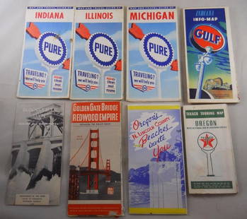
Sold2018Grouping of vintage gas station road maps and travelPure, Gulf, Texaco Maps. Golden Gate Bridge, N. Lincoln, Bonneville Dam – 8 pcs. Total.See Sold Price
Sold2023Framed Map of Spanish & Mexican Land Grants for King RanchFramed and glazed colored map depicting the coastal area between the Rio Grande and The Nueces, showing early Spanish and Mexican land grants for King Ranch as of 1852 We happily provide seamless shiSee Sold Price
Sold2017Map of French & English Grants Lake ChamplainMap of French & English land grants on Lake Champlain. Engraved and published by Rich H Pease Albany. 22" x 14"See Sold Price
Sold2022Map of French and English Grants on Lake ChamplainFramed hand colored cadastral map of French and English land grants in the Champlain valley, names of property owners and boundaries. Engraved by Richard H. Pease (1813-1869), authored by Edmund BaileSee Sold Price
Sold2022[WEST FLORIDA] CHESTER, PETER. Three crudely printed land grants for West Florida, each engrossed in[WEST FLORIDA] CHESTER, PETER. Three crudely printed land grants for West Florida, each engrossed in manuscript, with an attached manuscript survey map. Pensacola, Florida, 1st September, 1777; 24 NovSee Sold Price
Sold2022[WEST FLORIDA] CHESTER, PETER. Three crudely printed land grants for West Florida, engrossed in[WEST FLORIDA] CHESTER, PETER. Three crudely printed land grants for West Florida, engrossed in manuscript, each with an attached manuscript survey map. Pensacola, Florida: 11 January, 14 November andSee Sold Price
Sold2021Early Map of Bexar County, TXEarly map of Bexar County, TX, showing original land grants, framed frame: 30"h x 34"w Provenance: A San Antonio, TX Collection We happily provide seamless shipping services on everything we sell.See Sold Price
Sold2019Antique Map US Rail Roads and Wagon Roads"Map of the Untied States showing the Limits Within Which Land Grants were Made by the Federal Government to Aid in the Construction of Railroads and Wagon Roads". Engraved and printed for the 9th CenSee Sold Price
Sold2024Vntg Town Of Lewisboro NY Illustrated. Geographical MapVintage silk screen of a colored geographical map of the Town of Lewisboro Westchester NY. Showing sections of Goldens bridge, Cross River and South Salem. From the cross river business advertising DiSee Sold Price
Sold20221879 Powell Map of US with Railroad Grants -- Map of the United States Exhibiting the Grants ofTitle: 1879 Powell Map of US with Railroad Grants -- Map of the United States Exhibiting the Grants of Lands Made by the General Government to Aid the Construction of Railroads and Wagon Roads. CartogSee Sold Price
Sold2019Original Mixed Media Art [Golden Gate Bridge]A fine original watercolor with gouache painting titled 'Golden Gate Bridge,' circa 1950, verso of frame. Measures 8.5 in. x 7 in. sight size 13.25 in. x 11.25 in. Framed measuring 13.375-in. x 11.375See Sold Price
Sold2024Richard Danskin Original Oil on Board [Trolley]Richard Danskin (American, 20th Century) original oil on board. Trolley car with the Golden Gate Bridge in the background. Site size measures 6.5 in. x 4.5 in. and the frame measures 15 in. x 13 in. xSee Sold Price
Sold2018WPA San Francisco Scenes By JOHN G NEWBERRY 1944Watercolors. One is depicting Russian Hill & The Golden Gate Bridge. The other depicts Russ Building Grant & California Streets. Both were done in 1944. 26 1/2 x 20 3/4 in. (Framed), 19 1/2 x 14 in. (See Sold Price
Sold2023Western lands assigned to the railroadsHeading: Author: (United States) Title: Place Published: Map of the United States Exhibiting the Grants of Land made by the General Government to Aid in the Construction of the Railroads and Wagon RSee Sold Price
Sold2021Royal Grant to Sir Johnson to Indian Children 1797A Map of Part of the Land in the Royal Grant Revised by Sir William Johnson to some of his Natural Indian Children Surveyed by Lawrence Vernoon 1797 Print Type: Engraving<See Sold Price
Sold2024Wall map of Solano County, California 1915Heading: (Wall Map) Author: Eager, Edward Nelson Title: Official map of the County of Solano, California, showing Mexican grants, U.S. Surveys, swamp lands, political subdivisions, cities and towns, rSee Sold Price
Sold2023A Large Group of Cincinnati Land Survey MapsCourthouse survey maps of downtown Cincinnati Ohio and its wards, lot includes Cincinnati embracing its wards Part X, V, III, VI, IV, I and II; largest 42 x 22 inches. Overall good condition.See Sold Price
Sold2019Ca.1842 David Roberts 'The Holy Land, Vol 1' (4)Four large pages from 'The Holy Land, Vol 1' by Reverend George Croly, prints by Louis Haghe. Published by F.G. Moon, London, 1842. Pages included: 1) Title page. 2) The Golden Gate. 3) The Stone of USee Sold Price
Sold2020Lands of the Arid Region by Powell 1879 (3 Maps)Report of the Lands of the Arid Region of the United States with a More Detailed Account of the Lands of Utah by J. W. Powell. Second Edition. 1879. Government Printing Office, Washington. 195 pp. witSee Sold Price
Sold2019Dated 1749 After Jan Kip Map of EnglandDated 1749 in pencil lower left, map of Grimsthorpe, England after Jan Kip. Tape through center on verso. Image measures 13.75 in. x 15.875 in. and sheet measures 17.5 in. x 22.375 in. Unframed, looseSee Sold Price
Sold2024Land of the Midnight Sun by Du Chaillu (2V)Two volume set of Land of the Midnight Sun by Paul B. Du Chaillu. 1881 with map and 235 illustrations. 441 pp. + 474 pp. Cloth pictorial covers. Owner bookplate inside front covers. Measures 9 in. x 6See Sold Price
Sold20231656 ANNE & HANNAH BRADSTREET LAND GRANT DOCUMENTAnne Bradstreet (née Dudley; March 8, 1612 – September 16, 1672) was the most prominent of early English poets of North America and first writer in England's North American colonies to be pSee Sold Price
1 hr LeftUniversity ArchivesAndrew Jackson Signs Land Grant for Quarter Section in Southern Illinois$160(1 bid)
1 hr LeftUniversity ArchivesThomas Mifflin 1796 Land Grant Signed as Governor of Pennsylvania$140(1 bid)
1 hr LeftUniversity ArchivesThomas Mifflin 1797 Grant Signed as PA Gov for Land in Somerset County$140
20 hrs LeftMa San AuctionA LARGE BURMESE LACQUER BETEL BOX, KUN-IT, LATE 19TH CENTURY. In five sections to include two trays.£200
Jun 02Schilb Antiquarian Rare Books1871 Holy BIBLE & MAPS Holy Land Hitchcock Analysis Gruden Concordance Theology$82(2 bids)
3 days LeftTrillium Antique Prints & Rare BooksDe Jode, Rare, pub. 1593 - Map of the Holy Land (Descriptio Et Situs Terrae Sanctae Alio Nomine$100(1 bid)
May 30Forum AuctionsIreland.- James VI & I (King).- Edgeworth (Francis) Charter, grant to William Colley of land in£300
2 days LeftAlbion AuctionsSale & Psalmanazar 1779 Map. Paradise Mount Ararat & Babel. Holy Land$10(2 bids)
2 days LeftGolden Air Auctionsbud grant GEM mint 10 PSA DNA signed goal line art card glac autograph$130
2 days LeftGolden Air Auctions2007-08 artifacts basketball #68 grant hill signed card auto 10 PSA slabbed suns$530


![[WEST FLORIDA] CHESTER, PETER. Three crudely printed land grants for West Florida, each engrossed in: [WEST FLORIDA] CHESTER, PETER. Three crudely printed land grants for West Florida, each engrossed in manuscript, with an attached manuscript survey map. Pensacola, Florida, 1st September, 1777; 24 Nov](https://p1.liveauctioneers.com/292/250642/130213766_1_x.jpg?height=310&quality=70&version=1654271664)
![[WEST FLORIDA] CHESTER, PETER. Three crudely printed land grants for West Florida, engrossed in: [WEST FLORIDA] CHESTER, PETER. Three crudely printed land grants for West Florida, engrossed in manuscript, each with an attached manuscript survey map. Pensacola, Florida: 11 January, 14 November and](https://p1.liveauctioneers.com/292/250642/130213768_1_x.jpg?height=310&quality=70&version=1654271664)


![Original Mixed Media Art [Golden Gate Bridge]: A fine original watercolor with gouache painting titled 'Golden Gate Bridge,' circa 1950, verso of frame. Measures 8.5 in. x 7 in. sight size 13.25 in. x 11.25 in. Framed measuring 13.375-in. x 11.375](https://p1.liveauctioneers.com/5755/154409/77936628_1_x.jpg?height=310&quality=70&version=1573094011)
![Richard Danskin Original Oil on Board [Trolley]: Richard Danskin (American, 20th Century) original oil on board. Trolley car with the Golden Gate Bridge in the background. Site size measures 6.5 in. x 4.5 in. and the frame measures 15 in. x 13 in. x](https://p1.liveauctioneers.com/5755/323993/174402704_1_x.jpg?height=310&quality=70&version=1711408185)


