


MALAY ARCHIPELAGO/EAST INDIA ISLANDS Philippines
Similar Sale History
View More Items in Maps & Atlases
![East India islands & Indochina. Dutch E. Indies. Philippines. THOMSON 1817 map: TITLE/CONTENT OF MAP: East India Isles [and Birman Empire] A large map of the Dutch East Indies, Indochina and the Philippines. "Pinang" (Penang), "Bankok" (Bangkok), "Manilla" (Manila), and the Strai](https://p1.liveauctioneers.com/5584/320546/172232433_1_x.jpg?height=310&quality=70&version=1709072904)


![[MAP-CARIBBEAN] History of the West India Islands [caption title] and folding map extracted from an: [MAP-CARIBBEAN] History of the West India Islands [caption title] and folding map extracted from an 18th century work. The text volume in modern cloth, caption titled History of the West India Islands](https://p1.liveauctioneers.com/292/250642/130213651_1_x.jpg?height=310&quality=70&version=1654271664)


![5 maps: West India Islands, Insulae Danicae...: [Caribbean/Denmark/Central Europe] 5 Maps. Double-page. ++ West India Islands. 3 maps on 1 sheet: St. Christophers, St. Lucia, Nevis. “Engraved by Kirkwood & Son Edinburgh.” in margin. [C. 1810.]](https://p1.liveauctioneers.com/179/117971/60557767_1_x.jpg?height=310&quality=70&version=1520636872)
Related Maps & Atlases

![1894 Johnston Map of Oceania [verso] Island in the Indian Ocean and Near Africa -- Oceania [verso]: Title: 1894 Johnston Map of Oceania [verso] Island in the Indian Ocean and Near Africa -- Oceania [verso] Madagascar; Mauritius; Seychelles; Cape Town; St. Helena and Ascension Islands; Socotra; Aden](https://p1.liveauctioneers.com/5584/328338/176911535_1_x.jpg?height=310&quality=70&version=1715113718)


![1887 Cram Map of Texas [verso] Indian Territory [verso] Arkansas -- Texas [verso] Indian Ty. [verso]: Title: 1887 Cram Map of Texas [verso] Indian Territory [verso] Arkansas -- Texas [verso] Indian Ty. [verso] Arkansas Cartographer: G Cram Year / Place: 1887, Chicago Map Dimension (in.): 11.8 X 17 in.](https://p1.liveauctioneers.com/5584/328338/176911685_1_x.jpg?height=310&quality=70&version=1715113718)


![1898 Rand McNally Map of Texas [verso] Indian Territory and Oklahoma -- Texas [verso] Oklahoma and: Title: 1898 Rand McNally Map of Texas [verso] Indian Territory and Oklahoma -- Texas [verso] Oklahoma and Indian Territory Cartographer: Rand McNally Year / Place: 1898, Chicago Map Dimension (in.): 9](https://p1.liveauctioneers.com/5584/328338/176911581_1_x.jpg?height=310&quality=70&version=1715113718)


More Items in Maps & Atlases
View More


![[Maps] Gio. Ant. Magnini, Italia, 1620: [Maps] Gio. Ant. Magnini, Italia, 1620, Giovanni Antonio Magnini. Italia, data in luce da Fabio suo figliuolo al Serenissimo Ferdinado Gonzaga Duca di Matoua edi Monserrato etc. Bologna, for Sebastian](https://p1.liveauctioneers.com/188/326797/176317457_1_x.jpg?height=310&quality=70&version=1713847031)
![[Maps] Martin Zeiler, Itinerarium Italiae, 1640: [Maps] Martin Zeiler, Itinerarium Italiae, 1640, Martini Zeilleri. Itinerarium Italiae Nov-Antiquae: oder, Raiss-Beschreibung durch Italien, Matthaus Merian, Frankfurt, 40 plates, most double-page, in](https://p1.liveauctioneers.com/188/326797/176317459_1_x.jpg?height=310&quality=70&version=1713847031)


Recommended Transportation & Travel Collectibles
View More


Item Details
Description
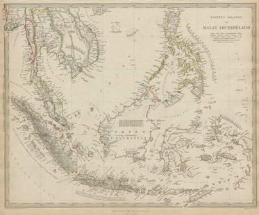
TITLE/CONTENT OF MAP: 'Malay Archipelago or East India Islands'
Vignettes: Victoria Mount - New Guinea; Near Sarawak - Borneo; Natives of New Guinea; The Bee Bear. The map covers the area from Burma and South China to the Torres Strait/Gulf of Carpentaria/North Australia; Includes the modern states of the Philippines, Indonesia; Indochina, Sunda Islands, New Guinea, Borneo, Sumatra, Java. Marked on the map are Siam, Cochin China & Martaban Tenasserim, Hong Kong & Singapore
The top image on the right hand side shows the entire map. To view a close up of the map showing the level of printed detail, please click on the bottom image on the right hand side.
DATE PRINTED: 1851
IMAGE SIZE: Approx 36.5 x 26.5cm, 14.5 x 10.25 inches (Large)
TYPE: Antique engraved map by J Rapkin, published by John Tallis. Original outline hand colour, decorative border, and attractive inset vignette views
CONDITION: Good; suitable for framing. However, please note: Tight bottom margin below caption; The image shown may have been taken from a different example of this map than that which is offered for sale. The map you will receive is in good condition but there may be minor variations in the condition from that shown in the image. This map was coloured by hand at the time of publication, thus the colouration may vary slightly between different examples of the map; the colouring applied to the map you receive may differ slightly from that shown in the image. Decorative title slightly trimmed at top. Please check the scan for any blemishes prior to making your purchase. Please contact us if you would like to arrange to view this map. Virtually all antiquarian maps and prints are subject to some normal aging due to use and time which is not obtrusive unless otherwise stated. We offer a no questions asked return policy.
AUTHENTICITY: This is an authentic historic map, published at the date stated above. It is not a modern copy.
VERSO: There is nothing printed on the reverse side, which is plain
ARTIST/CARTOGRAPHER/ENGRAVER: Map drawn and engraved by J. Rapkin; vignette illustrations drawn by H Warren & engraved by T Smith. Published by John Tallis & Co
PROVENANCE: "Tallis's Illustrated Atlas and Modern History of the World, Geographical, Political, Commercial and Statistical", edited by R Montgomery Martin Esq., published by John Tallis and Company, London & New York [Tallis's Illustrated Atlas]
Reserve: $225.00
Shipping:Domestic: Flat-rate of $23.00 to anywhere within the contiguous U.S. International: Foreign shipping rates are determined by destination. Combined shipping: Please ask about combined shipping for multiple lots before bidding. Location: This item ships from United Kingdom.
Your purchase is protected:
Photos, descriptions, and estimates were prepared with the utmost care by a fully certified expert and appraiser. All items in this sale are guaranteed authentic.
In the rare event that the item did not conform to the lot description in the sale, Jasper52 specialists are here to help. Buyers may return the item for a full refund provided you notify Jasper52 within 5 days of receiving the item.
Vignettes: Victoria Mount - New Guinea; Near Sarawak - Borneo; Natives of New Guinea; The Bee Bear. The map covers the area from Burma and South China to the Torres Strait/Gulf of Carpentaria/North Australia; Includes the modern states of the Philippines, Indonesia; Indochina, Sunda Islands, New Guinea, Borneo, Sumatra, Java. Marked on the map are Siam, Cochin China & Martaban Tenasserim, Hong Kong & Singapore
The top image on the right hand side shows the entire map. To view a close up of the map showing the level of printed detail, please click on the bottom image on the right hand side.
DATE PRINTED: 1851
IMAGE SIZE: Approx 36.5 x 26.5cm, 14.5 x 10.25 inches (Large)
TYPE: Antique engraved map by J Rapkin, published by John Tallis. Original outline hand colour, decorative border, and attractive inset vignette views
CONDITION: Good; suitable for framing. However, please note: Tight bottom margin below caption; The image shown may have been taken from a different example of this map than that which is offered for sale. The map you will receive is in good condition but there may be minor variations in the condition from that shown in the image. This map was coloured by hand at the time of publication, thus the colouration may vary slightly between different examples of the map; the colouring applied to the map you receive may differ slightly from that shown in the image. Decorative title slightly trimmed at top. Please check the scan for any blemishes prior to making your purchase. Please contact us if you would like to arrange to view this map. Virtually all antiquarian maps and prints are subject to some normal aging due to use and time which is not obtrusive unless otherwise stated. We offer a no questions asked return policy.
AUTHENTICITY: This is an authentic historic map, published at the date stated above. It is not a modern copy.
VERSO: There is nothing printed on the reverse side, which is plain
ARTIST/CARTOGRAPHER/ENGRAVER: Map drawn and engraved by J. Rapkin; vignette illustrations drawn by H Warren & engraved by T Smith. Published by John Tallis & Co
PROVENANCE: "Tallis's Illustrated Atlas and Modern History of the World, Geographical, Political, Commercial and Statistical", edited by R Montgomery Martin Esq., published by John Tallis and Company, London & New York [Tallis's Illustrated Atlas]
Reserve: $225.00
Shipping:
Your purchase is protected:
Photos, descriptions, and estimates were prepared with the utmost care by a fully certified expert and appraiser. All items in this sale are guaranteed authentic.
In the rare event that the item did not conform to the lot description in the sale, Jasper52 specialists are here to help. Buyers may return the item for a full refund provided you notify Jasper52 within 5 days of receiving the item.
Buyer's Premium
- 15%
MALAY ARCHIPELAGO/EAST INDIA ISLANDS Philippines
Estimate $250 - $300
4 bidders are watching this item.
Shipping & Pickup Options
Item located in United Kingdom$23 shipping in the US
Payment
See More Items From This Jasper52 Seller

Auction Curated By

Maps Expert
Related Searches
TOP