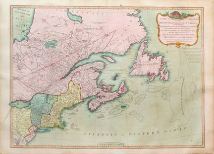
Bellin Map of North America
Abraham Jacob Bogdanove Sale History
View Price Results for Abraham Jacob BogdanoveRelated Maps & Atlases
More Items in French Maps & Atlases
View MoreRecommended Transportation & Travel Collectibles
View More


Item Details
Description
BELLIN, Jacques Nicholas (1703-1772).
Carte de l'Amerique Septentrionale Depuis le 28 Degre de Latitude Jusqu'au 72.
Engraved map with original hand color.
Paris, 1755.
25 1/2" x 36 1/2" sheet, 26 1/2" x 36 1/2" framed.
First edition of this large chart that covers nearly all of North America. The West is mostly blank, coastlines are only partially delineated, the Sea of the West (La Mer de l'Ouest) is named but not delineated. There is also a River of the West flowing westward from Lake Winnipeg but ceasing near the Montagne de Pierre brillante suivant le report des Sauvages (mountain of brilliant stones as reported by the savages). The names of explorers responsible for discoveries are noted along the coasts. There is good detail of rivers, lakes, Indian nations, and forts in the interior.
Buyer's Premium
- 25%
Bellin Map of North America
Estimate $4,000 - $7,000
2 bidders are watching this item.
Shipping & Pickup Options
Item located in New York, NY, usOffers In-House Shipping
Local Pickup Available
Payment

Related Searches
TOP


![Manuscript Map of Givet, France on the Belgian Border: [Givet, France]. "Charlemont les deux Givets et la Couronne d'Haurs Pour servir au Projet de mil Sept cent trente sept" Fine manuscript plan in ink and colours on paper (no visible watermark), scale a](https://p1.liveauctioneers.com/1968/273926/143704769_1_x.jpg?height=310&quality=70&version=1672435208)


![A block puzzle with maps of Europe, England, Ireland, Scotland, America and the World: [BLOCK PUZZLE] Boxed set of 20 cubical blocks, each face with a portion of one of six hand-colored lithographed maps. Probably Irish: mid-nineteenth century. Blocks overall 7 5/8 x 6 1/4 inches (19.5](https://p1.liveauctioneers.com/292/330597/178279620_1_x.jpg?height=310&quality=70&version=1716409282)


![[FLAGS]. 31-star American parade flag. Ca 1850-1859.: [FLAGS]. 31-star American parade flag. Ca 1850-1859. 22 x 36 1/2 in. cotton flag with 31 printed stars, configured in a double medallion surrounding a much larger central star, that is haloed in both](https://p1.liveauctioneers.com/197/329785/177758218_1_x.jpg?height=310&quality=70&version=1715625218)


