


Scarce German map of independent Texas 1843
Similar Sale History


![Tallis map of U.S. with independent Texas: Heading: (Texas)Author: Tallis, JohnTitle: United States Place Published: London Publisher: Date Published: [1850] Description: Engraved map, hand-colored in outline; with 7 uncolored engraved](https://p1.liveauctioneers.com/642/174090/87617797_1_x.jpg?height=310&quality=70&version=1595023143)
Recommended Items


![1898 Rand McNally Map of Texas [verso] Indian Territory and Oklahoma -- Texas [verso] Oklahoma and: Title: 1898 Rand McNally Map of Texas [verso] Indian Territory and Oklahoma -- Texas [verso] Oklahoma and Indian Territory Cartographer: Rand McNally Year / Place: 1898, Chicago Map Dimension (in.): 9](https://p1.liveauctioneers.com/5584/329422/177662173_1_x.jpg?height=310&quality=70&version=1715717898)


Item Details
Description
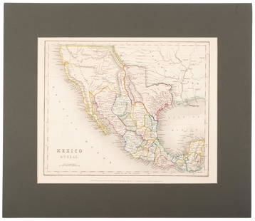
Heading: (Texas)
Author: Flemming, Carl
Title: Texas
Place Published: Glogau
Publisher:
Date Published: 1843
Description:
Author: Flemming, Carl
Title: Texas
Place Published: Glogau
Publisher:
Date Published: 1843
Description:
Lithographed map, hand-colored in outline. 39.5x32 cm. (16x13").
A reduced version of Arrowsmith's map of 1841, with inset of "Plan der Galveston Bay." An important Texas map, which shows the locations of Indian tribes, roads, rivers, and mountains. The numbered key at the upper right lists 30 counties. Railroad development is evident. Cities, towns, forts, springs and many more items are identified. In the Indian Territory, public lands are limited to the western panhandle and many Indian ceded lands are identified by date.
Condition
Light foxing in margins and left side of image; very good.
***AMENDED*** Half the map has dampstaining, most noticeable on the verso.
Buyer's Premium
- 25%
Scarce German map of independent Texas 1843
Estimate $700 - $1,000
6 bidders are watching this item.
Shipping & Pickup Options
Item located in Berkeley, CA, usOffers In-House Shipping
Local Pickup Available
Payment

Related Searches
TOP