


1834 Map of the route passed over by an expedition into
Similar Sale History
View More Items in Tribal & Native American Artifacts


Related Tribal & Native American Artifacts
![Ute Chief Ourey Autograph Cut c1880 [182358]: Ute Indian Chief Ourey autograph cut 2"x 3.5" dated February 19, 1880 (The year he passed). Chief Ourey was born in Colorado to an Ute father and Apache mother. His father was the tribal leader until](https://p1.liveauctioneers.com/2699/331494/178785239_1_x.jpg?height=310&quality=70&version=1717094654)


![Washoe Basket Maker Edward Curtis Folio Photo [179308]: This is a 21"x 26" framed photo by Edward Sheriff Curtis (1868-1956) titled "Washo Basket Maker". In 1906, banker, business leader, and financier John Pierpont Morgan, funded an ambitious project with](https://p1.liveauctioneers.com/2699/331494/178785269_1_x.jpg?height=310&quality=70&version=1717094654)
More Items in Tribal & Native American Artifacts
View More


Recommended Art
View More
![Emilio Grau-Sala "Sur la Plage" Oil on Canvas: Emilio Grau-Sala (Spanish, 1911-1975), "Sur la Plage" [On The Beach], Oil on Canvas, 1958, signed "Grau Sala" lower right, signed, inscribed "Trouville", dated, and titled to verso. Image: 21.5" H x 2](https://p1.liveauctioneers.com/5649/328023/176731071_1_x.jpg?height=310&quality=70&version=1714409606)


Item Details
Description
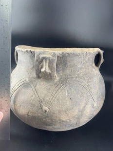
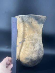
This highly detailed map depicts the territory of the region between the Red River and Lake Superior within present day Minnesota. The map is centered on the course of the Missisippi River above Lake Pipin, the Sioux Villages and the Falls of St. Anthony.
The map was a remarkable accomplishment, as Allen had only a compass which he placed before him in the canoe. With each change in direction of the river he made notes in his field book and by establishing a scale of proportions in the lengths of the reaches, "I was also in this way enabled to lay down and preserve the general curve of a river with surprising accuracy. On the portion of the river above Cass Lake which was the least known of any part of the river and route, I bestowed on tracing and computing of distance the most unremitted attention."
The region of present day Minnesota from the western tip of Lake Superior to the Red River is depicted, including Fort Snelling, countless Indian villages, tribal territories and trading posts. Allen reported having spoken with fur traders at every opportunity, obtaining information as to the state and nature of their trade, their relations with the British companies and the amount of business they did.
The map appeared in Henry Schoolcraft and James Allen's Journal of an Expedition into the Indian Country to the Source of the Mississippi, in 1832.
Condition
This map is in C+ condition. Separations have been repaired with archival material on the verso.
Dimensions
15.25 x 18.75 in
Buyer's Premium
- 12.5%
1834 Map of the route passed over by an expedition into
Estimate $150 - $275
3 bidders are watching this item.
Shipping & Pickup Options
Item located in Chicago, IL, usSee Policy for Shipping
Payment

Related Searches
TOP