


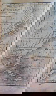
Merian map of America
Similar Sale History
View More Items in Maps & Atlases


![1653 Merian Map of Northern Germany -- Meklenburg: Title: 1653 Merian Map of Northern Germany -- Meklenburg Ducatus Cartographer: Merian [family] Year / Place: 1653, Frankfurt Map Dimension (in.): 10.8 X 14.1 in. This is a very handsome map of the his](https://p1.liveauctioneers.com/5584/195879/98794817_1_x.jpg?height=310&quality=70&version=1614724478)
![[ANTIQUE MAPS] AMERICA SEPTENTRIONALIS: [ANTIQUE MAPS] AMERICA SEPTENTRIONALIS. unknown. On thick paper. 44x30cm. Hand-coloured. Frame not included. Map will be removed from frame and securely shipped in cardboard tube. Not examine under th](https://p1.liveauctioneers.com/8321/253807/131946545_1_x.jpg?height=310&quality=70&version=1657215800)


Related Maps & Atlases


![South & Central America Map Lot c1800's [180163]: Collection of (6) maps of South and Central America. (2) Published by S. August Mitchell Jr., Venezuela, Guiana, Peru; Ecuador, "Chili", Brazil, Bolivia, Paraguay, Uruguay, with intricate floral borde](https://p1.liveauctioneers.com/2699/331495/178785795_1_x.jpg?height=310&quality=70&version=1717094933)
![French Map of America Southwest & Mexico [179298]: French map the American Southwest and Mexico. This is a double truck from an 18th century book and measures 10x 14". Map from 1787 during the reign of Louie XVI the king France who beheaded in1793.Riv](https://p1.liveauctioneers.com/2699/331495/178785763_1_x.jpg?height=310&quality=70&version=1717094933)
![North America Map circa 1800s [179302]: Early map of the North American continent circa 1810. Shows the western area as New Albion, southwest Canada as New Caledonia and the Russian Possessions of western Canada and Alaska. Also noted are s](https://p1.liveauctioneers.com/2699/331495/178785793_1_x.jpg?height=310&quality=70&version=1717094933)
![French Map of America Southeast [179304]: Northeastern American map published 1788 from a French cartographer. Map measures 9"x 13". Published during America's War of Independence from Great Britain (1176-1783), this map features the mid-Atla](https://p1.liveauctioneers.com/2699/331495/178785746_1_x.jpg?height=310&quality=70&version=1717094933)
![[MAP]. TODESCHI, Pietro. [Nova et Acurata Totius Americae Tabula auct. G.I. Blaeu] America quarta: [MAP]. TODESCHI, Pietro. [Nova et Acurata Totius Americae Tabula auct. G.I. Blaeu] America quarta pars orbis quam plerunq, nuvum orbem appellitant primo detecta est anno 1492 a Christophoro Columbo...](https://p1.liveauctioneers.com/197/329395/177650542_1_x.jpg?height=310&quality=70&version=1715364962)


![Jacob Monk 1853 Map of North America [173506]: Large wall map, typical nvarnish finish, mounted to board for viewing. "New map of that portion of North America exhibiting the United States and Territories, the Canadas, New Brunswick, Nova Scotia,](https://p1.liveauctioneers.com/2699/331495/178785775_1_x.jpg?height=310&quality=70&version=1717094933)
More Items in Maps & Atlases
View More![[MAPS]. HOMANN, Johann Baptist, HOMANN HEIRS, and Georg Matthäus SEUTTER. [Composite Atlas].: [MAPS]. HOMANN, Johann Baptist (1663-1724), HOMANN HEIRS, and Georg Matthäus SEUTTER (1678-1757). [Composite Atlas]. [Nuremberg, Augsburg, and others: Homann Heirs and others, maps dated between](https://p1.liveauctioneers.com/197/329395/177650530_1_x.jpg?height=310&quality=70&version=1715364962)


![[MAP]. ORTELIUS, Abraham. Americae Sive Novi Orbis, Nova Descriptio. 1573.: [MAP]. ORTELIUS, Abraham (1527-1598). Americae Sive Novi Orbis, Nova Descriptio. Antwerp, 1573. Engraved map with hand-coloring. Framed and double glazed, visible area 375 x 521 mm (unexamined out of](https://p1.liveauctioneers.com/197/329395/177650534_1_x.jpg?height=310&quality=70&version=1715364962)

![[MAP]. SPEED, John. A New Mappe of the Romane Empire. 1676.: [MAP]. SPEED, John (ca 1551-1629). A New Mappe of the Romane Empire. London: Basset & Chiswell, 1676. Engraved map with hand-coloring. Framed and double glazed, sight 419 x 559 mm. Decorative cartouch](https://p1.liveauctioneers.com/197/329395/177650541_1_x.jpg?height=310&quality=70&version=1715364962)
![Set of Twelve Satirical Anthropomorphic Maps of Europe: [SATIRICAL MAPS] A set of twelve satirical anthropomorphic maps of Europe. London: circa 1868. A set of 12 (believed complete) lithographed maps by Vincent Brooks, Day & Son, London, each offering](https://p1.liveauctioneers.com/292/330597/178279264_1_x.jpg?height=310&quality=70&version=1716409282)


![[MAP]. ORTELIUS, Abraham. Turcici Imperii Descriptio.1592.: [MAP]. ORTELIUS, Abraham (1527-1598). Turcici Imperii Descriptio. Antwerp, 1592. Engraved map with hand-coloring. Matted, framed, and double glazed, sight 406 x 521 mm (unexamined out of frame). Decor](https://p1.liveauctioneers.com/197/329395/177650538_1_x.jpg?height=310&quality=70&version=1715364962)
![[MAP]. ORTELIUS, Abraham. Romani Imperii Imago. 1592.: [MAP]. ORTELIUS, Abraham (1527-1598). Romani Imperii Imago. Antwerp, 1592. Engraved map with hand-coloring. Matted, framed, and double glazed, visible area 381 x 521 mm (unexamined out of frame). 6 de](https://p1.liveauctioneers.com/197/329395/177650537_1_x.jpg?height=310&quality=70&version=1715364962)

![[MAP]. ORTELIUS, Abraham. Aevi Veteris, Typus Geographicus. 1601.: [MAP]. ORTELIUS, Abraham (1527-1598). Aevi Veteris, Typus Geographicus. Antwerp, 1601. Engraved map with hand-coloring. Matted, framed, and double glazed, visible area 343 x 470 mm (unexamined out of](https://p1.liveauctioneers.com/197/329395/177650532_1_x.jpg?height=310&quality=70&version=1715364962)
Recommended Transportation & Travel Collectibles
View More


Item Details
Description
Author: Merian, Matthaus
Title: America Noviter Delineata
Place Published: Frankfurt
Publisher:
Date Published: 1638
Description:
Copper-engraved map. 27.6x35.7 cm. (10¾x14").
Map of the Americas, a reduced version of Hondius' map of 1631, with inset of Greenland. There are two sea monsters and two detailed sailing ships in the oceans, and the geographical peculiarities include a large western U.S. lake draining into the Gulf of California ("Mar Vermeo"), a large lake in Guiana, etc. California is in its pre-island configuration. Unlike many Merian maps, this is actually signed "M. Merian fecit" in the plate at lower right. The map was first issued in the 1638 edition of Neuwe Archontoligica Cosmica (the German translation of Pierre D'Avity's Les Empires du Monde), and was also issued in the later editions of 1646 and 1695. Burden 251, plate 251; Wagner, Northwest Coast, 329.
Condition
Buyer's Premium
- 25%
Merian map of America
Shipping & Pickup Options
Item located in San Francisco, CA, usPayment
