


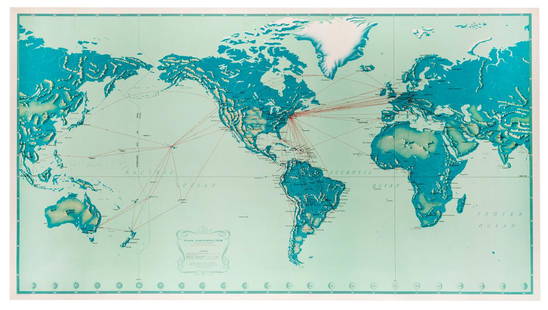
Large map of world showing transport routes 1876
Similar Sale History


![Travels In N. America In1827-28, hand colored map, 1830: Title: Travels In North America, In The Years 1827 And 1828 Provenance: IN THREE VOLUMES, 1830, with large hand colored folding map of United States and Canada showing Capt. Hall's route. [HOWES H 47]](https://p1.liveauctioneers.com/5584/144949/73283335_1_x.jpg?height=310&quality=70&version=1561753751)


Recommended Items


Item Details
Description
Heading: (World)
Author: Marié-Davy, Hippolyte
Title: Planisphère Chatelain, ou carte des voies de communication établies dans le monde entier au moyen de la vapeur et de l'électricité "World's Steam and Electric Map"
Place Published: Paris
Publisher:Lanée
Date Published: 1876
Description:
Author: Marié-Davy, Hippolyte
Title: Planisphère Chatelain, ou carte des voies de communication établies dans le monde entier au moyen de la vapeur et de l'électricité "World's Steam and Electric Map"
Place Published: Paris
Publisher:Lanée
Date Published: 1876
Description:
Lithographed map with hand coloring. 121x168 cm (47¾x66¼"), backed with linen & sectioned for folding.
Map of the world, includes insets of the United States and Europe, as well as countries' flags sprinkled throughout the map marking territories. The legend also marks pathways of communication established by steam and those by electricity. OCLC/WorldCat lists two copies of this1876 edition, at the University of Michigan and the National Library of Poland, as well as a handful of other editions from the 1870's and 1880's.
Condition
Some modest soiling, mild discoloration adjecent to the folds, very good.
Buyer's Premium
- 25%
Large map of world showing transport routes 1876
Estimate $500 - $800
2 bidders are watching this item.
Shipping & Pickup Options
Item located in San Francisco, CA, usSee Policy for Shipping
Payment

Related Searches
TOP