Sold20191955 Lockheed World Map adTitle/Content of Map: 1955 Lockheed World Map ad Date: 1955Cartographer: Lockheed Size: 13.6 X 21 in. when joined This is a fascinating world map showing the routes flown on Lckheed's Super ConstillatSee Sold Price
Sold2018Air France. Large World Map Airways Route Poster.Masse, Jean. Air France. Large World Map Airways Route Poster. Paris: R. Graindorge/Perceval, ca. 1961. Color map of the world detailing the airline's routes. Linen backed. 45 ½ x 81". Small browSee Sold Price
Sold2022World.- Mortier (Pierre) Carte Generale de Toutes les Costes du Monde et les Pays NouvellementWorld.- Mortier (Pierre) Carte Generale de Toutes les Costes du Monde et les Pays Nouvellement Decouvert, large two sheet map of the world, showing California as an island and recent coastal discoveriSee Sold Price
Sold2017Johnson: Map of the World On Mercator's ProjectionMap Title: Map of the World On Mercator's Projection Publisher: Johnson And Ward, Alvin Jewett Johnson Publishing Date: 1861 Size: Double Folio - 15.25 x 24.00 inches Large, Handsome world map showingSee Sold Price
Sold2020SOUTHERN STATES TRADE ROUTE MAPLarge Framed Trade Route Map showing waterways and towns from the Mississippi River to Charles Town. Geographic Area Covered: Southern States, South Carolina,Santee River Valley, Savannah River ValleySee Sold Price
Sold2024East Asia, East Indies & Australasia sea & shipping routes 1917 old mapCAPTION PRINTED BELOW PICTURE: 'Map showing the Sea Routes' DATE PRINTED: 1917 IMAGE SIZE: Approx 29.0 x 26.0cm, 11.5 x 10.25 inches (Large); Please note that this is a folding map. TYPE: Antique coloSee Sold Price
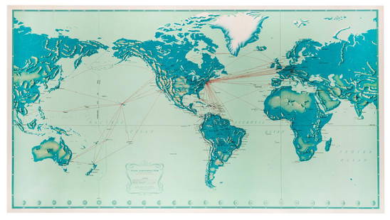
Sold2018Two Large Maps of the WorldTwo Large Maps of the World, American Air Lines & Menier Chocolate. American Airlines Air World Map, showing the distances to various cities and locations from the geographical center of the United StSee Sold Price
Sold2023Perry, Matthew 1856 Large Map. Chart of the World. Track of the U.S Steam Ships"Chart of the World showing the Track of the U. S. Steam Frigates Mississippi, Susquehanna, and Powhatan" Large Folio Lithograph Map Published 1856, Washington for "Narrative of the Expedition of an ASee Sold Price
Sold2019Large Colored Map of Louisiana, 1907, from the RandLarge Colored Map of Louisiana, 1907, from the Rand McNally Indexed Atlas of the World, double folio, showing railroads, presented in a mahogany frame with a gilt liner, H.- 19 1/4 in., W.- 25 3/4 in.See Sold Price
Sold2019Pan American Airways System. World Map 1956.Pan American Airways System. World Map 1956. Art by John Brown, cartography by John Philip. Offset poster showing the airline’s routes across the world. 34 x 60”. Inpainting to lower image, minorSee Sold Price
Sold2018Pan American Airways System. World Map 1968Pan American Airways System. World Map 1968. Art by John Brown, cartography by John Philip. Offset poster showing the airline's routes across the world. Linen backed. 18 x 32". A.See Sold Price
Sold2019Travels In N. America In1827-28, hand colored map, 1830Title: Travels In North America, In The Years 1827 And 1828 Provenance: IN THREE VOLUMES, 1830, with large hand colored folding map of United States and Canada showing Capt. Hall's route. [HOWES H 47]See Sold Price
Sold2016Rare Vintage Map of Afghanistan War Rug: 5'9'' x 7'3''Rare Vintage Afghanistan War Rug showing map of world with Afghanistan at its center from refugee camp in Peshawar, Pakistan. 1997. Size: 5'9'' x 7'3'' (175 x 221 cm). An outstanding and large exampleSee Sold Price
Sold2018Cram: Antique Map of the West Indies, 1892West Indies. Cram's large, highly detailed map of the West Indies from his Superior Atlas of the World features shipping routes and undersea cables. On the verso are two separate maps: "Jamaica, HaitiSee Sold Price
Sold2022Rare 1836 Col. Dodge Expedition map - 1st printing, SteenLarge and important early copper engraved map of the western U. S. showing the route of Col. Henry Dodge’s 1835 Expedition from Fort Leavenworth to the Rocky Mountains. Rare first printing withSee Sold Price
Sold20231902 Map of Vermont Highways, Natural Features, Railroad Stations, etc...This is a large, wall hanging 1902 Complete Map of Vermont Showing Highways and Natural Features, with an Index of All Cities, Villages, Post Offices, and Railroad Stations. Railroad routes are also sSee Sold Price
Sold2022Transport Map of Central Europe. Railways mail routes. LARGE 1959 oldTITLE/CONTENT OF MAP: 'Transport Map of Central Europe' DATE PRINTED: 1959 IMAGE SIZE: Approx 49.5 x 72.0cm, 19.5 x 28.25 inches (Large); Please note that this is a folding map. TYPE: Antique colour mSee Sold Price
Sold2024MEDITERRANEAN & BLACK SEAS showing steamship routes & railways 1911 old mapTITLE OF THE MAP: 'The Mediterranean; Inset Canary Islands' DATE PRINTED: 1911 IMAGE SIZE: Approx 27.0 x 51.0cm, 10.75 x 20 inches (Large); Please note that this is a folding map. TYPE: Antique colourSee Sold Price
Sold2019Bartholomew, John 1922 Pair Large Maps of East Indies"Farther India" showing Siam, Indonesia, Singapore, Malaysia. Together with "Malay Archipelago" Large Lithograph Map Published 1922 by The Times, London for "The Times Survey Atlas of the World" MapsSee Sold Price
Sold2020Bartholomew, John 1922 Pair Maps. New Zealand & Pacific"New Zealand" and "Islands of Oceania" The latter showing Hawaii and other Pacific Islands. Large Lithograph Maps Published 1922 by The Times, London for "The Times Survey Atlas of the World" Maps bySee Sold Price
Sold2019Gross, Alexander 1920 Pair of LG Maps. Cuba & Jamaica"Cuba and Jamaica" and "West Indies" also showing Cuba and Jamaica. Large Lithograph Maps Published 1920, London for "The Daily Telegraph Victory Atlas of the World" by Alexander Gross. Centre fold asSee Sold Price
Sold2019Bartholomew, John 1922 Group of 3 Maps of AsiaSouth Western Asia, Asia - Political, and Father India showing Siam and Indo China. Large Lithograph Maps Published 1922 by The Times, London for "The Times Survey Atlas of the World" Maps by John GeoSee Sold Price
Sold20211876 RR map - NE U.S. in uncommon formatLarge and uncommon map of the upper eastern seaboard of the United States in an unusual layout. From the very scarce 1876 Jones and Hamilton Historical Atlas of the World Illustrated. Clean and soundSee Sold Price
Sold2019Rare 1st ed. 1847 ethno map of Europe/AsiaA large full color map of Europe and Asia showing the ethnographic distribution of people. Includes an accompanying chart. From the first comprehensive physical atlas of the world. This map comes fromSee Sold Price
2 days LeftThe Bidder AuctionsThe map of the railways in the Land of Israel - published by the Surveying Department of the British$30
Jun 20The Ross Art GroupOriginal Vintage Air France World Route Map Vickers Viscount Poster 1956 Constellation$600
Featured15 hrs LeftJasper521653 Blaeau Map of the Dnieper River -- Lectori S. Hunc Borysthenis Tractum ut ad Nostrum$850
14 hrs LeftJasper521771 ASTRONOMY by Joseph M. de La Lande 2 VOLUMES ILLUSTRATED antique in FRENCH$480
1 day LeftCedarburg Auction & Appraisals LLCSet of Four Maps Showing All of Spain and Portugal c. 1700's$450(2 bids)
Featured15 hrs LeftJasper52c1720 World showing Dutch East India Co possessions. CA as a island. By J.Malherbe$600
Jun 08Connoisseur AuctionsEarly 1900's Railway Service Map, Illinois, Ohio, Indiana, Kentucky, Tennessee$20(1 bid)


![Travels In N. America In1827-28, hand colored map, 1830: Title: Travels In North America, In The Years 1827 And 1828 Provenance: IN THREE VOLUMES, 1830, with large hand colored folding map of United States and Canada showing Capt. Hall's route. [HOWES H 47]](https://p1.liveauctioneers.com/5584/144949/73283335_1_x.jpg?height=310&quality=70&version=1561753751)


