


Large/scarce 1861 map of New York Bay
Similar Sale History
View More Items in Maps & Atlases


Related Maps & Atlases


More Items in Maps & Atlases
View More![[Maps] Gio. Ant. Magnini, Italia, 1620: [Maps] Gio. Ant. Magnini, Italia, 1620, Giovanni Antonio Magnini. Italia, data in luce da Fabio suo figliuolo al Serenissimo Ferdinado Gonzaga Duca di Matoua edi Monserrato etc. Bologna, for Sebastian](https://p1.liveauctioneers.com/188/326797/176317457_1_x.jpg?height=310&quality=70&version=1713847031)
![[Maps] Martin Zeiler, Itinerarium Italiae, 1640: [Maps] Martin Zeiler, Itinerarium Italiae, 1640, Martini Zeilleri. Itinerarium Italiae Nov-Antiquae: oder, Raiss-Beschreibung durch Italien, Matthaus Merian, Frankfurt, 40 plates, most double-page, in](https://p1.liveauctioneers.com/188/326797/176317459_1_x.jpg?height=310&quality=70&version=1713847031)


![[MAP]. TODESCHI, Pietro. [Nova et Acurata Totius Americae Tabula auct. G.I. Blaeu] America quarta: [MAP]. TODESCHI, Pietro. [Nova et Acurata Totius Americae Tabula auct. G.I. Blaeu] America quarta pars orbis quam plerunq, nuvum orbem appellitant primo detecta est anno 1492 a Christophoro Columbo...](https://p1.liveauctioneers.com/197/329395/177650542_1_x.jpg?height=310&quality=70&version=1715364962)


Recommended Transportation & Travel Collectibles
View More


Item Details
Description
Reserve Reduced!
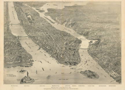
Large and scarce 1861 coastal map of New York City and its harbor. One of the earliest 19th century charts to depict New York City as we know it today. It shows Manhattan, Brooklyn and Staten Island, plus the Queens and Bronx areas that would be formed from the regions around Mott Haven and Astoria toward the end of the century. Also includes Jersey City, Newark and Hoboken. Inland details are quite thorough especially in regard to developing towns and communities. You can actually see individual houses! Contains a wealth of practical information including oceanic depths, harbors and navigation tips on important channels. Also includes tables of light houses and beacons, tides and magnetic declination as well as detailed sailing instructions. Modern hand-color. Triangulation prepared by J. Ferguson and E. Blunt. Topography by H. L. Whiting, S. A. Gilbert, A. M Harrison, F. W. Door, C. Rockwell and J. M E. Chan. Hydrography by R. Wainwright and T. A. Craven. Production supervised by A. D. Bache, Superintendent of the Survey of the Coast of the United States and one of the most influential American cartographers of the 19th century. Published 1861 by the U. S. Coast Survey. Very light toning, which is unusual for these particular maps. Most folds reinforced with archival tape. Frame is 27 x 30.5.
Please note that this lot has a confidential reserve. When you leave a bid in advance of the auction, submit your maximum. The bidder who has submitted the highest bid wins the lot, provided the bid exceeds the reserve price.
Shipping:Domestic: Flat-rate of $10.00 to anywhere within the contiguous U.S. International: Foreign shipping rates are determined by destination. Combined shipping: Please ask about combined shipping for multiple lots before bidding. Location: This item ships from Ohio.
Your purchase is protected:
Photos, descriptions, and estimates were prepared with the utmost care by a fully certified expert and appraiser. All items in this sale are guaranteed authentic.
In the rare event that the item did not conform to the lot description in the sale, Jasper52 specialists are here to help. Buyers may return the item for a full refund provided you notify Jasper52 within 5 days of receiving the item.
Large and scarce 1861 coastal map of New York City and its harbor. One of the earliest 19th century charts to depict New York City as we know it today. It shows Manhattan, Brooklyn and Staten Island, plus the Queens and Bronx areas that would be formed from the regions around Mott Haven and Astoria toward the end of the century. Also includes Jersey City, Newark and Hoboken. Inland details are quite thorough especially in regard to developing towns and communities. You can actually see individual houses! Contains a wealth of practical information including oceanic depths, harbors and navigation tips on important channels. Also includes tables of light houses and beacons, tides and magnetic declination as well as detailed sailing instructions. Modern hand-color. Triangulation prepared by J. Ferguson and E. Blunt. Topography by H. L. Whiting, S. A. Gilbert, A. M Harrison, F. W. Door, C. Rockwell and J. M E. Chan. Hydrography by R. Wainwright and T. A. Craven. Production supervised by A. D. Bache, Superintendent of the Survey of the Coast of the United States and one of the most influential American cartographers of the 19th century. Published 1861 by the U. S. Coast Survey. Very light toning, which is unusual for these particular maps. Most folds reinforced with archival tape. Frame is 27 x 30.5.
Please note that this lot has a confidential reserve. When you leave a bid in advance of the auction, submit your maximum. The bidder who has submitted the highest bid wins the lot, provided the bid exceeds the reserve price.
Shipping:
Your purchase is protected:
Photos, descriptions, and estimates were prepared with the utmost care by a fully certified expert and appraiser. All items in this sale are guaranteed authentic.
In the rare event that the item did not conform to the lot description in the sale, Jasper52 specialists are here to help. Buyers may return the item for a full refund provided you notify Jasper52 within 5 days of receiving the item.
Condition
Very good
Buyer's Premium
- 15%
Large/scarce 1861 map of New York Bay
Estimate $350 - $450
7 bidders are watching this item.
Shipping & Pickup Options
Item located in Ohio, US$10 shipping in the US
Payment
See More Items From This Jasper52 Seller

Auction Curated By

Maps Expert
Related Searches
TOP