
 Discovery- InteriorsBonhamsSponsored.Your ad here?


Discovery- Interiors
Bonhams
Sponsored.Your ad here?


 Discovery- InteriorsBonhamsSponsored.Your ad here?


Discovery- Interiors
Bonhams
Sponsored.Your ad here?

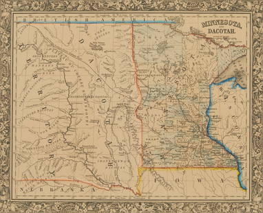
Early pocket map of Minnesota
Similar Sale History
View More Items in Maps & AtlasesRelated Maps & Atlases
More Items in Maps & Atlases
View MoreRecommended Transportation & Travel Collectibles
View More


Item Details
Description
Heading:
Author: Colton, J.H.
Title: Minnesota
Place Published: New York
Publisher:J.H. Colton & Co
Date Published: 1855
Description:
Author: Colton, J.H.
Title: Minnesota
Place Published: New York
Publisher:J.H. Colton & Co
Date Published: 1855
Description:
Folding color map, 12 x 15 inches. Folds into dark bluish blindstamped cloth boards, gilt cover title, advertisement on inside cover, 5x3½”.
One of the earliest pocket maps of Minnesota, extending its western border deep into what would become Dakota Territory, but here labeled "Northwest Territory." This is one of two Minnesota maps issued by Colton in 1855, in addition to a Chapman sectional map and a similar effort by Ensign & Thayer. Colton also produced Minnesota maps in 1853 and 1854. Quite rare. Not in Phillips' MAPS, nor Rumsey, nor Wheat Transmississippi West
Condition
Covers worn; bookseller label on inside front cover; map overall very good.
Buyer's Premium
- 25%
Early pocket map of Minnesota
Estimate $300 - $500
2 bidders are watching this item.
Shipping & Pickup Options
Item located in San Francisco, CA, usSee Policy for Shipping
Payment

Related Searches
TOP


![Early Map of Tennessee, Daniel Smith, 1795: A MAP OF THE TENNASSEE [sic] GOVERNMENT FORMERLY PART OF NORTH CAROLINA TAKEN CHIEFLY FROM SURVEYS BY GENL. D. SMITH & OTHERS, drawn by Daniel Smith, engraved by Joseph T. Scott, for "General Atlas Fo](https://p1.liveauctioneers.com/525/272425/142901899_1_x.jpg?height=310&quality=70&version=1671337478)


![[Maps] Martin Zeiler, Itinerarium Italiae, 1640: [Maps] Martin Zeiler, Itinerarium Italiae, 1640, Martini Zeilleri. Itinerarium Italiae Nov-Antiquae: oder, Raiss-Beschreibung durch Italien, Matthaus Merian, Frankfurt, 40 plates, most double-page, in](https://p1.liveauctioneers.com/188/326797/176317459_1_x.jpg?height=310&quality=70&version=1713847031)


![[Maps] Gio. Ant. Magnini, Italia, 1620: [Maps] Gio. Ant. Magnini, Italia, 1620, Giovanni Antonio Magnini. Italia, data in luce da Fabio suo figliuolo al Serenissimo Ferdinado Gonzaga Duca di Matoua edi Monserrato etc. Bologna, for Sebastian](https://p1.liveauctioneers.com/188/326797/176317457_1_x.jpg?height=310&quality=70&version=1713847031)


