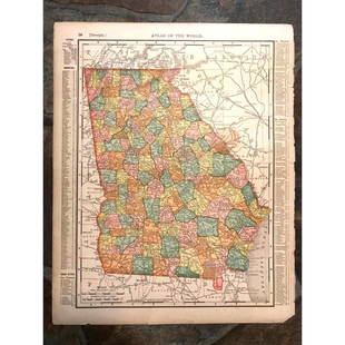
18th Century Map of Georgia and the Carolinas
Similar Sale History
View More Items in Maps & AtlasesRelated Maps & Atlases
More Items in Maps & Atlases
View MoreRecommended Transportation & Travel Collectibles
View More


Item Details
Description
1780s era map by French Cartographer Rigoberto Bonne (1727-1794). The hand colored map giving great details of the region. Bonne Served as Royal cartographer for France during the American Revolution and in the late 18th century, producing some of the most detailed and accurate maps of the period. Sight size: H9" W14 3/8"
Buyer's Premium
- 25%
18th Century Map of Georgia and the Carolinas
Estimate $250 - $400
7 bidders are watching this item.
Shipping & Pickup Options
Item located in Camden, SC, usSee Policy for Shipping
Payment

TOP


![Carte de la Caroline et Géorgie'. North/South Carolina: TITLE/CONTENT OF MAP: 'Carte de la Caroline et Géorgie [Map of the Carolinas and Georgia]' The top image on the right hand side shows the entire map. To view a close up of the map showing the level o](https://p1.liveauctioneers.com/5584/182355/91727171_1_x.jpg?height=310&quality=70&version=1603285541)


![1893 Civil War Map of Knoxville Area -- Topographical Map of the Approaches and Defences of: Title: 1893 Civil War Map of Knoxville Area -- Topographical Map of the Approaches and Defences of Knoxville, E. Tennessee… [with] Map No. 1 The Chickamauga Campaign... [Plate XLVIII] Cartograph](https://p1.liveauctioneers.com/5584/331064/178466410_1_x.jpg?height=310&quality=70&version=1716924723)


![[MAP]. ORTELIUS, Abraham. Turcici Imperii Descriptio.1592.: [MAP]. ORTELIUS, Abraham (1527-1598). Turcici Imperii Descriptio. Antwerp, 1592. Engraved map with hand-coloring. Matted, framed, and double glazed, sight 406 x 521 mm (unexamined out of frame). Decor](https://p1.liveauctioneers.com/197/329395/177650538_1_x.jpg?height=310&quality=70&version=1715364962)


![[MAP]. TODESCHI, Pietro. [Nova et Acurata Totius Americae Tabula auct. G.I. Blaeu] America quarta: [MAP]. TODESCHI, Pietro. [Nova et Acurata Totius Americae Tabula auct. G.I. Blaeu] America quarta pars orbis quam plerunq, nuvum orbem appellitant primo detecta est anno 1492 a Christophoro Columbo...](https://p1.liveauctioneers.com/197/329395/177650542_1_x.jpg?height=310&quality=70&version=1715364962)


![[MAPS]. HOMANN, Johann Baptist, HOMANN HEIRS, and Georg Matthäus SEUTTER. [Composite Atlas].: [MAPS]. HOMANN, Johann Baptist (1663-1724), HOMANN HEIRS, and Georg Matthäus SEUTTER (1678-1757). [Composite Atlas]. [Nuremberg, Augsburg, and others: Homann Heirs and others, maps dated between](https://p1.liveauctioneers.com/197/329395/177650530_1_x.jpg?height=310&quality=70&version=1715364962)


![[MAP]. ORTELIUS, Abraham. Americae Sive Novi Orbis, Nova Descriptio. 1573.: [MAP]. ORTELIUS, Abraham (1527-1598). Americae Sive Novi Orbis, Nova Descriptio. Antwerp, 1573. Engraved map with hand-coloring. Framed and double glazed, visible area 375 x 521 mm (unexamined out of](https://p1.liveauctioneers.com/197/329395/177650534_1_x.jpg?height=310&quality=70&version=1715364962)
![Set of Twelve Satirical Anthropomorphic Maps of Europe: [SATIRICAL MAPS] A set of twelve satirical anthropomorphic maps of Europe. London: circa 1868. A set of 12 (believed complete) lithographed maps by Vincent Brooks, Day & Son, London, each offering](https://p1.liveauctioneers.com/292/330597/178279264_1_x.jpg?height=310&quality=70&version=1716409282)


![[FLAGS]. 31-star American parade flag. Ca 1850-1859.: [FLAGS]. 31-star American parade flag. Ca 1850-1859. 22 x 36 1/2 in. cotton flag with 31 printed stars, configured in a double medallion surrounding a much larger central star, that is haloed in both](https://p1.liveauctioneers.com/197/329785/177758218_1_x.jpg?height=310&quality=70&version=1715625218)


![[CIVIL WAR]. 35-star American flag, possibly a Naval flag. Ca 1863-1865.: [CIVIL WAR]. 35-star American flag, possibly a Naval flag. Ca 1863-1865. Approx. 62 x 100 in. hand-sewn wool flag with 35 double-appliquéd cotton stars configured in 7/7/7/7/7 pattern (toning, soilin](https://p1.liveauctioneers.com/197/329785/177758220_1_x.jpg?height=310&quality=70&version=1715625218)