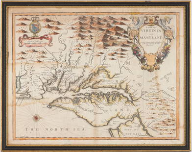
Exceptional 18th Century Map of The Carolinas, Maryland and Virginia
Similar Sale History
View More Items in Maps & AtlasesRelated Maps & Atlases
More Items in Maps & Atlases
View MoreRecommended Transportation & Travel Collectibles
View More


Item Details
Description
By Johann Baptist Homann, Germany, late 17th/early 18th century. Hand colored map of the region which is excellent and quite rare. The map giving excellent details of the region and having exquisite etching of native people and foliage at lower right with map seal. Well kept overall condition The work has not been laid down. H19 1/4" W23" (without mat and frame) The piece was purchased by the current owner's father at the Philadelphia Print Shop in the 1970s.
Buyer's Premium
- 25%
Exceptional 18th Century Map of The Carolinas, Maryland and Virginia
Estimate $2,000 - $4,000
16 bidders are watching this item.
Shipping & Pickup Options
Item located in Camden, SC, usShip with LiveAuctioneers
Local Pickup Available
Arrange Your Own Shipping
Payment
Accepts seamless payments through LiveAuctioneers

TOP


![Map of Maryland, Virginia Texas +: Map of South Carolina, Georgia, Florida, Alabama, Mississippi, Louisiana, Tennessee and Arkansas PLUS Maryland, Virginia, West Virginia & North Carolina [1 half sheet side] & Texas [1 half sheet side]](https://p1.liveauctioneers.com/5614/289638/153375966_1_x.jpg?height=310&quality=70&version=1684353133)


![HOMANN: Virginia Marylandia et Carolina, 1730-60: [Homann/Virginia/Maryland/Carolinas] VIRGINIA MARYLANDIA ET CAROLINA IN AMERICA SEPTENTRIONALI BRITANNORUM INDUSTRIA EXCULTAE. [Johann Baptiste Homann, ca. 1730-1760. First engraved c. 1714. This is a](https://p1.liveauctioneers.com/179/93063/47518611_1_x.jpg?height=310&quality=70&version=1473189014)


![1878 Mitchell Map of Virginia and West Virginia [verso] New Jersey, Maryland and Delaware -- County: Title: 1878 Mitchell Map of Virginia and West Virginia [verso] New Jersey, Maryland and Delaware -- County Map ofVirginia and West Virginia [Verso} County Map of Maryland and Delaware [with] County Ma](https://p1.liveauctioneers.com/5584/329422/177662152_1_x.jpg?height=310&quality=70&version=1715717898)
![1892 Cowles Civil War Map of Battles in Gettysburg, Virginia, W Virginia and Maryland -- Sketch of: Title: 1892 Cowles Civil War Map of Battles in Gettysburg, Virginia, W Virginia and Maryland -- Sketch of the battle of McDowell, VA. [and] Route Map of Gettysburg Campaign Lt-Gen T.J. Jackson [and] S](https://p1.liveauctioneers.com/5584/329422/177662185_1_x.jpg?height=310&quality=70&version=1715717898)


![1878 Mitchell Map of Washington, Oregon, Idaho, much of Montana [verso] Territory of Idaho: Title: 1878 Mitchell Map of Washington, Oregon, Idaho, much of Montana [verso] Territory of Idaho Cartographer: S Mitchell Year / Place: 1878, Philadelphia Map Dimension (in.): 10.8 X 13.4 in. This is](https://p1.liveauctioneers.com/5584/329422/177662232_1_x.jpg?height=310&quality=70&version=1715717898)
![[MAP]. ORTELIUS, Abraham. Turcici Imperii Descriptio.1592.: [MAP]. ORTELIUS, Abraham (1527-1598). Turcici Imperii Descriptio. Antwerp, 1592. Engraved map with hand-coloring. Matted, framed, and double glazed, sight 406 x 521 mm (unexamined out of frame). Decor](https://p1.liveauctioneers.com/197/329395/177650538_1_x.jpg?height=310&quality=70&version=1715364962)
![[MAP]. ORTELIUS, Abraham. Peregrinationis Divi Pauli Typus Corographicus. 1592.: [MAP]. ORTELIUS, Abraham (1527-1598). Peregrinationis Divi Pauli Typus Corographicus. Antwerp, 1592. Engraved map with hand-coloring. Matted, framed, and double glazed, visible area 381 x 533 mm (unex](https://p1.liveauctioneers.com/197/329395/177650535_1_x.jpg?height=310&quality=70&version=1715364962)
![[MAPS]. ORTELIUS, Abraham. A group of 3 engraved maps with hand-coloring.: [MAPS]. ORTELIUS, Abraham (1527-1598). A group of 3 engraved maps with hand-coloring, comprising: Gallia Vetus. Antwerp, 1592. Latin text on verso. Van den Broecke Ort194 (1592L5). -- Wirtenberg Ducat](https://p1.liveauctioneers.com/197/329395/177650539_1_x.jpg?height=310&quality=70&version=1715364962)


![[Maps] Gio. Ant. Magnini, Italia, 1620: [Maps] Gio. Ant. Magnini, Italia, 1620, Giovanni Antonio Magnini. Italia, data in luce da Fabio suo figliuolo al Serenissimo Ferdinado Gonzaga Duca di Matoua edi Monserrato etc. Bologna, for Sebastian](https://p1.liveauctioneers.com/188/326797/176317457_1_x.jpg?height=310&quality=70&version=1713847031)
![[Maps] Martin Zeiler, Itinerarium Italiae, 1640: [Maps] Martin Zeiler, Itinerarium Italiae, 1640, Martini Zeilleri. Itinerarium Italiae Nov-Antiquae: oder, Raiss-Beschreibung durch Italien, Matthaus Merian, Frankfurt, 40 plates, most double-page, in](https://p1.liveauctioneers.com/188/326797/176317459_1_x.jpg?height=310&quality=70&version=1713847031)


![[MAP]. TODESCHI, Pietro. [Nova et Acurata Totius Americae Tabula auct. G.I. Blaeu] America quarta: [MAP]. TODESCHI, Pietro. [Nova et Acurata Totius Americae Tabula auct. G.I. Blaeu] America quarta pars orbis quam plerunq, nuvum orbem appellitant primo detecta est anno 1492 a Christophoro Columbo...](https://p1.liveauctioneers.com/197/329395/177650542_1_x.jpg?height=310&quality=70&version=1715364962)


