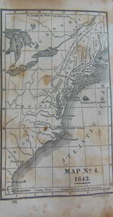
Cary: Antique Map of New England, 1811
Similar Sale History
View More Items in Maps & AtlasesRelated Maps & Atlases
More Items in American Maps & Atlases
View MoreRecommended Transportation & Travel Collectibles
View More


Item Details
Description
An original hand colored engraved 1811 map titled ""A New Map of Part of the United States of North America Containing New York, Vermont, New Hampshire, Massachusets, Connecticut, Rhode Island, Pennsylvania, New Jersey, Delaware, Maryland and Virginia. From The Latest Authorities"" created by John Cary created for his New Universal Atlas. The map includes the District of Main and Ohio, which was called The Western Territory at the time. The map contains many worthy features. At the mouth of the Cayanhoga River on Lake Erie, there is a note concerning a 70 ft rock which makes navigation dangerous. Another note indicates that the easiest passage from Lake Erie to the Missisisppi & Ohio Rivers is via the Sandusky & Sioto Rivers. A proposed fort is noted south of Detroit. The western boundary of the six Indian Nations in Western New York is noted. There are similar notes throughout the map, including annotations on each of the Great Lakes. The map inside the mat measures 21 x 18 1/2, the framed parameters are 27 1/2 x 26 1/4 x 1. "
Please note that this lot has a confidential reserve. When you leave a bid in advance of the auction, submit your maximum. Jasper52 will bid on your behalf as much as necessary to ensure that you meet the reserve price or that you remain in the lead, up to your maximum. The bidder who has submitted the highest bid wins the lot, provided the bid exceeds the reserve price.
Shipping:Domestic: Flat-rate of $60.00 to anywhere within the contiguous U.S. International: Foreign shipping rates are determined by destination. Location: This item ships from California
Authenticity:
Photos, descriptions, and estimates were prepared with the utmost care by a fully certified expert and appraiser. All items in this sale are guaranteed authentic. Please contact us if there is a misrepresentation so that the item can be returned.
Your purchase is protected:
In the rare event that your purchase from this auction does not meet your expectations, Jasper52 specialists are here to help. If the item did not conform to the lot description in the sale, U.S. buyers may return the item for a full refund provided you notify Jasper52 within 5 days of receiving the item.
Please note that this lot has a confidential reserve. When you leave a bid in advance of the auction, submit your maximum. Jasper52 will bid on your behalf as much as necessary to ensure that you meet the reserve price or that you remain in the lead, up to your maximum. The bidder who has submitted the highest bid wins the lot, provided the bid exceeds the reserve price.
Shipping:
Authenticity:
Photos, descriptions, and estimates were prepared with the utmost care by a fully certified expert and appraiser. All items in this sale are guaranteed authentic. Please contact us if there is a misrepresentation so that the item can be returned.
Your purchase is protected:
In the rare event that your purchase from this auction does not meet your expectations, Jasper52 specialists are here to help. If the item did not conform to the lot description in the sale, U.S. buyers may return the item for a full refund provided you notify Jasper52 within 5 days of receiving the item.
Condition
Some toning and foxing, wear to the frame. There is no glass. Has not been examined out of the frame.
Buyer's Premium
- 10%
Cary: Antique Map of New England, 1811
Estimate $400 - $450
7 bidders are watching this item.
Get approved to bid.
Shipping & Pickup Options
Item located in California, USSee Policy for Shipping
Payment
See More Items From This Jasper52 Seller

Auction Curated By

Maps Expert
TOP


![Mercator/Hondius: Antique Map of New Spain/Mexico, 1630: Title/Content of Map: 'Hispaniae Novae. Nova descriptio [New Spain, newly described]' A map of the western coast of "New Spain" (present-day Mexico)m Date Printed: c1630 Image Size: Approx 15.0 x 21.0](https://p1.liveauctioneers.com/5584/107656/55204900_1_x.jpg?height=310&quality=70&version=1502394810)


![[FLAGS]. 31-star American parade flag. Ca 1850-1859.: [FLAGS]. 31-star American parade flag. Ca 1850-1859. 22 x 36 1/2 in. cotton flag with 31 printed stars, configured in a double medallion surrounding a much larger central star, that is haloed in both](https://p1.liveauctioneers.com/197/329785/177758218_1_x.jpg?height=310&quality=70&version=1715625218)


