


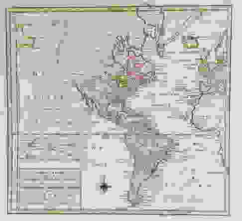
Tirion: Antique Map of the Western Hemisphere, 1754
Similar Sale History
View More Items in Maps & Atlases
![Mercator/Hondius: Antique Map of New Spain/Mexico, 1630: Title/Content of Map: 'Hispaniae Novae. Nova descriptio [New Spain, newly described]' A map of the western coast of "New Spain" (present-day Mexico)m Date Printed: c1630 Image Size: Approx 15.0 x 21.0](https://p1.liveauctioneers.com/5584/107656/55204900_1_x.jpg?height=310&quality=70&version=1502394810)


Related Maps & Atlases


More Items in North American Maps & Atlases
View More

Recommended Transportation & Travel Collectibles
View More


![[Maps] Martin Zeiler, Itinerarium Italiae, 1640: [Maps] Martin Zeiler, Itinerarium Italiae, 1640, Martini Zeilleri. Itinerarium Italiae Nov-Antiquae: oder, Raiss-Beschreibung durch Italien, Matthaus Merian, Frankfurt, 40 plates, most double-page, in](https://p1.liveauctioneers.com/188/326797/176317459_1_x.jpg?height=310&quality=70&version=1713847031)


![[Maps] Gio. Ant. Magnini, Italia, 1620: [Maps] Gio. Ant. Magnini, Italia, 1620, Giovanni Antonio Magnini. Italia, data in luce da Fabio suo figliuolo al Serenissimo Ferdinado Gonzaga Duca di Matoua edi Monserrato etc. Bologna, for Sebastian](https://p1.liveauctioneers.com/188/326797/176317457_1_x.jpg?height=310&quality=70&version=1713847031)


Item Details
Description
Tirion's Western Hemisphere map shows a great western river in North America, longer than the Mississippi, running from what is perhaps Lake Winnipeg to the Pacific. North of the river there is a tentative coastline, but the interior is blank. French Canada is squeezed between British Canada and the 13 Eastern Seaboard colonies. Several notes on borders and explorations are scattered throughout the map.
Please note that this lot has a confidential reserve. When you leave a bid in advance of the auction, submit your maximum. Jasper52 will bid on your behalf as much as necessary to ensure that you meet the reserve price or that you remain in the lead, up to your maximum. The bidder who has submitted the highest bid wins the lot, provided the bid exceeds the reserve price.
Shipping:
Authenticity:
Photos, descriptions, and estimates were prepared with the utmost care by a fully certified expert and appraiser. All items in this sale are guaranteed authentic. Please contact us if there is a misrepresentation so that the item can be returned.
Your purchase is protected:
In the rare event that your purchase from this auction does not meet your expectations, Jasper52 specialists are here to help. If the item did not conform to the lot description in the sale, U.S. buyers may return the item for a full refund provided you notify Jasper52 within 5 days of receiving the item.
Condition
wash color; light overall age toning; backed to reinforce centerfold?
Buyer's Premium
- 10%
Tirion: Antique Map of the Western Hemisphere, 1754
Estimate $90 - $100
10 bidders are watching this item.
Shipping & Pickup Options
Item located in New York, USSee Policy for Shipping
Payment
See More Items From This Jasper52 Seller

Auction Curated By

Maps Expert
TOP