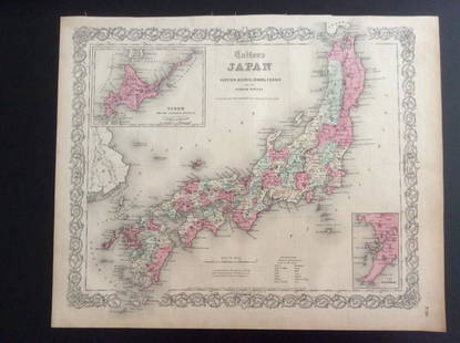
Ortelius: First Map of Japan in European Atlas, 1595
Similar Sale History
View More Items in Maps & AtlasesRelated Maps & Atlases
More Items in Maps & Atlases
View MoreRecommended Transportation & Travel Collectibles
View More


Item Details
Description
This landmark map was the first map of Japan published in a European atlas. Ortelius received the map from Ludovico Teixeira, a Portuguese Jesuit cartographer and mathematician. While Teixeira had not personally traveled to Japan, he obviously had access to Japanese sources as the map presents the first reasonably accurate and recognizable depiction of the island nation with numerous Japanese place names. Korea appears as an island tapering to a point labeled Punta dos ladrones. The map is elegantly embellished with three large galleons, two elaborate cartouches, and a boldly engraved border. This influential map was to become the basis for many other cartographers' maps of Japan for more than fifty years. Verso text: Latin, with page number 110, published in 1603.
Abraham Ortelius (1527 - 1598) was a Flemish cartographer & geographer, celebrated as the creator of the first modern atlas, the Theatrum Orbis Terrarum (Theatre of the World). Ortelius' work, the Theatrum Orbis Terrarum, was the first uniformly sized, systematic collection of maps; this work can therefore be called the first atlas (although the term was not used until 20 years later by Mercator).
Please note that this lot has a confidential reserve. When you leave a bid in advance of the auction, submit your maximum. Jasper52 will bid on your behalf as much as necessary to ensure that you meet the reserve price or that you remain in the lead, up to your maximum. The bidder who has submitted the highest bid wins the lot, provided the bid exceeds the reserve price.
Shipping:
Authenticity:
Photos, descriptions, and estimates were prepared with the utmost care by a fully certified expert and appraiser. All items in this sale are guaranteed authentic. Please contact us if there is a misrepresentation so that the item can be returned.
Your purchase is protected:
In the rare event that your purchase from this auction does not meet your expectations, Jasper52 specialists are here to help. If the item did not conform to the lot description in the sale, U.S. buyers may return the item for a full refund provided you notify Jasper52 within 5 days of receiving the item.
Condition
VG+. A crisp impression on watermarked paper with a light vertical crease adjacent to the centerfold and some minor surface soil.
Buyer's Premium
- 10%
Ortelius: First Map of Japan in European Atlas, 1595
Estimate $2,400 - $2,700
17 bidders are watching this item.
Shipping & Pickup Options
Item located in California, USSee Policy for Shipping
Payment
Accepts seamless payments through LiveAuctioneers
See More Items From This Jasper52 Seller

Auction Curated By

Maps Expert
TOP


![Amér Sep Grandes Antilles 73 Jamaica Pedro Bank San Andrés VANDERMAELEN 1827 map: CAPTION PRINTED BELOW PICTURE: Amér. Sep. - Grandes Antilles [Ile Jamaïque] - No. 73 The map covers the Caribbean Sea between the southern coast of Jamaica, the Pedro Bank & Cays, and the Co](https://p1.liveauctioneers.com/5584/327764/176591209_1_x.jpg?height=310&quality=70&version=1714507756)
![Amér. Sep. Ile de Cuba #67. Cuba & Jamaica Cayman Islands. VANDERMAELEN 1827 map: CAPTION PRINTED BELOW PICTURE: Amér. Sep. - Ile de Cuba [Ile de Cuba] - No. 67 The map covers most of Cuba and Jamaica, and the Cayman Islands. Inset is a description of the island of Cuba DATE P](https://p1.liveauctioneers.com/5584/327764/176590762_1_x.jpg?height=310&quality=70&version=1714507756)


![[Maps] Martin Zeiler, Itinerarium Italiae, 1640: [Maps] Martin Zeiler, Itinerarium Italiae, 1640, Martini Zeilleri. Itinerarium Italiae Nov-Antiquae: oder, Raiss-Beschreibung durch Italien, Matthaus Merian, Frankfurt, 40 plates, most double-page, in](https://p1.liveauctioneers.com/188/326797/176317459_1_x.jpg?height=310&quality=70&version=1713847031)


![[Maps] Gio. Ant. Magnini, Italia, 1620: [Maps] Gio. Ant. Magnini, Italia, 1620, Giovanni Antonio Magnini. Italia, data in luce da Fabio suo figliuolo al Serenissimo Ferdinado Gonzaga Duca di Matoua edi Monserrato etc. Bologna, for Sebastian](https://p1.liveauctioneers.com/188/326797/176317457_1_x.jpg?height=310&quality=70&version=1713847031)


