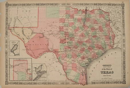
Johnson’s New Map of the State of Texas, 1863
Similar Sale History
Recommended Items


Item Details
Description
Johnson’s New Map of the State of Texas, 1863. Lithographed map with hand coloring. 26.25 x 18; This is a superior copy, with strong lines and vivid color. Only faults are the extreme corners of the paper are missing (won’t show when matted). Inset maps of Sabine Lake, Northern Texas, and Galveston Bay. Published during the midst of the American Civil War. Western Texas consists of El Paso, Bexar, and Presidio territories. The map shows many military installations, including Fort Duncan and Phantom Hill. The Fort Ewell Rifles Military Station is identified in southern Texas. "German Settlements", "Indian Reserve", "Wichita Village", and "Wells Road" locations are noted. Topographical features such as rivers, springs, mountains, and the Cross Timbers are all identified. Striking large format map of Texas colored by counties with large insets of the northern panhandle, Galveston and Sabine Lake. Map reflects the relative expansion of the counties of Texas, with more or less the current configurations in the east but overall very few in the West. Shows towns, railroads (actual and proposed), stations, lakes, rivers, and important early roads and explorer routes. Some of the Miltary Outposts and Indian information also shown. Terrific map of Texas during the Civil War.
Please note that this lot has a confidential reserve. When you leave a bid in advance of the auction, submit your maximum. Jasper52 will bid on your behalf as much as necessary to ensure that you meet the reserve price or that you remain in the lead, up to your maximum. The bidder who has submitted the highest bid wins the lot, provided the bid exceeds the reserve price.
Shipping:Domestic: Flat-rate of $7.50 to anywhere within the contiguous U.S. International: Foreign shipping rates are determined by destination. Location: This item ships from Ohio.
Authenticity:
Photos, descriptions, and estimates were prepared with the utmost care by a fully certified expert and appraiser. All items in this sale are guaranteed authentic. Please contact us if there is a misrepresentation so that the item can be returned.
Your purchase is protected:
In the rare event that your purchase from this auction does not meet your expectations, Jasper52 specialists are here to help. If the item did not conform to the lot description in the sale, U.S. buyers may return the item for a full refund provided you notify Jasper52 within 5 days of receiving the item.
Please note that this lot has a confidential reserve. When you leave a bid in advance of the auction, submit your maximum. Jasper52 will bid on your behalf as much as necessary to ensure that you meet the reserve price or that you remain in the lead, up to your maximum. The bidder who has submitted the highest bid wins the lot, provided the bid exceeds the reserve price.
Shipping:
Authenticity:
Photos, descriptions, and estimates were prepared with the utmost care by a fully certified expert and appraiser. All items in this sale are guaranteed authentic. Please contact us if there is a misrepresentation so that the item can be returned.
Your purchase is protected:
In the rare event that your purchase from this auction does not meet your expectations, Jasper52 specialists are here to help. If the item did not conform to the lot description in the sale, U.S. buyers may return the item for a full refund provided you notify Jasper52 within 5 days of receiving the item.
Buyer's Premium
- 10%
Johnson’s New Map of the State of Texas, 1863
Estimate $450 - $600
10 bidders are watching this item.
Shipping & Pickup Options
Item located in Ohio, USSee Policy for Shipping
Payment
Accepts seamless payments through LiveAuctioneers
See More Items From This Jasper52 Seller

Related Searches
TOP


![Johnson's New York Maps [New York State, NYC]: Two Johnson's New York Maps, one of New York City and Brooklyn, the other of New York State. Alvin Jewett Johnson Cartographer. Published by A. J. Johnson, New York. Stamped 'Entered according to Act](https://p1.liveauctioneers.com/5755/154409/77936949_1_x.jpg?height=310&quality=70&version=1573094011)


![[PICTORIAL MAPS – TRAVEL]. Three Pictorial Maps. 1940s/50s....: [PICTORIAL MAPS – TRAVEL]. Three Pictorial Maps. 1940s/50s. Three brochure sized foldout maps designed for travel including: Highroads to Happiness. Mexico City: Pemex Travel Club, ca. 1940s. &#](https://p1.liveauctioneers.com/928/325952/175495561_1_x.jpg?height=310&quality=70&version=1712935174)


