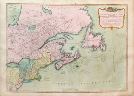
Highly important map of Canada and the Great Lakes
Similar Sale History
View More Items in Maps & AtlasesRelated Maps & Atlases
More Items in French Maps & Atlases
View MoreRecommended Transportation & Travel Collectibles
View More


Item Details
Description
Le Canada faict par le Sr. de Champlain. ou sont La Nouvelle France, La Nouvelle Angleterre, La Nouvelle Holande, La Nouvelle Suede, La Virginie &c... Pierre Du Val (1619-1683). Engraved map. 5th State. Paris: 1670 ca. 21 1/2 x 14 inches sheet, 28 1/4 x 34 1/2 inches framed. Highly important map of Canada, the Great Lakes and Northeastern United States, originally engraved for Samuel de Champlain's 1619 Les Voyages.
Buyer's Premium
- 25%
Highly important map of Canada and the Great Lakes
Estimate $12,000 - $15,000
3 bidders are watching this item.
Shipping & Pickup Options
Item located in New York, NY, usSee Policy for Shipping
Payment

Related Searches
TOP


![Manuscript Map of Givet, France on the Belgian Border: [Givet, France]. "Charlemont les deux Givets et la Couronne d'Haurs Pour servir au Projet de mil Sept cent trente sept" Fine manuscript plan in ink and colours on paper (no visible watermark), scale a](https://p1.liveauctioneers.com/1968/273926/143704769_1_x.jpg?height=310&quality=70&version=1672435208)


![Early French Map of Great Lakes [179300]: Early French (circa 1780s) map of the Great Lakes region and parts of Canada. Map, a double truck page from a book, measures 9"x 13" and shows the various Indian tribes in the area, including the Algo](https://p1.liveauctioneers.com/2699/331495/178785744_1_x.jpg?height=310&quality=70&version=1717094933)


![French Map of America Southeast [179304]: Northeastern American map published 1788 from a French cartographer. Map measures 9"x 13". Published during America's War of Independence from Great Britain (1176-1783), this map features the mid-Atla](https://p1.liveauctioneers.com/2699/331495/178785746_1_x.jpg?height=310&quality=70&version=1717094933)
![Map of Great Lakes, c1850's [180162]: Antique map of the Great Lakes, Ohio, Indiana, Illinois, Wisconsin, and Michigan. Colored legend indicating Townships ranges. Inset of the World Hemispheres divided by western and eastern. C 1850's, F](https://p1.liveauctioneers.com/2699/331495/178785780_1_x.jpg?height=310&quality=70&version=1717094933)


![Mining Districts-Sketch Gen. Reilly's Route 1849 [178901]: Sketch of Gen. Reilly's Route-Mining Districts, July and August 1849. Copied from the original sketch by Lieut. Derby in the office of the 10th military department by J Hollingsworth. Ackerman's litho](https://p1.liveauctioneers.com/2699/331495/178785791_1_x.jpg?height=310&quality=70&version=1717094933)


![[MAPS]. HOMANN, Johann Baptist, HOMANN HEIRS, and Georg Matthäus SEUTTER. [Composite Atlas].: [MAPS]. HOMANN, Johann Baptist (1663-1724), HOMANN HEIRS, and Georg Matthäus SEUTTER (1678-1757). [Composite Atlas]. [Nuremberg, Augsburg, and others: Homann Heirs and others, maps dated between](https://p1.liveauctioneers.com/197/329395/177650530_1_x.jpg?height=310&quality=70&version=1715364962)


