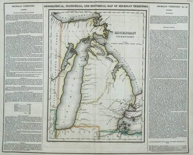
Early Map of The Michigan Territory by Carey
Similar Sale History
View More Items in Maps & AtlasesRelated Maps & Atlases
More Items in American Maps & Atlases
View MoreRecommended Transportation & Travel Collectibles
View More


Item Details
Description
The Upper Territories of the United States, 1814. Matthew Carey (1760-1839). Engraved map with original hand color in outline. Philadelphia, 1814. 22 x 17 1/4 inches sheet. The map reflects a very early appearance of The Michigan Territory (organized 1805), which had not yet appeared separately on any map. The Upper Peninsula was still not part of the Territory. Similarly, the appearance of Illinois (organized in 1809) and Indiana (organized 1800), are among the earliest on a map.
Buyer's Premium
- 25%
Early Map of The Michigan Territory by Carey
Estimate $300 - $600
4 bidders are watching this item.
Shipping & Pickup Options
Item located in New York, NY, usSee Policy for Shipping
Payment

Related Searches
TOP


![Jansson's important early map of New England: [MAP-NORTH AMERICA] JANSSON, JAN. Nova Belgica et Anglia Nova. Amsterdam: circa 1646. Latin text on verso. Neat lines 15 1/4 x 19 3/4 inches (38.7 x 50.5 cm). Marginal tears r](https://p1.liveauctioneers.com/292/326828/175962856_1_x.jpg?height=310&quality=70&version=1713473479)


![Parker's map of Oregon 1838: Heading: Author: Title: Parker, Samuel Place Published: Map of Oregon Territory Publisher:[Ithaca, NY] Date Published: Description: 1838Copper-engraved folding map. 34.7x58.8 cm](https://p1.liveauctioneers.com/642/326037/175553831_1_x.jpg?height=310&quality=70&version=1713477451)
![Memoir to accompany Missip.-Pacific Map: Heading: Author: Warren, Gouverneur K. Title: Memoir to Accompany the Map of the Territory of the United States from the Mississippi River to the Pacific Ocean Place Published: [Washington, D.C.] Pub](https://p1.liveauctioneers.com/642/326037/175553704_1_x.jpg?height=310&quality=70&version=1713477451)


