


1885 -1886 Railroad Map and Business Guide NY Booklet
Similar Sale History
View More Items in Maps & Atlases


![Railroad Map of the United States: [America, East Coast] Ensign, Bridgman and Fanning's Railroad Map of the United States showing the Depots & Stations. Engraved map with original hand color. Engraved by W. S. Barnard. New York, 1856.](https://p1.liveauctioneers.com/1968/203922/103366115_1_x.jpg?height=310&quality=70&version=1620913733)


![Mitchell Map of Western U.S.: *** START PRICE IS THE RESERVE *** [America] MITCHELL, Samuel Augustus (1792-1868). A New Map of Texas, Oregon and California with the Regions Adjoining. Engraving with original hand color, with origi](https://p1.liveauctioneers.com/1968/163248/82424595_1_x.jpg?height=310&quality=70&version=1583340284)


![Map of U.S., 1846: *** START PRICE IS THE RESERVE *** [America] HAVEN & EMMERSON. Map of the United States and Mexico Including Oregon, Texas and the Californias. Engraved map with original hand color. New York, 1846. 1](https://p1.liveauctioneers.com/1968/163248/82424576_1_x.jpg?height=310&quality=70&version=1583340284)
Related Maps & Atlases


![Large Map of Alaska: Large Map of Alaska With map of Washington and Oregon [separately] on versos Cartographer: George Franklin Cram Dated: Circa 1900 Type: Color Lithograph Dimensions: 14](https://p1.liveauctioneers.com/5614/330257/178045317_1_x.jpg?height=310&quality=70&version=1716032806)

![Large Map of Hawaiian Islands & Porto Rico: Large Map of Porto Rico With map of Hawaii - Hawaiian Islands and Samoa [separately] on versos] Cartographer: George Franklin Cram Dated: Circa 1900 Type: Color Lithograph](https://p1.liveauctioneers.com/5614/330257/178045318_1_x.jpg?height=310&quality=70&version=1716032806)
![Large Map of Texas (Western Part): Large Map of Texas (Western Part) With map of Louisiana and Arkansas [separately] on versos Cartographer: George Franklin Cram Dated: Circa 1900 Type: Color Lithograph Dime](https://p1.liveauctioneers.com/5614/330257/178045313_1_x.jpg?height=310&quality=70&version=1716032806)

![Large Map of Montana: Large Map of Montana With map of Utah and Wyoming [separately] on versos Cartographer: George Franklin Cram Dated: Circa 1900 Type: Color Lithograph Dimensions: 14 1/2](https://p1.liveauctioneers.com/5614/330257/178045315_1_x.jpg?height=310&quality=70&version=1716032806)
![Large Map of California: Large Map of California With map of Arizona and Nevada [separately] on versos Cartographer: George Franklin Cram Dated: Circa 1900 Type: Color Lithograph Dimensions: 14](https://p1.liveauctioneers.com/5614/330257/178045314_1_x.jpg?height=310&quality=70&version=1716032806)
![Large Map of Texas (Eastern Part): Large Map of Texas (Eastern Part) With map of Alabama and Mississippi [separately] on versos Cartographer: George Franklin Cram Dated: Circa 1900 Type: Color Lithograph Dim](https://p1.liveauctioneers.com/5614/330257/178045312_1_x.jpg?height=310&quality=70&version=1716032806)
![Large Map of Kentucky and Tennessee: Large Map of Kentucky and Tennessee With map of North Dakota and South Dakota [separately] on versos Cartographer: George Franklin Cram Dated: Circa 1900 Type: Color Lithograph](https://p1.liveauctioneers.com/5614/330257/178045311_1_x.jpg?height=310&quality=70&version=1716032806)
![Large Map of Michigan and Wisconsin: Large Map of Michigan and Wisconsin With map of Kansas and Nebraska [separately] on versos Cartographer: George Franklin Cram Dated: Circa 1900 Type: Color Lithograph Dimen](https://p1.liveauctioneers.com/5614/330257/178045309_1_x.jpg?height=310&quality=70&version=1716032806)


More Items in American Maps & Atlases
View More


Recommended Transportation & Travel Collectibles
View More


Item Details
Description
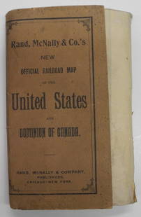
1885 1886 Railroad Map and Business Guide in Book Form This is an intact copy of the advertising map printed for use in the years 1885 to the year 1886. The map show most of the continental United States , with Dakota as a territory , not yet divided into North and South. The area that would become Oklahoma is listed as Indian Territory and the state of Texas is written as \\\" TEXA EXAS \\\" . The map covers from Maine to the Florida - Georgia line and west to New Mexico and Colorado with two areas of enlarged detail, one is of the \\\" Vicinity of Boston\\\" and the other is of the \\\" Vicinity of New York and Philadelphia\\\" . Advertising around the edge of the map side is primarily from the Utica N.Y. region with the \\\" Compliments of \\\" portion left blank where a merchant would have placed there name and information.. The reverse side of the map contains a price guide for Railroad passengers from N.Y.C. to Albany, N.Y. through Toronto , Canada and many points in between. Advertiser are listed on this side in order by major New York towns and cities including: Utica, Rome, Camden, New York Mills, Clinton, Mohawk, Herkimer, Canajoharie, Amsterdam and Schenectady. The words \\\" 19 E. Dominick Street Rome NY have been inked onto the advert for Brodock Soap Manufacturing , the writing is very neatly done and of a style and age to match the age of the map. The whole map fold into a red paper over cardboard style set of covers for safe keeping that measures 9 1/4 inch by 4 1/2 inch. The map when unfolded measures 26 inches by 40 1/2 inches. Cover condition is good, showing advertising still boldly printed on red paper with wear and rubbing to corners and edges. The map has a 1 inch seam split at the base of Lake Michigan and another approx 2 1/2 inch seam split at the eastern edge of Nebraska.
Condition
See description & images
Buyer's Premium
- 13%
1885 -1886 Railroad Map and Business Guide NY Booklet
Estimate $150 - $400
3 bidders are watching this item.
Shipping & Pickup Options
Item located in Accord, NY, usSee Policy for Shipping
Payment

TOP