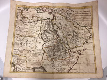
Victor Lavasseur. Map of Egypt Abyssinia Nubia. 1830.
Similar Sale History
View More Items in Maps & AtlasesRelated Maps & Atlases
More Items in Maps & Atlases
View MoreRecommended Transportation & Travel Collectibles
View More


Item Details
Description
Print of hand colored steel engraving titled Egypte Nubie Abyssinie“.
Author Victor Lavasseur.
Engraved by unknown.
From Atlas classique universel de Geographie anciene et moderne“ by Victor Levasseur. Paris. 1830.
Victor Levasseur (1800–1870) was a French cartographer widely known for his distinctive decorative style. He produced numerous maps more admired for the artistic content of the scenes and data surrounding the map than for the detail of the map.
Egypt officially the Arab Republic of Egypt, is a transcontinental country spanning the northeast corner of Africa and southwest corner of Asia, via a land bridge formed by the Sinai Peninsula. It is the world\'s only contiguous Eurafrasian nation and most of Egypt\'s territory of 1,010,408 square kilometres (390,000 sq mi) lies within the Nile Valley. It is a Mediterranean country and is bordered by the Gaza Strip and Israel to the northeast, the Gulf of Aqaba to the east, the Red Sea to the east and south, Sudan to the south and Libya to the west.
The Ethiopian Empire also known as Abyssinia, spanned a geographical area covered by present-day Eritrea and the northern half of Ethiopia. It existed from approximately 1137 (beginning of Zagwe Dynasty) until 1974 when the monarchy was overthrown in a coup d\'tat.
Nubia is a region along the Nile river located in what is today northern Sudan and southern Egypt. One of the earliest civilizations of ancient Northeastern Africa, with a history that can be traced from at least 2000 B.C. onward through Nubian monuments and artifacts as well as written records from Egypt and Rome, it was home to one of the African empires. There were a number of large Nubian kingdoms throughout the Postclassical Era, the last of which collapsed in 1504, when Nubia became divided between Egypt and the Sennar sultanate resulting in the Arabization of much of the Nubian population. Nubia was again united within Ottoman Egypt in the 19th century, and within Anglo-Egyptian Sudan from 1899 to 1956.
Approx. image size 12, 1 x 8, 6/13, 9 x 10 cm.Condition: good.
Condition
Condition: good.
Buyer's Premium
- 0%
Victor Lavasseur. Map of Egypt Abyssinia Nubia. 1830.
Estimate €7 - €9
Shipping & Pickup Options
Item located in Vilnius, ltSee Policy for Shipping
Payment

Related Searches
TOP


![Hondius Map of Morocco: HONDIUS, Jodocus (1563-1612) / MERCATOR, Gerard (1512-1594). [Morocco] Fessae et Marocchi Regna. Engraving with original hand color. Amsterdam, c. 1606 or later. 17 3/4" x 21" sheet. Comparable: Old W](https://p1.liveauctioneers.com/1968/169571/85465312_1_x.jpg?height=310&quality=70&version=1590242353)


![[Maps] Gio. Ant. Magnini, Italia, 1620: [Maps] Gio. Ant. Magnini, Italia, 1620, Giovanni Antonio Magnini. Italia, data in luce da Fabio suo figliuolo al Serenissimo Ferdinado Gonzaga Duca di Matoua edi Monserrato etc. Bologna, for Sebastian](https://p1.liveauctioneers.com/188/326797/176317457_1_x.jpg?height=310&quality=70&version=1713847031)
![[Maps] Martin Zeiler, Itinerarium Italiae, 1640: [Maps] Martin Zeiler, Itinerarium Italiae, 1640, Martini Zeilleri. Itinerarium Italiae Nov-Antiquae: oder, Raiss-Beschreibung durch Italien, Matthaus Merian, Frankfurt, 40 plates, most double-page, in](https://p1.liveauctioneers.com/188/326797/176317459_1_x.jpg?height=310&quality=70&version=1713847031)


