French version of Jefferson-Fry Virginia Map
Similar Sale History
Recommended Items


Item Details
Description
Heading:
Author: Robert de Vaugondy, Gilles and Didier
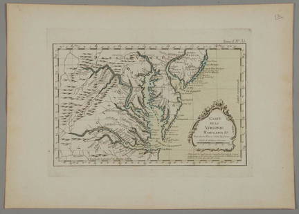
Title: Carte De La Virginie Et Du Maryland Dressée sur la grande carte Angloise de Mrs. Josué Fry et Pierre Jefferson
Place Published: Paris
Publisher:
Date Published: 1755
Description:
Author: Robert de Vaugondy, Gilles and Didier
Title: Carte De La Virginie Et Du Maryland Dressée sur la grande carte Angloise de Mrs. Josué Fry et Pierre Jefferson
Place Published: Paris
Publisher:
Date Published: 1755
Description:
Engraved map, outline color. First state (of five).
French edition of the Fry-Jefferson map, considered one of the most important 18th century maps of the region. Due to the rarity and high value of the four-sheet English version of the Fry-Jefferson map, the first state of the single-sheet French version is the earliest obtainable map to accurately depict the interior of Virginia beyond the Tidewater. The present example is first state with the Limites du Lord Fairfax delineating the Fairfax Grant in Virginia's Northern Neck and the vast region northwest of it. The signature of the engraver, Elisabeth Haussard, is below the cartouche.
Provenance: Altman's, 8/65
Condition
A bit of darkening along centerfold, ill-crease at the bottom, a few verso tape repairs, a tiny brown spot; very good or better.
Buyer's Premium
- 23%
French version of Jefferson-Fry Virginia Map
Estimate $2,000 - $3,000
4 bidders are watching this item.
Shipping & Pickup Options
Item located in San Francisco, CA, usSee Policy for Shipping
Payment

Related Searches
TOP


![[Map] Virginia and Florida, 17th c.: Jannson, Jan. "Virginiae partis australis, et Floridae partis orientalis…." Circa 1640s. Measuring from plate-marks 50.5 x 39cm. Hand-colored. Verso with French text, old stub affixed to crease, and](https://p1.liveauctioneers.com/3532/146911/74242490_1_x.jpg?height=310&quality=70&version=1564368564)


![Nova Virginia Tabula. [1671 or later].: [Virginia] NOVA VIRGINIAE TABULA. Derived from the Hondius-Blaeu version of John Smith’s map. Oriented to the West. Tooley’s Derivative 8, State 1: Cartouche at upper left with no imprint. “Nota](https://p1.liveauctioneers.com/179/93063/47518642_1_x.jpg?height=310&quality=70&version=1472482862)


![HAND COLORED MAP OF PERU & COUNTRY OF THE AMAZONS, 1747, BY EMANUEL BOWEN, FRAMED: A New And Accurate Map Of Peru And The Country Of The Amazones. Drawn From The Most Authentick French Maps &C. And Regulated By Astronomical Observations, London]: William Innys [et al.], 1747. A deta](https://p1.liveauctioneers.com/957/328836/177180798_1_x.jpg?height=310&quality=70&version=1715021458)
