


Similar Sale History
View More Items in Maps & Atlases


Item Details
Description
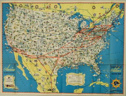
This large wall map is a great example of charts published by railroad companies to promote their business. The map covers the western United States from Lake Michigan and Alabama in minute detail. It shows all the railroads including small feeder lines, train stations, roads, highways, national parks and monuments, rivers, lakes. towns, etc. Published by the Chicago, Burlington, & Quincy Railroad Co.
Reserve: $90.00
Shipping:
Your purchase is protected:
Photos, descriptions, and estimates were prepared with the utmost care by a fully certified expert and appraiser. All items in this sale are guaranteed authentic.
In the rare event that the item did not conform to the lot description in the sale, Jasper52 specialists are here to help. Buyers may return the item for a full refund provided you notify Jasper52 within 5 days of receiving the item.
Condition
Fair. A number of splits alond the edges. Some closed. Colored.
Buyer's Premium
- 15%
1940 Map of the US West - Burlington Route
$90.00
$150
1 bidder is watching this item.
Shipping & Pickup Options
Item located in Ohio, US$38 shipping in the US
Payment
Accepts seamless payments through LiveAuctioneers
See More Items From This Jasper52 Seller


![1878 Mitchell Map of Washington, Oregon, Idaho, much of Montana [verso] Territory of Idaho: Title: 1878 Mitchell Map of Washington, Oregon, Idaho, much of Montana [verso] Territory of Idaho Cartographer: S Mitchell Year / Place: 1878, Philadelphia Map Dimension (in.): 10.8 X 13.4 in. This is](https://p1.liveauctioneers.com/5584/329422/177662232_1_x.jpg?height=310&quality=70&version=1715717898)
![1892 Cowles Civil War Map of Battles in Gettysburg, Virginia, W Virginia and Maryland -- Sketch of: Title: 1892 Cowles Civil War Map of Battles in Gettysburg, Virginia, W Virginia and Maryland -- Sketch of the battle of McDowell, VA. [and] Route Map of Gettysburg Campaign Lt-Gen T.J. Jackson [and] S](https://p1.liveauctioneers.com/5584/329422/177662185_1_x.jpg?height=310&quality=70&version=1715717898)


![[MAP]. TODESCHI, Pietro. [Nova et Acurata Totius Americae Tabula auct. G.I. Blaeu] America quarta: [MAP]. TODESCHI, Pietro. [Nova et Acurata Totius Americae Tabula auct. G.I. Blaeu] America quarta pars orbis quam plerunq, nuvum orbem appellitant primo detecta est anno 1492 a Christophoro Columbo...](https://p1.liveauctioneers.com/197/329395/177650542_1_x.jpg?height=310&quality=70&version=1715364962)


![[MAPS]. HOMANN, Johann Baptist, HOMANN HEIRS, and Georg Matthäus SEUTTER. [Composite Atlas].: [MAPS]. HOMANN, Johann Baptist (1663-1724), HOMANN HEIRS, and Georg Matthäus SEUTTER (1678-1757). [Composite Atlas]. [Nuremberg, Augsburg, and others: Homann Heirs and others, maps dated between](https://p1.liveauctioneers.com/197/329395/177650530_1_x.jpg?height=310&quality=70&version=1715364962)


TOP