Geography. ALBERTI. Descrittione di tutta Italia.
Similar Sale History
View More Items in Books, Magazines & Papers


Related Books, Magazines & Papers
More Items in Books, Magazines & Papers
View MoreRecommended Collectibles
View More


Item Details
Description
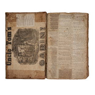
ALBERTI, Leandro. Descrittione di tutta Italia. Venezia, Salicato, 15884to, 198x145 mm. Legatura piena pelle del ‘700. Carte 34 nn., 495 num, 1 c. bianca; 100 num., 5 nn di index. 7 carte di tavola a doppia pagina. Doppio frontespizio con marca tipografica incisa, capolettera xilografati. Ex libris araldico “Fechenbach” incollato al contropiatto. Monogramma di precedente proprietario sul Frontespizio. Lievi abrasioni alla legatura, internamente alcune bruniture e tracce d’uso, buon esemplare. Rara edizione figurata. L’opera, in questa edizione accresciuta con l’aggiunta delle "Isole", costituisce una importante raccolta di materiale e sarà particolarmente utilizzata nello sviluppo successivo della scienza geografica e geopolitica. Le carte geografiche rappresentano Corsica, Sardegna, Sicilia, isole Tremiti, arcipelago toscano, arcipelago pontino e isole del golfo di Napoli. In fine bella veduta a volo d'uccello di Venezia considerata come un'isola. La carta della Corsica è una delle prime stampate. Solo le edizioni del 1567 e la presente presentano la sezione cartografica, che viene proposta nel mercato anche separatamente.Adams A 477; BM, STC Italian 14, Cremonini 5; Cicognara 4129 (Ediz. del 1550).
Condition
4to, 198x145 mm. Full calf binding of XVIII century. Leaves [34], 495, 1 leaf blank; 100 numbered leaves, 5 of Index. 7 double page plates. Double titlepage with engraved printer’s mark, woodcut initial letters. Araldic ex-libris “Fechenbach” glued on the inside cover. Monogram of previous owner on titlepage. Slight rubbed binding, internally some brownings and signs of wear; good copy.
Rare illustrated edition. The work, in this edition enlarged with the addition of the "Islands", constitutes an important collection of material and will be particularly used in the subsequent development of geographical and geopolitical science. The geographical maps represent Corsica, Sardinia, Sicily, the Tremiti islands, the Tuscan archipelago, the Pontine archipelago and the islands in the Gulf of Naples. At the end, a beautiful bird's eye view of Venice considered as an island. The Corsican map is one of the first printed. Only the editions of 1567 and this one presents the cartographic section, which is also offered on the market separately.
Rare illustrated edition. The work, in this edition enlarged with the addition of the "Islands", constitutes an important collection of material and will be particularly used in the subsequent development of geographical and geopolitical science. The geographical maps represent Corsica, Sardinia, Sicily, the Tremiti islands, the Tuscan archipelago, the Pontine archipelago and the islands in the Gulf of Naples. At the end, a beautiful bird's eye view of Venice considered as an island. The Corsican map is one of the first printed. Only the editions of 1567 and this one presents the cartographic section, which is also offered on the market separately.
Buyer's Premium
- 30%
Geography. ALBERTI. Descrittione di tutta Italia.
Estimate €2,000 - €3,000
1 bidder is watching this item.
Get approved to bid.
Shipping & Pickup Options
Item located in Padova, ITALY, itOffers In-House Shipping
Payment

Related Searches
TOP


![LUDOVICO ARIOSTO (1474 - 1533): Orlando Furioso di M. Lodovico Ariosto. Tomo I. [IV.]. Venezia,: LUDOVICO ARIOSTO (1474 - 1533) Orlando Furioso di M. Lodovico Ariosto. Tomo I. [IV.]. Venezia, presso Antonio Zatta, 1772-3 § 4to, Four volumes. I: [16], LX, 300 pp., [21] leaves of plates, sign.:](https://p1.liveauctioneers.com/3741/249316/129404703_1_x.jpg?height=310&quality=70&version=1653319019)
![[Counsels] Di Castro, 1617, 3 vols: RARE GIUNTINE EDITION OF DI CASTRO’S COUNSELSWITH A BINDING FROM A MEDIEVAL MANUSCRIPT ONLY A COPY IN WORLDWIDE PUBLIC LIBRARIES DI CASTRO, PAOLO. Consiliorvm sive responsorvm [...] cvivs haec omni](https://p1.liveauctioneers.com/2198/81459/42269239_1_x.jpg?height=310&quality=70&version=1448567789)


![1665 LA JERUSALEMME LIBERATA di TORQUATO TASSO FULLY ILLUSTRATED antique: LA JERUSALEMME LIBERATA di TORQUATO TASSO CONLA VITA DI LUI.. di BARTOLOMEO BARBATO CON LE FIGURE DI RAME Inn Venetia, per Stefano Curti, n.d. [c.1665] Size 6.5 by 9" pp. [16] + 201 (of 209, 7 pages a](https://p1.liveauctioneers.com/5584/328415/176935075_1_x.jpg?height=310&quality=70&version=1715112425)


![George Washington Signed Discharge: Partly printed discharge document signed by George Washington, as Commander in Chief of the Armies of the United States. Newburgh, [New York], 4 January 1783. 1 page, ## x ## in. Undersigned by Washin](https://p1.liveauctioneers.com/7226/322253/173251475_1_x.jpg?height=310&quality=70&version=1710004847)
![[Ambrotype] Texas Confederate Soldier: Sixth plate ambrotype. Full leatherette case. Portrait of a possible Texas Confederate soldier. A silver star device was used to pin up the brim of his light-toned headgear, a look often seen in image](https://p1.liveauctioneers.com/7226/322253/173251509_1_x.jpg?height=310&quality=70&version=1710004847)


![Captured Bowie Knife w/ Period Note of Provenance: Captured Confederate D-hilt Bowie knife. [Kenansville, North Carolina]: [Louis Froelich factory]. With original metal and leather sheath with affixed period notes. First note with only remnants. Secon](https://p1.liveauctioneers.com/7226/325455/175169154_1_x.jpg?height=310&quality=70&version=1712370394)


