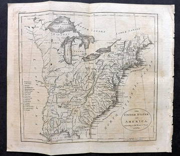
1783 Russell Map of the United States,
Similar Sale History
View More Items in Maps & Atlases
Related Maps & Atlases
More Items in Maps & Atlases
View MoreRecommended Transportation & Travel Collectibles
View More


Item Details
Description
map titled in oval cartouch 'A Map of the United States of America, According to the Treaty of Peace of 1783' and at the top 'Engraved for Gutheries new System of Geography', the map with boarders coloured, engraving 41.5cm x 37cm paper 44cm x 37cm A rare map dating back to around 1783, created by John Russell, showing the United States shortly after the conclusion of the American Revolutionary War. This map accurately reflects the territorial boundaries of the United States as defined by the 1783 Treaty of Paris, which marked the formal end of the war. The depicted borders stretch from the middle of the Great Lakes (excluding Michigan) in the north, extending southward to West Florida, and from the Mississippi River to the Atlantic Ocean in the east. Condition: generally good, old tape to top from frame mount John Russell created this map, and it was engraved by William Darton in Tottenham, situated in the northern part of London. It originally formed part of the 1785 edition of Guthrie's New System of Geography.
Buyer's Premium
- 30%
1783 Russell Map of the United States,
Estimate £300 - £500
11 bidders are watching this item.
Shipping & Pickup Options
Item located in Thatcham, Hampshire, ukOffers In-House Shipping
Local Pickup Available
Payment

TOP


![[PICTORIAL MAPS – TRAVEL]. Three Pictorial Maps. 1940s/50s....: [PICTORIAL MAPS – TRAVEL]. Three Pictorial Maps. 1940s/50s. Three brochure sized foldout maps designed for travel including: Highroads to Happiness. Mexico City: Pemex Travel Club, ca. 1940s. &#](https://p1.liveauctioneers.com/928/325952/175495561_1_x.jpg?height=310&quality=70&version=1712935174)


![[Maps] Gio. Ant. Magnini, Italia, 1620: [Maps] Gio. Ant. Magnini, Italia, 1620, Giovanni Antonio Magnini. Italia, data in luce da Fabio suo figliuolo al Serenissimo Ferdinado Gonzaga Duca di Matoua edi Monserrato etc. Bologna, for Sebastian](https://p1.liveauctioneers.com/188/326797/176317457_1_x.jpg?height=310&quality=70&version=1713847031)
![[Maps] Martin Zeiler, Itinerarium Italiae, 1640: [Maps] Martin Zeiler, Itinerarium Italiae, 1640, Martini Zeilleri. Itinerarium Italiae Nov-Antiquae: oder, Raiss-Beschreibung durch Italien, Matthaus Merian, Frankfurt, 40 plates, most double-page, in](https://p1.liveauctioneers.com/188/326797/176317459_1_x.jpg?height=310&quality=70&version=1713847031)


