


19th C. Colonial America Map
Similar Sale History
View More Items in Maps & Atlases


![[MAPS - COLONIAL NORTH AMERICA]. VAUGONDY, Gilles Robert de...: [MAPS - COLONIAL NORTH AMERICA]. VAUGONDY, Gilles Robert de (1688-1766). Partie de l'Amerique Septentrionale qui Compred le Cours de l'Ohio… Paris, 1755. Large hand-colored engraved map (520 x 6](https://p1.liveauctioneers.com/928/301544/160920952_1_x.jpg?height=310&quality=70&version=1694462960)


Related Maps & Atlases


![Les voyages de Rubruquis, Marco Polo, Jenkinson'. BELLIN/SCHLEY 1749 old map: CAPTION PRINTED BELOW PICTURE: Carte pour les Voyages de Rubruquis, Marco Polo, Jenkinson, &c [Map showing the explorations of William of Rubruck, Marco Polo, Anthony Jenkinson, &c.] Northern Asia: Si](https://p1.liveauctioneers.com/5584/329387/177649177_1_x.jpg?height=310&quality=70&version=1715717898)
![Royaumes de Siam, Tunquin, Pegu, Ava, Aracan'. Indochina. BELLIN 1751 old map: CAPTION PRINTED BELOW PICTURE: Carte des Royaumes de Siam, de Tunquin, Pegu, Ava, Aracan, &c [Map of the kingdoms of Siam, Tonkin, Pegu, Ava, Arakan, &c] DATE PRINTED: 1751 IMAGE SIZE: Approx 28.5 x 2](https://p1.liveauctioneers.com/5584/329387/177649212_1_x.jpg?height=310&quality=70&version=1715717898)


More Items in Maps & Atlases
View More


![[MAP]. TODESCHI, Pietro. [Nova et Acurata Totius Americae Tabula auct. G.I. Blaeu] America quarta: [MAP]. TODESCHI, Pietro. [Nova et Acurata Totius Americae Tabula auct. G.I. Blaeu] America quarta pars orbis quam plerunq, nuvum orbem appellitant primo detecta est anno 1492 a Christophoro Columbo...](https://p1.liveauctioneers.com/197/329395/177650542_1_x.jpg?height=310&quality=70&version=1715364962)


![[MAPS]. HOMANN, Johann Baptist, HOMANN HEIRS, and Georg Matthäus SEUTTER. [Composite Atlas].: [MAPS]. HOMANN, Johann Baptist (1663-1724), HOMANN HEIRS, and Georg Matthäus SEUTTER (1678-1757). [Composite Atlas]. [Nuremberg, Augsburg, and others: Homann Heirs and others, maps dated between](https://p1.liveauctioneers.com/197/329395/177650530_1_x.jpg?height=310&quality=70&version=1715364962)


Recommended Transportation & Travel Collectibles
View More


Item Details
Description
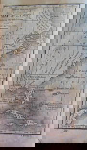
A 19th C. chirographical map of the province of New Yorkin North America. Engraved by Richard Pease, 1849. In a gilt wood frame. Mat opening: 37in tall x 27-1/2in wide. Frame: 52in tall x 45in wide. | Philadelphia Metro area delivery, NYC curbside delivery, and international third-party shipper information are all available on our website: BriggsAuction.com/Pickup.
Condition
Water spots, foxing. | All items are sold AS IS. Lot and condition details are for descriptive purposes only. Briggs Auction, Inc. is not responsible for errors and/or omissions of condition. The absence of a condition report does not imply that the lot is perfect or free from wear, flaws, or characteristics of age. Please bid according to your own expertise, or request any additional information and/or photographs you deem necessary.
Buyer's Premium
- 28%
19th C. Colonial America Map
Estimate $300 - $500
3 bidders are watching this item.
Get approved to bid.
Shipping & Pickup Options
Item located in Garnet Valley, PA, usSee Policy for Shipping
Local Pickup Available
Payment
Accepts seamless payments through LiveAuctioneers

TOP