


MAP, Canada, Weygand
Similar Sale History
View More Items in Maps & Atlases


Related Maps & Atlases


![d'Anville (Jean Baptiste Bourguignon) [Untitled Composite Atlas with 102 map sheets], [probably: d'Anville (Jean Baptiste Bourguignon) [Untitled Composite Atlas with 102 map sheets], comprising 20 double-page maps, 9 two-sheet double-page maps, 3 two-sheet maps on folding double-pages [Asia, Afri](https://p1.liveauctioneers.com/5458/329231/177514974_1_x.jpg?height=310&quality=70&version=1715269091)


More Items in Maps & Atlases
View More


![[MAP]. TODESCHI, Pietro. [Nova et Acurata Totius Americae Tabula auct. G.I. Blaeu] America quarta: [MAP]. TODESCHI, Pietro. [Nova et Acurata Totius Americae Tabula auct. G.I. Blaeu] America quarta pars orbis quam plerunq, nuvum orbem appellitant primo detecta est anno 1492 a Christophoro Columbo...](https://p1.liveauctioneers.com/197/329395/177650542_1_x.jpg?height=310&quality=70&version=1715364962)


![[MAPS]. HOMANN, Johann Baptist, HOMANN HEIRS, and Georg Matthäus SEUTTER. [Composite Atlas].: [MAPS]. HOMANN, Johann Baptist (1663-1724), HOMANN HEIRS, and Georg Matthäus SEUTTER (1678-1757). [Composite Atlas]. [Nuremberg, Augsburg, and others: Homann Heirs and others, maps dated between](https://p1.liveauctioneers.com/197/329395/177650530_1_x.jpg?height=310&quality=70&version=1715364962)


Recommended Transportation & Travel Collectibles
View More


Item Details
Description
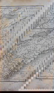
Labrador, Canada. F. Weygand, Neue und Verbesserte Carte von der Kuste von Labrador, from Beitraege zur Volker und Landerkunde, 1781 (published). Black & White. This is a highly detailed chart of the eastern coastline of Labrador showing the numerous inlets and islands. A rarely seen map, published in J. R. Forster and M. C. Sprengel's Beitraege zur Volker und Landerkunde.
Condition
A dark impression, issued folding on a lightly toned sheet with a coat of arms watermark with the motto "Spe et Fortuna." Grade: B+
Dimensions
14.1 x 11 in
Buyer's Premium
- 20% up to $5,000.00
- 15% above $5,000.00
MAP, Canada, Weygand
Estimate $600 - $750
Get approved to bid.
Shipping & Pickup Options
Item located in Richmond, VA, usOffers In-House Shipping
Local Pickup Available
Payment
Accepts seamless payments through LiveAuctioneers

TOP