


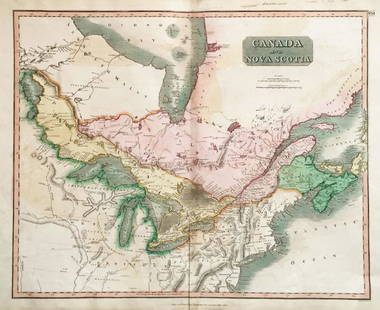
Geographical, Statistical & Historical Map Canada, 1823
Similar Sale History
View More Items in Maps & Atlases


Related Maps & Atlases


![Bouchette's monumental and rare wall map of Lower Canada: [WALL MAP-CANADA] BOUCHETTE, JOSEPH. To His Royal Highness George Augustus Frederick, Prince of Wales, Duke of Cornwall, Prince Regent of the United Kingdom of Great Britain & Ireland, this Topog](https://p1.liveauctioneers.com/292/326828/175962869_1_x.jpg?height=310&quality=70&version=1713473479)
![Memoir to accompany Missip.-Pacific Map: Heading: Author: Warren, Gouverneur K. Title: Memoir to Accompany the Map of the Territory of the United States from the Mississippi River to the Pacific Ocean Place Published: [Washington, D.C.] Pub](https://p1.liveauctioneers.com/642/326037/175553704_1_x.jpg?height=310&quality=70&version=1713477451)


![Mercator's map of China 1606: Heading: (China, Korea & Japan) Author: Mercator, Gerard Title: China Place Published: [Antwerp] Publisher: Date Published: [1606 - printed later] Description: Copper-engraved map,](https://p1.liveauctioneers.com/642/326037/175553816_1_x.jpg?height=310&quality=70&version=1713477451)
![A group of American prints, maps and graphics many in Perry Hopf frames: [CANADA-NATIVE AMERICANS] A group of miscellaneous prints, maps and graphics of mostly Canadian and Native American interest. A large group of about 19 items (all but one framed, most in fine Perry Ho](https://p1.liveauctioneers.com/292/326828/175962871_1_x.jpg?height=310&quality=70&version=1713473479)


More Items in Maps & Atlases
View More


Recommended Transportation & Travel Collectibles
View More


Item Details
Description
Uncommon map of Atlantic and Great Lakes portions of Canada. Multiple Indian nations are identified as well (Chippewa and major tribe of Algonquin, etc.). Major cities, lakes and rives are marked in this colorful copper engraved map. There is another version of this map that includes statistical details in the margins.
Please note that this lot has a reserve. When you leave a bid in advance of the auction, submit your maximum. Jasper52 will bid on your behalf as much as necessary to ensure that you meet the reserve price or that you remain in the lead, up to your maximum. The bidder who has submitted the highest bid wins the lot, provided the bid exceeds the reserve price.
Shipping:
Authenticity:
Photos, descriptions, and estimates were prepared with the utmost care by a fully certified expert and appraiser. All items in this sale are guaranteed authentic. Please contact us if there is a misrepresentation so that the item can be returned.
Your purchase is protected:
In the rare event that your purchase from this auction does not meet your expectations, Jasper52 specialists are here to help. If the item did not conform to the lot description in the sale, U.S. buyers may return the item for a full refund provided you notify Jasper52 within 5 days of receiving the item.
Condition
Very good. Slight age toning, mostly in issued centerfold and margins. Nicely colored and matted.
Buyer's Premium
- 10%
Geographical, Statistical & Historical Map Canada, 1823
Estimate $150 - $200
2 bidders are watching this item.
Shipping & Pickup Options
Item located in Ohio, USSee Policy for Shipping
Payment
Accepts seamless payments through LiveAuctioneers
See More Items From This Jasper52 Seller

TOP