


Extremité Meridionale de l'Amérique Tierra del Fuego Magellan Str BONNE 1788 map
Similar Sale History
View More Items in Maps & Atlases


![Mannevillette French Map of the Indian Ocean, 1753: D'APRES DE MANNEVILLETTE, Jean-Baptiste-Nicolas-Denis (1707-1780). [Indian Ocean] Carte Reduite de l'Ocean Oriental depuis le Cap de Bonne Esperance... Engraved map with original hand color in part. P](https://p1.liveauctioneers.com/1968/250616/130196497_1_x.jpg?height=310&quality=70&version=1654190895)


Related Maps & Atlases

![Entrée de Norton & Détroit de Bhering. Bering Strait Norton Sound BONNE 1790 map: TITLE/CONTENT OF MAP: [Cook 3e Voyage] Carte de l'entrée de Norton et du Détroit de Bhering, où l'on voit le Cap le plus Oriental de l'Asie et la pointe la plus Occidentale de l'Amé](https://p1.liveauctioneers.com/5584/326888/175994368_1_x.jpg?height=310&quality=70&version=1713903186)
![Entrée de Norton & Détroit de Bhering. Bering Strait Norton Sound BONNE 1788 map: TITLE/CONTENT OF MAP: [Cook 3e Voyage] Carte de l'entrée de Norton et du Détroit de Bhering, où l'on voit le Cap le plus Oriental de l'Asie et la pointe la plus Occidentale de l'Amé](https://p1.liveauctioneers.com/5584/326888/175994363_1_x.jpg?height=310&quality=70&version=1713903186)

![Isles de la Reine Charlotte. Nendo, Santa Cruz, Solomon Islands. BONNE 1790 map: TITLE/CONTENT OF MAP: [Voyage du Capitaine Carteret] Isles de la Reine Charlotte // Isle du Lord Egmont ou Nouvelle Grenesey // Isle de Carteret // Baye de L'Hirondelle // Havre de Byron [Voyage of Ca](https://p1.liveauctioneers.com/5584/326888/175994487_1_x.jpg?height=310&quality=70&version=1713903186)
![Isles de la Reine Charlotte. Nendo, Santa Cruz, Solomon Islands. BONNE 1788 map: TITLE/CONTENT OF MAP: [Voyage du Capitaine Carteret] Isles de la Reine Charlotte // Isle du Lord Egmont ou Nouvelle Grenesey // Isle de Carteret // Baye de L'Hirondelle // Havre de Byron [Voyage of Ca](https://p1.liveauctioneers.com/5584/326888/175994471_1_x.jpg?height=310&quality=70&version=1713903186)
![Carte des Isles des Amis. Friendly or Tonga Islands. Tongatapu. BONNE 1790 map: TITLE/CONTENT OF MAP: [Cook 3e Voyage] Carte des Isles des Amis // Plan du Havre de Tongataboo // Tabouai Island // Mangeea Island // Wateeoo Island [Cook's 3rd Voyage - Map of Friendly Islands (Tonga](https://p1.liveauctioneers.com/5584/326888/175994571_1_x.jpg?height=310&quality=70&version=1713903186)
![Carte des Isles des Amis. Friendly or Tonga Islands. Tongatapu. BONNE 1788 map: TITLE/CONTENT OF MAP: [Cook 3e Voyage] Carte des Isles des Amis // Plan du Havre de Tongataboo // Tabouai Island // Mangeea Island // Wateeoo Island [Cook's 3rd Voyage - Map of Friendly Islands (Tonga](https://p1.liveauctioneers.com/5584/326888/175994486_1_x.jpg?height=310&quality=70&version=1713903186)
![Isles de la Société. Society Islands. Huaheine Raiatea Polynesia. BONNE 1788 map: TITLE/CONTENT OF MAP: [Cook 3e Voyage] Carte des Isles de la Société // Isle de Noël // Havre d'Owarre dans Huaheine // Havre d'Oopoa dans Ulietea // Havre d'Ohamaneno dans Ulietea [Coo](https://p1.liveauctioneers.com/5584/326888/175994425_1_x.jpg?height=310&quality=70&version=1713903186)


![After De L'Ise's map of North America: [MAP-NORTH AMERICA] DE L'ISLE, GUILLAUME, after. L'Amerique Septentrionale Dressee sur les Observations de Mrs de l'Academie Royale des Sciences. Amsterdam: R.& J. Ottens, circa 1730 or later. Han](https://p1.liveauctioneers.com/292/326828/175962860_1_x.jpg?height=310&quality=70&version=1713473479)


More Items in Maps & Atlases
View More


Recommended Transportation & Travel Collectibles
View More


Item Details
Description
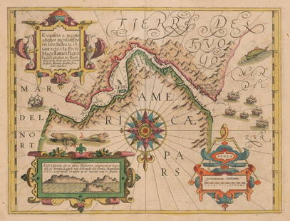
[Cook 2e Voyage] Extremité Meridionale de l'Amérique // Partie Est de la Terre de Feu, le Détroit de Le Maire et partie ouest de la terre des Etats // Canal de Noël // Suite de la Côte au Nord du Cap des Vierges // Isles du Nouvel An // Plan de la Baye du Bon Succès [Cook's 2nd Voyage - Southern extremity of America // Eastern part of Tierra del Fuego, the Le Maire Strait, and the western part of the Isla de los Estados // Christmas Sound // Continuation of the coast to the north of the Cape of
TITLE/CONTENT OF MAP: [Cook 2e Voyage] Extremité Meridionale de l'Amérique // Partie Est de la Terre de Feu, le Détroit de Le Maire et partie ouest de la terre des Etats // Canal de Noël // Suite de la Côte au Nord du Cap des Vierges // Isles du Nouvel An // Plan de la Baye du Bon Succès [Cook's 2nd Voyage - Southern extremity of America // Eastern part of Tierra del Fuego, the Le Maire Strait, and the western part of the Isla de los Estados // Christmas Sound // Continuation of the coast to the north of the Cape of Virgins (Cabo Virgenes) // Puerto Año Nuevo (New Year's Island) // Map of the Bay of Good Success (BahÃa Buen Suceso)]
DATE PRINTED: 1788
IMAGE SIZE: Approx 24.0 x 36.0cm, 9.5 x 14 inches (Large); Please note that this is a folding map.
TYPE: Antique 18th century copperplate map
CONDITION: Fair-to-Good: Toning along centrefold. Please note any other blemishes on the scan prior to purchasing this picture. Virtually all antiquarian maps and prints are subject to some normal aging due to use and time which is not obtrusive unless otherwise stated. We offer a no questions asked return policy.
AUTHENTICITY: This is an authentic historic map, published at the date stated above. It is not a modern copy.
VERSO: There is nothing printed on the reverse side, which is plain
FOLDING: This is a folding map.
ARTIST/CARTOGRAPHER/ENGRAVER: Rigobert Bonne
PROVENANCE: "Atlas Encyclopedique, contenant la géographie ancienne et quelques cartes sur la geographie du moyen age, la geographie moderne et les cartes relatives a la géographie physique", par M. Bonne, Ingenieur-Hydrographe de la Marine: et par M. Desmarest, de l'Academie Royale des Sciences, à Paris, Hôtel de Thou, Rue des Poitevins
Reserve: $60.00
Shipping:Domestic: Flat-rate of $30.00 to anywhere within the contiguous U.S. International: Foreign shipping rates are determined by destination. Combined shipping: Please ask about combined shipping for multiple lots before bidding. Location: This item ships from United Kigndom.
Your purchase is protected:
Photos, descriptions, and estimates were prepared with the utmost care by a fully certified expert and appraiser. All items in this sale are guaranteed authentic.
In the rare event that the item did not conform to the lot description in the sale, Jasper52 specialists are here to help. Buyers may return the item for a full refund provided you notify Jasper52 within 5 days of receiving the item.
TITLE/CONTENT OF MAP: [Cook 2e Voyage] Extremité Meridionale de l'Amérique // Partie Est de la Terre de Feu, le Détroit de Le Maire et partie ouest de la terre des Etats // Canal de Noël // Suite de la Côte au Nord du Cap des Vierges // Isles du Nouvel An // Plan de la Baye du Bon Succès [Cook's 2nd Voyage - Southern extremity of America // Eastern part of Tierra del Fuego, the Le Maire Strait, and the western part of the Isla de los Estados // Christmas Sound // Continuation of the coast to the north of the Cape of Virgins (Cabo Virgenes) // Puerto Año Nuevo (New Year's Island) // Map of the Bay of Good Success (BahÃa Buen Suceso)]
DATE PRINTED: 1788
IMAGE SIZE: Approx 24.0 x 36.0cm, 9.5 x 14 inches (Large); Please note that this is a folding map.
TYPE: Antique 18th century copperplate map
CONDITION: Fair-to-Good: Toning along centrefold. Please note any other blemishes on the scan prior to purchasing this picture. Virtually all antiquarian maps and prints are subject to some normal aging due to use and time which is not obtrusive unless otherwise stated. We offer a no questions asked return policy.
AUTHENTICITY: This is an authentic historic map, published at the date stated above. It is not a modern copy.
VERSO: There is nothing printed on the reverse side, which is plain
FOLDING: This is a folding map.
ARTIST/CARTOGRAPHER/ENGRAVER: Rigobert Bonne
PROVENANCE: "Atlas Encyclopedique, contenant la géographie ancienne et quelques cartes sur la geographie du moyen age, la geographie moderne et les cartes relatives a la géographie physique", par M. Bonne, Ingenieur-Hydrographe de la Marine: et par M. Desmarest, de l'Academie Royale des Sciences, à Paris, Hôtel de Thou, Rue des Poitevins
Reserve: $60.00
Shipping:
Your purchase is protected:
Photos, descriptions, and estimates were prepared with the utmost care by a fully certified expert and appraiser. All items in this sale are guaranteed authentic.
In the rare event that the item did not conform to the lot description in the sale, Jasper52 specialists are here to help. Buyers may return the item for a full refund provided you notify Jasper52 within 5 days of receiving the item.
Buyer's Premium
- 15%
Extremité Meridionale de l'Amérique Tierra del Fuego Magellan Str BONNE 1788 map
Estimate $70 - $80
1 bidder is watching this item.
Shipping & Pickup Options
Item located in United Kingdom$30 shipping in the US
Payment
Accepts seamless payments through LiveAuctioneers
See More Items From This Jasper52 Seller

Related Searches
TOP