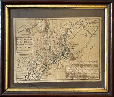
HERMAN MOLL (ENGLISH, C. 1654-1732) MAP OF NORTH AND SOUTH CAROLINA
Herman Moll Sale History
View Price Results for Herman MollRelated Maps & Atlases
More Items in Maps & Atlases
View MoreRecommended Transportation & Travel Collectibles
View More


Item Details
Description
HERMAN MOLL (ENGLISH, C. 1654-1732) MAP OF NORTH AND SOUTH CAROLINA, hand-colored engraving on laid paper, titled "CAROLINA / By / H. Moll Geographer" in a rectangular cartouche along lower right corner, depicting part of North Carolina and South Carolina with a small part of Virginia to the north and part of Florida to the south. Housed under glass in a modern gilt frame. Circa 1746. 11 3/8" x 8 1/2" sight, 12 1/2" x 9 1/2" OA.
Condition
Very good visual condition with some light fading to watercolor, a short tear in the center upper edge which goes 1/4" into image, an area of markings/stains in upper right corner, frame with minor wear, a few flakes/chips along edges. Not examined out of frame.
Buyer's Premium
- 25%
HERMAN MOLL (ENGLISH, C. 1654-1732) MAP OF NORTH AND SOUTH CAROLINA
Estimate $100 - $200
25 bidders are watching this item.
Shipping & Pickup Options
Item located in Mt. Crawford, VA, usOffers In-House Shipping
Local Pickup Available
Payment
Accepts seamless payments through LiveAuctioneers

Related Searches
TOP


![Emanuel Bowen Map North & South Carolina, Georgia: [Emanuel Bowen Map of North & South Carolina and Georgia] , "A New & Accurate Map of the Provinces of North & South Carolina Georgia & c. Drawn from late Surveys and regulated by Astron Observat. By E](https://p1.liveauctioneers.com/268/293228/155705053_1_x.jpg?height=310&quality=70&version=1687296979)


![1894 Cowles Civil War Map of South Carolina and Parts: Title/Content of Map: 1894 Cowles Civil War Map of South Carolina and Parts of North Carolina -- General Topographical Map, Sheet IV [Plate CXXXIX] Date: 1894, Washington Cartographer: C Cowles (compi](https://p1.liveauctioneers.com/5584/162222/81927562_1_x.jpg?height=310&quality=70&version=1582719732)


![Turky [Turkey] in Europe by Herman Moll. Balkans Greece Black Sea 1709 old map: CAPTION PRINTED BELOW PICTURE: 'Turky in Europe' DATE PRINTED: 1709 IMAGE SIZE: Approx 29.5 x 19.5cm, 11.5 x 7.75 inches (Medium) TYPE: Antique copperplate map CONDITION: Good; suitable for framing. P](https://p1.liveauctioneers.com/5584/328641/177014336_1_x.jpg?height=310&quality=70&version=1715113718)


![Il Regno d'Ungaria, Transilvania… Bosnia, Croatia… DE ROSSI / SANSON 1683 map: TITLE/CONTENT OF MAP: Il Regno d'Ungaria, Transilvania, Schiavonia, Bosnia, Croatia, Dalmatia [The Kingdoms of Hungary, Transylvania, Slavonia, Bosnia, Croatia, Dalmatia] Part of central and south-eas](https://p1.liveauctioneers.com/5584/328641/177014161_1_x.jpg?height=310&quality=70&version=1715113718)


![[Maps] Gio. Ant. Magnini, Italia, 1620: [Maps] Gio. Ant. Magnini, Italia, 1620, Giovanni Antonio Magnini. Italia, data in luce da Fabio suo figliuolo al Serenissimo Ferdinado Gonzaga Duca di Matoua edi Monserrato etc. Bologna, for Sebastian](https://p1.liveauctioneers.com/188/326797/176317457_1_x.jpg?height=310&quality=70&version=1713847031)
![[Maps] Martin Zeiler, Itinerarium Italiae, 1640: [Maps] Martin Zeiler, Itinerarium Italiae, 1640, Martini Zeilleri. Itinerarium Italiae Nov-Antiquae: oder, Raiss-Beschreibung durch Italien, Matthaus Merian, Frankfurt, 40 plates, most double-page, in](https://p1.liveauctioneers.com/188/326797/176317459_1_x.jpg?height=310&quality=70&version=1713847031)


