Tiddeman Map of the Entrance to the Chesapeake Bay
Similar Sale History
View More Items in Maps & AtlasesRelated Maps & Atlases
More Items in Maps & Atlases
View MoreRecommended Transportation & Travel Collectibles
View More


Item Details
Description
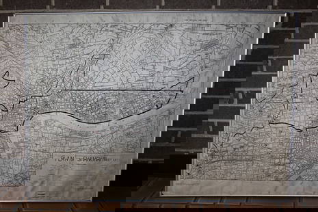
TIDDEMAN, Mark (fl. circa 1724-1760).
A Draught of Virginia from the Capes to York in York River and to Kuiquotan or Hamton in James River.
Engraved map.
London: Mount & Page, c. 1770.
18 1/4” x 23 3/4” sheet, 23 3/4” x 29” framed.
Notes: This copy of the map was published in William C. Wooldridge, Mapping Virginia, figure 94, pp. 97-98. Published in the English Pilot, the first English sea atlas devoted to charts of America, this map of the entrance to the Chesapeake Bay provided soundings for ship captains, and was the first printed map to include “Williamsburg.”
Buyer's Premium
- 25%
Tiddeman Map of the Entrance to the Chesapeake Bay
Estimate $1,200 - $2,500
3 bidders are watching this item.
Shipping & Pickup Options
Item located in New York, NY, usOffers In-House Shipping
Local Pickup Available
Payment
Accepts seamless payments through LiveAuctioneers

Related Searches
TOP


![Mitchell Map of the British and French Dominions of North America, 1755 - VERY RARE FIRST EDITION,: MITCHELL, John (1711-1768). A Map of the British and French Dominions of North America. Engraved map in 8 sheets. Published [London:] Publish'd by the Author Feb.ry 13th. 1755, and Sold by And: Miller](https://p1.liveauctioneers.com/1968/282833/149849101_1_x.jpg?height=310&quality=70&version=1680275215)

![Bernard / Miller Manuscript Map of the Great Eastern: [Map - Colonial New England] [BERNARD, Sir Francis, Governor of Colonial Massachusetts (1712-1779) & Francis MILLER, Surveyor (1733-1800). Untitled Manuscript Road Map of "The Great Eastern Road." [Ro](https://p1.liveauctioneers.com/1968/225974/116712071_1_x.jpg?height=310&quality=70&version=1636655147)


![Des Barres Map of Canada, St. Lawrence River & Gulf: DES BARRES, Joseph Frederick Wallet (1729 -1824). [Canada, St. Lawrence River & Gulf]. Engraved map with original hand color in outline. London, 1781. 30" x 63" sheet. Nice example of Des Barres' char](https://p1.liveauctioneers.com/1968/322135/173185704_1_x.jpg?height=310&quality=70&version=1709997984)


![Carte du Golphe de Bengale'. Bay of Bengal. India Burma Ceylon. BELLIN 1746 map: CAPTION PRINTED BELOW PICTURE: Carte du Golphe de Bengale tiré de la Carte de l'Océan Oriental, Publiée par Ordre de Mgr le Comte De Maurepas [Map of the Bay of Bengal] DATE PRINTED: 17](https://p1.liveauctioneers.com/5584/329387/177649439_1_x.jpg?height=310&quality=70&version=1715717898)


![Chinese Japanese Korean Ports sea chart. lighthouses mail routes. LARGE 1927 map: TITLE/CONTENT OF MAP: Chinese and Japanese Ports [inset Port Arthur & Dalny; Approaches to Shanghai; Wei-hai-wei; Kiao-chow; Kobe; Tokyo Bay; Yokohama] DATE PRINTED: 1927 IMAGE SIZE: Approx 50.5 x 70.](https://p1.liveauctioneers.com/5584/329387/177649259_1_x.jpg?height=310&quality=70&version=1715717898)


![1575 Braun and Hogenberg Views of Southern Spain's Vegel and Velis Malaga -- Vegel [on sheet with]: Title: 1575 Braun and Hogenberg Views of Southern Spain's Vegel and Velis Malaga -- Vegel [on sheet with] Velis Malaga Cartographer: Braun and Hogenberg Year / Place: 1575, Augsberg Map Dimension (in.](https://p1.liveauctioneers.com/5584/330117/177981860_1_x.jpg?height=310&quality=70&version=1716324705)


![[MAP]. TODESCHI, Pietro. [Nova et Acurata Totius Americae Tabula auct. G.I. Blaeu] America quarta: [MAP]. TODESCHI, Pietro. [Nova et Acurata Totius Americae Tabula auct. G.I. Blaeu] America quarta pars orbis quam plerunq, nuvum orbem appellitant primo detecta est anno 1492 a Christophoro Columbo...](https://p1.liveauctioneers.com/197/329395/177650542_1_x.jpg?height=310&quality=70&version=1715364962)


![[MAPS]. HOMANN, Johann Baptist, HOMANN HEIRS, and Georg Matthäus SEUTTER. [Composite Atlas].: [MAPS]. HOMANN, Johann Baptist (1663-1724), HOMANN HEIRS, and Georg Matthäus SEUTTER (1678-1757). [Composite Atlas]. [Nuremberg, Augsburg, and others: Homann Heirs and others, maps dated between](https://p1.liveauctioneers.com/197/329395/177650530_1_x.jpg?height=310&quality=70&version=1715364962)

![[MAP]. ORTELIUS, Abraham. Turcici Imperii Descriptio.1592.: [MAP]. ORTELIUS, Abraham (1527-1598). Turcici Imperii Descriptio. Antwerp, 1592. Engraved map with hand-coloring. Matted, framed, and double glazed, sight 406 x 521 mm (unexamined out of frame). Decor](https://p1.liveauctioneers.com/197/329395/177650538_1_x.jpg?height=310&quality=70&version=1715364962)


