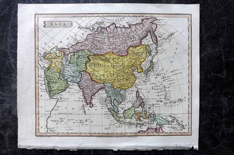
ANTIQUE 18TH C HAND COLORED MAP OF OTTOMAN EMPIRE
Similar Sale History
View More Items in Maps & Atlases
Related Maps & Atlases
More Items in Maps & Atlases
View MoreRecommended Transportation & Travel Collectibles
View More


Item Details
Description
An antique early 18th-century hand-colored engraved map representing the Ottoman Empire. Published in Nuremberg, Germany, 1720. Titled Imperium Turcicum, technical information in Latin in the lower left The map extends from the Persian Gulf and Red Sea to the Mediterranean and Caspian Seas and is centered on Cyprus. Fine detail work. Beige map, wooden frame. Antiquarian Collectibles, Engravings And Wall Prints, World Maps.
Dimensions: Overall size: Frame 26 1/2 x 29 3/4 in. Image 19 1/4 x 22 3/4 in. All measurements are approximate.
Condition
Overall good vintage condition. Signs of age and wear. Refer to photos. Sold As Is.
Buyer's Premium
- 28%
ANTIQUE 18TH C HAND COLORED MAP OF OTTOMAN EMPIRE
Estimate $100 - $150
23 bidders are watching this item.
Shipping & Pickup Options
Item located in Brooklyn, NY, usOffers In-House Shipping
Local Pickup Available
Payment

Related Searches
TOP


![Antique French Copper Engraved Colored Map, Amsterdam: 18th century antique French copper engraved and hand colored maps of Amsterdam, Netherlands titled "Lemouicum, Auctore Jo. Faiano M.L. - Lymosin [on sheet with] Topographia Limaniae, Auctore Gabriele](https://p1.liveauctioneers.com/6377/128239/65869733_1_x.jpg?height=310&quality=70&version=1540604375)


![[Maps] Martin Zeiler, Itinerarium Italiae, 1640: [Maps] Martin Zeiler, Itinerarium Italiae, 1640, Martini Zeilleri. Itinerarium Italiae Nov-Antiquae: oder, Raiss-Beschreibung durch Italien, Matthaus Merian, Frankfurt, 40 plates, most double-page, in](https://p1.liveauctioneers.com/188/326797/176317459_1_x.jpg?height=310&quality=70&version=1713847031)


