


MAP, Hudson Bay, Canada, Bellin
Similar Sale History
View More Items in Maps & Atlases


![[MAP] BELLIN. CARTE DE LA BAYE DE HUDSON. 1757: M.B. Ingr. de la Marine [Bellin, Jacques Nicolas]. CARTE DE LA BAYE DE HUDSON. Pour Servir a l'Histoire Generale des Voyages. (Paris) 1757. Engraved map with decorative cartouche, shrinkwrapped in mat](https://p1.liveauctioneers.com/8124/322212/173235047_1_x.jpg?height=310&quality=70&version=1709937662)


Related Maps & Atlases
![Carte du Golphe de Bengale'. Bay of Bengal. India Burma Ceylon. BELLIN 1746 map: CAPTION PRINTED BELOW PICTURE: Carte du Golphe de Bengale tiré de la Carte de l'Océan Oriental, Publiée par Ordre de Mgr le Comte De Maurepas [Map of the Bay of Bengal] DATE PRINTED: 17](https://p1.liveauctioneers.com/5584/329387/177649439_1_x.jpg?height=310&quality=70&version=1715717898)


![d'Anville (Jean Baptiste Bourguignon) [Untitled Composite Atlas with 102 map sheets], [probably: d'Anville (Jean Baptiste Bourguignon) [Untitled Composite Atlas with 102 map sheets], comprising 20 double-page maps, 9 two-sheet double-page maps, 3 two-sheet maps on folding double-pages [Asia, Afri](https://p1.liveauctioneers.com/5458/329231/177514974_1_x.jpg?height=310&quality=70&version=1715269091)

More Items in Maps & Atlases
View More


![[MAP]. TODESCHI, Pietro. [Nova et Acurata Totius Americae Tabula auct. G.I. Blaeu] America quarta: [MAP]. TODESCHI, Pietro. [Nova et Acurata Totius Americae Tabula auct. G.I. Blaeu] America quarta pars orbis quam plerunq, nuvum orbem appellitant primo detecta est anno 1492 a Christophoro Columbo...](https://p1.liveauctioneers.com/197/329395/177650542_1_x.jpg?height=310&quality=70&version=1715364962)


![[MAPS]. HOMANN, Johann Baptist, HOMANN HEIRS, and Georg Matthäus SEUTTER. [Composite Atlas].: [MAPS]. HOMANN, Johann Baptist (1663-1724), HOMANN HEIRS, and Georg Matthäus SEUTTER (1678-1757). [Composite Atlas]. [Nuremberg, Augsburg, and others: Homann Heirs and others, maps dated between](https://p1.liveauctioneers.com/197/329395/177650530_1_x.jpg?height=310&quality=70&version=1715364962)


Recommended Transportation & Travel Collectibles
View More


Item Details
Description
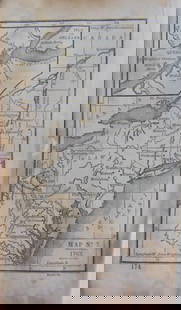
Hudson Bay, Canada. Jacques Nicolas Bellin, Karte von den Nord-Westlighen Theilen von America nach Middletons und Ellis Reisen im t 1742 und 1746..., from Allgemeine Historie der Reisen zu Wasser und Land…, 1753 (dated). Hand Color. Very nicely engraved chart that covers most of Hudson Bay. It locates Fort Prince of Wales and Fort York, the Ottawa Islands (here the Bakers Dozen), the track of Henry Ellis in 1746, Repulse Bay, Buttons Bay, and more. Middleton explored Wager Inlet, Repulse Bay, and the northern part of Roes Welcome in search of a Northwest Passage via Hudson Bay in 1746. The map includes a large and decorative title cartouche at top left. From a German edition published in 1758 by Johann Joachim Schwabe.
LITERATURE: Kershaw #457.
LITERATURE: Kershaw #457.
Condition
A crisp impression on watermarked paper, issued folding with minor toning. Grade: A
Dimensions
8.1 x 10.6 in
Buyer's Premium
- 20% up to $5,000.00
- 15% above $5,000.00
MAP, Hudson Bay, Canada, Bellin
Estimate $140 - $170
3 bidders are watching this item.
Get approved to bid.
Shipping & Pickup Options
Item located in Richmond, VA, usOffers In-House Shipping
Local Pickup Available
Payment
Accepts seamless payments through LiveAuctioneers

TOP