


Nice example of ext. scarce map of North Carolina (1814)
Similar Sale History
View More Items in Maps & Atlases


Related Maps & Atlases


![1890s Cram Map of Vermont [verso] New Hampshire -- Vermont [verso] New Hampshire: Title: 1890s Cram Map of Vermont [verso] New Hampshire -- Vermont [verso] New Hampshire Cartographer: G Cram Year / Place: 1890 c., Chicago Map Dimension (in.): 12.9 X 9.8 in. This is a very nice map](https://p1.liveauctioneers.com/5584/328338/176911596_1_x.jpg?height=310&quality=70&version=1715113718)


More Items in Maps & Atlases
View More


![[Maps] Gio. Ant. Magnini, Italia, 1620: [Maps] Gio. Ant. Magnini, Italia, 1620, Giovanni Antonio Magnini. Italia, data in luce da Fabio suo figliuolo al Serenissimo Ferdinado Gonzaga Duca di Matoua edi Monserrato etc. Bologna, for Sebastian](https://p1.liveauctioneers.com/188/326797/176317457_1_x.jpg?height=310&quality=70&version=1713847031)
![[Maps] Martin Zeiler, Itinerarium Italiae, 1640: [Maps] Martin Zeiler, Itinerarium Italiae, 1640, Martini Zeilleri. Itinerarium Italiae Nov-Antiquae: oder, Raiss-Beschreibung durch Italien, Matthaus Merian, Frankfurt, 40 plates, most double-page, in](https://p1.liveauctioneers.com/188/326797/176317459_1_x.jpg?height=310&quality=70&version=1713847031)


Recommended Transportation & Travel Collectibles
View More


Item Details
Description
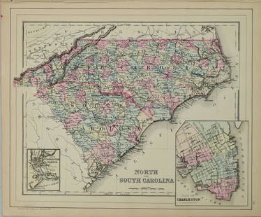
Extremely scarce map of Samuel Lewis map of North Carolina, appearing in the extremely scarce 1816 edition of Carey’s General Atlas (same map as in the 1814 Carey atlas). Early nineteenth century map of the state with great detail and good representation of the Outer Banks. Excellent representation of swamp lands. At bottom left is an inset entitled "Western Part of North Carolina on the same scale" containing Buncombe and Haywood counties. Haywood and Columbus counties, which were established in 1808, were the newest counties at the time the map was published. Interestingly, Anson County is delineated, but not named, despite the fact it was established in 1750. Towns, roads, rivers, mountains and swamps are well depicted throughout, with the exception of Haywood County, which is noted as "not surveyed." Nice, strong ink impresson. 11 x 18.5
Reserve: $450.00
Shipping:Domestic: Flat-rate of $6.00 to anywhere within the contiguous U.S. International: Foreign shipping rates are determined by destination. International shipping may be subject to VAT. Combined shipping: Please ask about combined shipping for multiple lots before bidding. Location: This item ships from Ohio
Your purchase is protected:
Photos, descriptions, and estimates were prepared with the utmost care by a fully certified expert and appraiser. All items in this sale are guaranteed authentic.
In the rare event that the item did not conform to the lot description in the sale, Jasper52 specialists are here to help. Buyers may return the item for a full refund provided you notify Jasper52 within 5 days of receiving the item.
Reserve: $450.00
Shipping:
Your purchase is protected:
Photos, descriptions, and estimates were prepared with the utmost care by a fully certified expert and appraiser. All items in this sale are guaranteed authentic.
In the rare event that the item did not conform to the lot description in the sale, Jasper52 specialists are here to help. Buyers may return the item for a full refund provided you notify Jasper52 within 5 days of receiving the item.
Condition
Very good plus
Buyer's Premium
- 15%
Nice example of ext. scarce map of North Carolina (1814)
Estimate $550 - $650
3 bidders are watching this item.
Shipping & Pickup Options
Item located in Ohio, US$6 shipping in the US
Payment
Accepts seamless payments through LiveAuctioneers
See More Items From This Jasper52 Seller

TOP