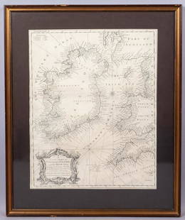
Pieter Goos (1616-1675) - Antique Map of Celtic Sea - Antique Sea Chart
Similar Sale History
View More Items in Maps & Atlases


Related Maps & Atlases
More Items in Maps & Atlases
View MoreRecommended Transportation & Travel Collectibles
View More


Item Details
Description
Pieter Goos (1616–1675). Accurate nautical chart of the Celtic Sea oriented north to the left. The title cartouche depicts Nereus and his children, the Nereids, with cross staffs and an astrolabe, all important instruments of navigation. Marking the southern coasts of Ireland and Wales, Cornwall, Brittany and the northern coast of Spain to Cape Finisterre, its purpose is to show the approaches to the English Channel, an important waterway for the Dutch East India Company. The route was infamous because determining latitude at sea was difficult: indeed, it was when the British fleet ran aground on the Isles of Scilly in 1707 that the famous Longitude Award was initiated. Amsterdam, circa 1666. Size: 18” x 23” inches / 46 cm x 58 cm
Condition
VG+++
Buyer's Premium
- 24%
Pieter Goos (1616-1675) - Antique Map of Celtic Sea - Antique Sea Chart
Estimate $2,000 - $2,400
2 bidders are watching this item.
Shipping & Pickup Options
Item located in Vasterhaninge, Stockholm, seSee Policy for Shipping
Payment

TOP


![Mount & Page: Antique Coast Profile of Ireland, 1749: Title/Content of Map: '[A description of the sea coast of Ireland]' The following places are shown or referred to on the coastal profile chart: Galloway (Galway) Aran Islands Limerick Date Printed: 17](https://p1.liveauctioneers.com/5584/110608/56777156_1_x.jpg?height=310&quality=70&version=1507840413)


![[Maps] Martin Zeiler, Itinerarium Italiae, 1640: [Maps] Martin Zeiler, Itinerarium Italiae, 1640, Martini Zeilleri. Itinerarium Italiae Nov-Antiquae: oder, Raiss-Beschreibung durch Italien, Matthaus Merian, Frankfurt, 40 plates, most double-page, in](https://p1.liveauctioneers.com/188/326797/176317459_1_x.jpg?height=310&quality=70&version=1713847031)


