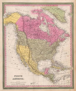
1813 Geographical map of N. and S. America by A. LeSage (Las Casas)
Similar Sale History
View More Items in Maps & AtlasesRelated Maps & Atlases
More Items in Maps & Atlases
View MoreRecommended Transportation & Travel Collectibles
View More


Item Details
Description
Large format, double-page hand-colored map of the geographical and political divisions in the Americas in 1813. An uncommon map. Shows young United States reaching only about halfway across the country. In this map Lake Erie is shown to be larger than Lake Superior. The entire northwestern half of the North American continent is labeled “Parts Unknown.” Shows Columbus’ route to the New World and traces Pizarro’s campaign of 1531. Note at upper northwest coast: “The whole of this coast, till now incorrect and little known, has been lately carefully ascertained by Vancouver.” This reference is to George Vancouver, the British naval officer whose voyages on The Discovery changed the knowledge of the upper western coast of North America. Tables at left show Geographical and Political Divisions of America, Productions, Discoveries, Establishments, etc., and lists (1) Unknown Parts; (2) English Possessions; (3) The American Union; (4) Spanish Possessions; (5) Portuguese Possessions; and (6) Countries hardly visited. A fascinating and extremely informative map of the American continents at a time when American discovery to the West was still fraught with mystery and danger. The map is from LeSage’s Historical, Genealogical, Chronological & Geographical Atlas, published by LeSage (Las Casas Emmanuel Comte de) in 1813. Numerous small spots of foxing, but a sound map. 14.5 x 15.75 map image on 18.25 x 26.5 sheet.
Reserve: $215.00
Shipping:Domestic: Flat-rate of $8.00 to anywhere within the contiguous U.S. International: Foreign shipping rates are determined by destination. Combined Shipping: Please ask about combined shipping for multiple lots before bidding. Location: This item ships from Ohio.
Your purchase is protected:
Photos, descriptions, and estimates were prepared with the utmost care by a fully certified expert and appraiser. All items in this sale are guaranteed authentic.
In the rare event that the item did not conform to the lot description in the sale, Jasper52 specialists are here to help. Buyers may return the item for a full refund provided when you notify Jasper52 within 5 days of receiving the item.
Reserve: $215.00
Shipping:
Your purchase is protected:
Photos, descriptions, and estimates were prepared with the utmost care by a fully certified expert and appraiser. All items in this sale are guaranteed authentic.
In the rare event that the item did not conform to the lot description in the sale, Jasper52 specialists are here to help. Buyers may return the item for a full refund provided when you notify Jasper52 within 5 days of receiving the item.
Condition
Very good
Buyer's Premium
- 15%
1813 Geographical map of N. and S. America by A. LeSage (Las Casas)
Estimate $250 - $285
1 bidder is watching this item.
Shipping & Pickup Options
Item located in Ohio, US$8 shipping in the US
Payment
Accepts seamless payments through LiveAuctioneers
See More Items From This Jasper52 Seller

TOP


![[Maps] Pair of Maps of N & S America: Pair of Maps: AN ACCURATE MAP OF NORTH AMERICA…BY EMANUEL BOWEN. 1747. Measuring from neatline to neatline 201 x 149mm. Vertical creases as folded, clean, Very Good. ***** AN ACCURATE MAP OF SOU](https://p1.liveauctioneers.com/3532/107013/54846861_1_x.jpg?height=310&quality=70&version=1501119763)


![[PICTORIAL MAPS – TRAVEL]. Three Pictorial Maps. 1940s/50s....: [PICTORIAL MAPS – TRAVEL]. Three Pictorial Maps. 1940s/50s. Three brochure sized foldout maps designed for travel including: Highroads to Happiness. Mexico City: Pemex Travel Club, ca. 1940s. &#](https://p1.liveauctioneers.com/928/325952/175495561_1_x.jpg?height=310&quality=70&version=1712935174)


![[Maps] Gio. Ant. Magnini, Italia, 1620: [Maps] Gio. Ant. Magnini, Italia, 1620, Giovanni Antonio Magnini. Italia, data in luce da Fabio suo figliuolo al Serenissimo Ferdinado Gonzaga Duca di Matoua edi Monserrato etc. Bologna, for Sebastian](https://p1.liveauctioneers.com/188/326797/176317457_1_x.jpg?height=310&quality=70&version=1713847031)


