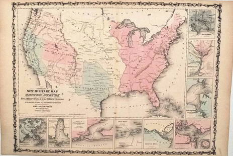
1863 Phelps and Watson US Map with Civil War Battles -- Phelps & Watson's Historical and Military
Similar Sale History
View More Items in Maps & AtlasesRelated Maps & Atlases
More Items in Maps & Atlases
View MoreRecommended Transportation & Travel Collectibles
View More


Item Details
Description
Reserve: $360.00
Shipping:
Your purchase is protected:
Photos, descriptions, and estimates were prepared with the utmost care by a fully certified expert and appraiser. All items in this sale are guaranteed authentic.
In the rare event that the item did not conform to the lot description in the sale, Jasper52 specialists are here to help. Buyers may return the item for a full refund provided you notify Jasper52 within 5 days of receiving the item.
Condition
Fair-Good. Multiple issued fold splits, most closed on verso. A few fold corner voids. Some staining. Voids in neat line area. Narrow margins. Nice hand-color.
Buyer's Premium
- 15%
1863 Phelps and Watson US Map with Civil War Battles -- Phelps & Watson's Historical and Military
Estimate $500 - $600
4 bidders are watching this item.
Shipping & Pickup Options
Item located in Ohio, US$22 shipping in the US
Payment
Accepts seamless payments through LiveAuctioneers
See More Items From This Jasper52 Seller

Auction Curated By

Maps Expert
TOP


![1893 Civil War Map of the Battles of Bull Run and Manassas -- Plan of the Battle Field at Bull Run: Title: 1893 Civil War Map of the Battles of Bull Run and Manassas -- Plan of the Battle Field at Bull Run [with] Map of the Battle-Fields of Manassas… [Plate III] Cartographer: US War Department](https://p1.liveauctioneers.com/5584/307299/164242651_1_x.jpg?height=310&quality=70&version=1698786194)

![1893 Civil War Map of Washington and NE. Virginia -- Surveys for Military Defenses Map of: Title: 1893 Civil War Map of Washington and NE. Virginia -- Surveys for Military Defenses Map of Northeastern Virginia and Vicinity of Washington [Sheet 1 Plate VII] Cartographer: US War Department Ye](https://p1.liveauctioneers.com/5584/241996/125442504_1_x.jpg?height=310&quality=70&version=1648585952)
![1893 Civil War Map of Northern Virginia -- Sheet 2. Survey for Military Defenses Map of Northeastern: Title: 1893 Civil War Map of Northern Virginia -- Sheet 2. Survey for Military Defenses Map of Northeastern Virginia and Vicinity of Washington [Plate VII] Cartographer: US War Department Year / Place](https://p1.liveauctioneers.com/5584/270923/141842311_1_x.jpg?height=310&quality=70&version=1670433092)


![Battle of Coronel, November 1st 1914. First World War. 1920 old antique map: CAPTION PRINTED BELOW PICTURE: Coronel November 1st 1914 [Battle of Coronel] DATE PRINTED: 1920 IMAGE SIZE: Approx 68.0 x 55.5cm, 26.75 x 21.75 inches (Large); Please note that this is a folding map.](https://p1.liveauctioneers.com/5584/326888/175994716_1_x.jpg?height=310&quality=70&version=1713903186)


![The finest and largest map of Long Island of the period: [MAP-NEW YORK] MATHER, W.W. Geological Map of Long & Staten Islands with the Environs of New York. [New York: 1842]. Hand-colored lithographed map on two sheets joined from the topographical surve](https://p1.liveauctioneers.com/292/326828/175962867_1_x.jpg?height=310&quality=70&version=1713473479)


