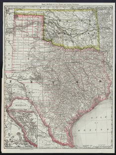
(RAILROADS.) Rand, McNally & Co. A Correct Map of the
Similar Sale History
View More Items in Maps & AtlasesRelated Maps & Atlases
More Items in Maps & Atlases
View MoreRecommended Transportation & Travel Collectibles
View More


Item Details
Description
(RAILROADS.) Rand, McNally & Co. A Correct Map of the United States of America, Showing the Atchison, Topeka and Santa Fe R.R. and Connections. Color-printed lithographed railroad map. 15½x27½ inches overall, folding, promotional pamphlet on verso; minor wear at fold intersections. Chicago, circa 1882
Showing rail connections from Kansas City to Denver and mining towns in Colorado, on through New Mexico and Arizona to California and northern Mexico. Pamphlet verso contains agent information, schedules, connections and regulations, a large pictorial advertisement for Las Vegas Hot Springs, New Mexico, and another pictorial promoting the "Event of the Year... the National Mining and Industrial Exposition at Denver, August 1st to September 30th, 1882". Modelski 63 (citing a slightly different 1888 edition).
Showing rail connections from Kansas City to Denver and mining towns in Colorado, on through New Mexico and Arizona to California and northern Mexico. Pamphlet verso contains agent information, schedules, connections and regulations, a large pictorial advertisement for Las Vegas Hot Springs, New Mexico, and another pictorial promoting the "Event of the Year... the National Mining and Industrial Exposition at Denver, August 1st to September 30th, 1882". Modelski 63 (citing a slightly different 1888 edition).
Buyer's Premium
- 30%
(RAILROADS.) Rand, McNally & Co. A Correct Map of the
Estimate $300 - $400
5 bidders are watching this item.
Shipping & Pickup Options
Item located in New York, NY, usOffers In-House Shipping
Local Pickup Available
Payment

Auction Curated By

Specialist, Maps & Atlases
Related Searches
TOP


![Map of Colorado: Publication Date: 1883 Title: Map of Colorado Cartographer: [RAND, MCNALLY & CO.] Publisher: H.H. HARDESTY Height: 13.1 Width: 19.4 230, 231. Very detailed view of the competing railroads. Still shows](https://p1.liveauctioneers.com/5584/206214/104719873_1_x.jpg?height=310&quality=70&version=1623189807)


![1898 Rand McNally Map of Texas [verso] Indian Territory and Oklahoma -- Texas [verso] Oklahoma and: Title: 1898 Rand McNally Map of Texas [verso] Indian Territory and Oklahoma -- Texas [verso] Oklahoma and Indian Territory Cartographer: Rand McNally Year / Place: 1898, Chicago Map Dimension (in.): 9](https://p1.liveauctioneers.com/5584/328338/176911581_1_x.jpg?height=310&quality=70&version=1715113718)
![1914 Rand McNally Map of Austria-Hungary [verso] German Empire -- Austria-Hungary [verso] German: Title: 1914 Rand McNally Map of Austria-Hungary [verso] German Empire -- Austria-Hungary [verso] German Empire Cartographer: Rand McNally Year / Place: 1914, Chicago Map Dimension (in.): 9.2 X 13 in.](https://p1.liveauctioneers.com/5584/328338/176911532_1_x.jpg?height=310&quality=70&version=1715113718)
![1888 Rand McNally Map of Louisiana -- [Louisiana]: Title: 1888 Rand McNally Map of Louisiana -- [Louisiana] Cartographer: Rand McNally Year / Place: 1888, Chicaho Map Dimension (in.): 12.7 X 19.1 in. This is an excellent, large map of Louisiana. Plent](https://p1.liveauctioneers.com/5584/328338/176911517_1_x.jpg?height=310&quality=70&version=1715113718)


![[Maps] Gio. Ant. Magnini, Italia, 1620: [Maps] Gio. Ant. Magnini, Italia, 1620, Giovanni Antonio Magnini. Italia, data in luce da Fabio suo figliuolo al Serenissimo Ferdinado Gonzaga Duca di Matoua edi Monserrato etc. Bologna, for Sebastian](https://p1.liveauctioneers.com/188/326797/176317457_1_x.jpg?height=310&quality=70&version=1713847031)
![[Maps] Martin Zeiler, Itinerarium Italiae, 1640: [Maps] Martin Zeiler, Itinerarium Italiae, 1640, Martini Zeilleri. Itinerarium Italiae Nov-Antiquae: oder, Raiss-Beschreibung durch Italien, Matthaus Merian, Frankfurt, 40 plates, most double-page, in](https://p1.liveauctioneers.com/188/326797/176317459_1_x.jpg?height=310&quality=70&version=1713847031)


