


 Discovery- InteriorsBonhamsSponsored.Your ad here?
Discovery- Interiors
Bonhams
Sponsored.Your ad here?


Discovery- InteriorsBonhamsSponsored.Your ad here?
Discovery- Interiors
Bonhams
Sponsored.Your ad here?

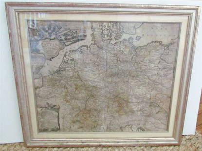
Antique Framed Map of Columbia County, NY 1829
Similar Sale History
View More Items in Books


Related Books


More Items in Books
View More


Recommended Books, Magazines & Papers
View More


Item Details
Description
Antique Framed Map of Columbia County, NY, dated 1829. Engraved by Rawdon Clark & Co, Albany, NY. Also marked Rawdon Wright, New York. Map includes locations of mills, churches and stage roads. Nicely framed behind glass in dark wood, wired and ready to hang.
Dimensions are 24 in h x 20.5 in w x 1 in d. Condition is fair with discoloration and a crease along the side. Please call or email for a detailed condition report.
Condition
See description and photos for condition. Please email or call for a more detailed condition report. We grade on a scale from excellent, very good, good, fair, to poor; that said, all lots are sold in as is condition at time of sale, and condition listings are given as a courtesy for guidance only and should be evaluated by personal inspection by the bidder.
Dimensions
24 x 20.5 x 1 in
Buyer's Premium
- 20%
Antique Framed Map of Columbia County, NY 1829
Estimate $50 - $100
8 bidders are watching this item.
Shipping & Pickup Options
Item located in Hudson, NY, usSee Policy for Shipping
Local Pickup Available
Payment
Accepts seamless payments through LiveAuctioneers

Related Searches
TOP