Sold2023Twelve Framed British MapsA set of twelve framed British maps, circa 1940-1950, designed and drawn by Ernest Clegg, each map is framed. Dimensions:Sight 17 x 22in; frame 18 1/2 x 23 1/2in.See Sold Price
Sold2017Group of twelve framed maps to include Africa,Group of twelve framed maps to include Africa, Johnson's Russia, Mississippi, Arkansas, Ohio, Missouri, Kentucky, Africa, Asia, Asia, Greece, and China. 11 1/4" x 13 1/2" to 14" x 16 3/4" Provenance:See Sold Price
Sold2021BRITISH CHANNEL & BAY OF BISCAY MAPWilliam Faden (1749-1836) Framed map of British Channel & Bay of Biscay. Measures 41" x 26.5" with frame.See Sold Price
Sold20211638 JAN JANSSON HAND COLORED ANTIQUE BRITISH ISLES MAPMAGNAE BRITANNIAE ET HIBERNIAE, NOVA DESCRIPTO Amsterdam, c. 1638 by Jan Jansson Framed under glass. Size (framed) 23 by 26.5" Not inspected out of frame. Map is separated at the middle fold. ProvenanSee Sold Price
Sold2021Map, "British Possessions in North America"From Pinkerton's Modern Atlas, ca. 1810, published by Dobson, Philadelphia 21" x 28 3/4" sight size, 25 1/2" x 36" framed.See Sold Price
Sold2019Framed Map of Southern & Northern British IndiaFramed Map of Southern & Northern British India. Professionally matted and framed map depicting southern and northern British India. Frame measures 28.5 inches x 59 inches.See Sold Price
Sold2023British School, Map of AfricaBritish, 1809 hand-colored map of Africa "including the last discoveries", 14 1/4" x 14 1/4" sight size, 15 1/4" x 15 1/4" framed.See Sold Price
Sold2024SAXTON'S MAP OF ESSEX ENGLAND 1576 MUSEUM EDITIONChristopher Saxton 1540-1610 Map of Essex 1576 England . British Museum Maps C.7 C.I. notation. Detailed and Colored. Exact print date unknown. 20.50" x 25" FramedSee Sold Price
Sold2023Two Antique Maps of Indian Territories British America Far WestTwo Antique Maps of Indian Territories British America Far West MEDIUM: Published Printing DIMENSIONS: Framed 18 x 27 inches DESCRIPTION: These early antique maps of British America show Districts, InSee Sold Price
Sold2022[MAPS]. –– [ENGLAND]. A group of three 18th century maps of...[MAPS]. –– [ENGLAND]. A group of three 18th century maps of English towns and territories. Original map engravings depicting Bath, Suffolk, and the Remote British Isles. Framed and matted.See Sold Price
Sold2023British School, Needlework "Map of the World"British, 1784, needlework depicting a map of the world with floral decorations at the corners, signed "Ann Smith" l.c., 16 1/2" x 29 3/4" sight size, 18 1/2" x 32" framed.See Sold Price
Sold2018Scotland Pictorial Map - The British & Holiday Asso.Description: Antique framed original Scotland pictorial map by the permission of the British & Holiday Association.Measurement approximate: 32 H x 20 W. Material: All Pure Linen Fabric. Shipping cost:See Sold Price
Sold2020ANTIQUE MAP FRANCE SUTTON NICHOLLSFine antique map of British Isles by Sutton Nicholls 18th/19th century. Measuring framed 22 x 26 inches wide sight view 15 x 20 inches. Good condition. Printed on laid paper.See Sold Price
Sold2018BRITISH SCHOOL (19TH CENTURY) MAPS OF NUBIA & ABYSSINIABRITISH SCHOOL (19TH CENTURY) MAPS OF NUBIA & ABYSSINIA and NORTHERN ITALY, 1828 and 1830 Handcolored engravings: 21 1/2 x 17 3/4 in. each (sight) Framed; published by Longman, Rose, Orme, Brown, GreeSee Sold Price
Sold201912 Copperplate Engravings Celestial ChartsCollection of Twelve (12) Circa 1776 British Celestial Charts. Each one is Copperplate Engraved, Hand Colored and Professionally Mounted. Maps Depicting the Horoscope Constellations in Color from an "See Sold Price
Sold2017Framed Artwork Robert Furber FruitsTwelve Months of Fruits framed artwork, October 1732, from the Collection of Rob Furber Gardiner at Kensington. Furber, a British horticulturist and author, wrote the book "12 Months of Fruit" which fSee Sold Price
Sold20182 Framed antique maps2 Framed antique maps, probably from an old atlas, British America & The United States, map drawn & engraved by J. Rapkin, illustrations by H. Warren & illustrations by R. Wallis, Maps are 10" x 13",See Sold Price
Sold2023ANTIQUE EAST INDIA ISLANDS C 1840 MAPAntique East India Color Lithograph Map c. 1840 by a British Mapmaker. Purchased at Wattis Fine Art, Hong Kong. Professionally framed and matted. In frame measures 23.25"x22.25"x1.25" Weight 7 pds. PRSee Sold Price
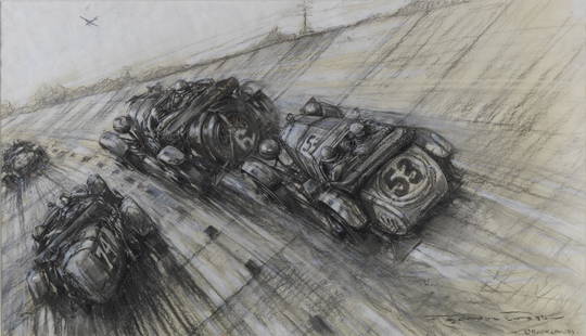
Sold2022Frederick Gordon Crosby (British, 1885-1943): 'Brooklands',Frederick Gordon Crosby (British, 1885-1943): 'Brooklands', signed, charcoal and wash mixed-media on paper, depicting the 1929 Junior Car Club Double Twelve at Brooklands, 39 x 68cm, mounted, framed aSee Sold Price
Sold20222 Framed 18th C. Faden Maps - Greece & Denmark**Originally Listed At $200** Cartographer: William Faden (British, 1749-1836). Engraver: William Palmer (British, 1735-1812). "Graecie Antiquae et Aegaei Maris Tabula" Published by William Faden JanuSee Sold Price
Sold2022Map of United States, JH Colton, ca 1849A framed map of the United States, Map of the United States of America, The British Provinces, Mexico, the West Indies and Central America with part of New Granada and Venezuela by JH Colton, ca 1849,See Sold Price
Sold2017NORTH AMERICA COLORED MAP, C. 1763, POSTLETHWAYTFramed antique map c. 1770, "North America, Plate 1" from the publication "Dictionary of Trade and Commerce" by Malachy Postlethwayt (British, 1707-1767), hand colored, also reading "North America, PeSee Sold Price
Sold2017NORTH AMERICA COLORED MAP, C. 1763, POSTLETHWAYTFramed antique map c. 1770, "North America, Plate III" and "Part of North America, Plate IV", from the publication "Dictionary of Trade and Commerce" by Malachy Postlethwayt (British, 1707-1767), handSee Sold Price
Sold2020Angliae Scotiae et Hiberniae 1572 MapThe British Isles by Abraham Ortelius. The hand tinted copperplate engraved map has been nicely framed and with a reverse painted glass perimeter. Some slight discoloration consistent with age. OveralSee Sold Price
Jun 18DOYLE Auctioneers & AppraisersSet of Twelve Satirical Anthropomorphic Maps of Europe$400(1 bid)


![[MAPS]. –– [ENGLAND]. A group of three 18th century maps of...: [MAPS]. –– [ENGLAND]. A group of three 18th century maps of English towns and territories. Original map engravings depicting Bath, Suffolk, and the Remote British Isles. Framed and matted.](https://p1.liveauctioneers.com/928/252933/131521915_1_x.jpg?height=310&quality=70&version=1656110480)