Sold2018Scotland Pictorial Map - The British & Holiday Asso.Description: Antique framed original Scotland pictorial map by the permission of the British & Holiday Association.Measurement approximate: 32 H x 20 W. Material: All Pure Linen Fabric. Shipping cost:See Sold Price
Sold2022BURLEY, David William (1901-1990). Map of Ireland. 1955. Lo...BURLEY, David William (1901-1990). Map of Ireland. 1955. London: Baynard Press. Colorful pictorial map poster produced by British Railways in cooperation with the Bord Failte Eireann (Irish Tourist BoSee Sold Price
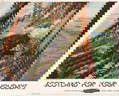
Sold2023TERENCE CUNEO (1907-1996). SCOTLAND FOR YOUR HOLIDAYS / BRITISH RAILWAYS. 1952. 40x50 inches, 101&#TERENCE CUNEO (1907-1996) SCOTLAND FOR YOUR HOLIDAYS / BRITISH RAILWAYS. 1952. 40x50 inches, 101½x127 cm. Waterlow, London. Condition A- / B+: minor repaired tears at edges; minor creases and abrSee Sold Price
Sold2020Bryce, James 1881 Lot of 3 Maps of the British IslesEngland & Wales, Scotland and Physical Map of the British Isles. Lithograph Maps Published 1881, London for ""The International Atlas and Geography..." by James Bryce. Maps by Edward Weller & John BarSee Sold Price
Sold2020Bryce, James 1881 Pair of Maps England/Wales & ScotlandEngland & Wales, Scotland and Physical Map of the British Isles. Lithograph Maps Published 1881, London for ""The International Atlas and Geography..." by James Bryce. Maps by Edward Weller & John BarSee Sold Price
Sold20181856 Pictorial Map of the Baltic Sea [verso] BritishTitle/Content of Map: 1856 Pictorial Map of the Baltic Sea [verso] British Royal Navy -- Picture Map of the Baltic Sea [verso] Royal Navy Review at Spithead Date Printed: 1856, London Cartographer: LoSee Sold Price
Sold2019Bryce, James 1881 Lot of 4 Maps of the UK, ScotlandIncl England/Wales, British Isles and Scotland. Lithograph Maps Published 1881, London for ""The International Atlas and Geography..." by James Bryce. Maps by Edward Weller & John Bartholomew. UncommoSee Sold Price
Sold2022Sabena Belgian World Airways / Holiday Abroad ExtraSabena Belgian World Airways / Holiday Abroad Extra City Plans. 1961-62. A pictorial map of Europe is covered in small illustrations of important buildings and cities, bordered by the 1961-62 calendarSee Sold Price
Sold2016E H Spencer Pictorial Map of Yorkshire, original posterE H Spencer Pictorial Map of Yorkshire, original poster printed for BR(NER) by British Colour Printing 1959 - 102 x 127 cm Property of the late Albert Cook ex Publicity Manager BR (NER)See Sold Price
Sold2023Gross, Alexander 1920 Lot of 11 Large Maps. British IslesIncl British Isles, Liverpool/Manchester, Birmingham, Newscastle, Hull and Leeds, England and Wales, Scotland and London. Large Lithograph Maps Published 1920, London for "The Daily Telegraph VictorySee Sold Price
Sold2021Bartholomew, John 1904 Lot of 4 Railway Maps UK IrelandRailways of Scotland, Ireland, England & Wales, and General Map of the British Isles with Railway & Steamship Routes. Lithograph Map Published 1904, London for "The Survey Gazetteer of the British IslSee Sold Price
Sold2021BRITISH MAP OF ENGLAND AND WALES NEEDLEWORK SAMPLERBRITISH MAP OF ENGLAND AND WALES NEEDLEWORK SAMPLER, silk on linen, oval vignette featuring the map of England and Wales with counties outlined and named, surrounding areas named including Scotland, ISee Sold Price
Sold2017British Isles: C England Wales Scotland Ireland MapBritish Isles: Counties. England Wales Scotland Ireland. Tallis/rapkin 1851 Map. Vignettes: London; Edinburgh; Dublin. Approx 36.5 x 26.5cm, 14.5 x 10.25 inches (Large). Antique engraved map by J RapkSee Sold Price
Sold2024Ptolemy & Magini, pub. 1620 - Map of the British Isles (England, Scotland, Ireland) / Verso: Map ofThis early map engraving is from Claudius Ptolemaeus (Ptolemy) and Giovanni Antonio Magini's Geografia cio? Descrittione Universale della Terra Partita in due volumni, Nel Primo de' quali si contengonSee Sold Price
Sold20171835 Bradford Map of British IslandsClean hand-colored 1835 map of the British Islands by the important American mapmaker T. G. Bradford. It includes England, Scotland, Wales and Ireland and covers from the southern tip of the ShetlandSee Sold Price
Sold20182 MAPS FRAMED, SCOTLAND OF OLD, IRELAND, BULLOCK MAPSTwo framed maps, Scotland of Old and Ireland. Windowbox style frames. 1969 Bullock Pictorial Historical Map of Ireland - This is a delightful 1969 L.G. Bullock pictorial historical map of Ireland. BulSee Sold Price
Sold2023Rapkin, John 1860 Lot of 3 British MapsIncl Channel Islands, England/Wales and Scotland. Steel Engraved Map Published 1860 by The London Printing & Published Company, London for "The Royal Dictionary-Cyclopedia for Universal Reference" bySee Sold Price
Sold2021Fullarton (Pub) 1856 Lot of 4 Antique British MapsIncl Ports and Harbours on the South East Coast of England, Ditto North West Scotland, Ditto South Coast England, and Plymouth Sound. Steel Engraved Map Published 1856-58, by A. Fullarton, London forSee Sold Price
Sold2022National Encyclopedia 1891 Lot of 5 British MapsIncl Scotland, England, Geology, Tides etc. Lithograph Maps Published 1891-1901 by William Mackenzie, London for "The National Encyclopedia: A dictionary of Universal Knowledge" Center fold as issued.See Sold Price
Sold2020Abraham Ortelius Map of Scotland Britain 1590Abraham Ortelius (1527-1598), "Brittanicarum Insularum Vetus Descriptio," Antwerp, 1590. Hand colored engraving map of the British Isles featuring Scotland and the United Kingdom. The map appeared inSee Sold Price
Sold2021King Henry's Map of the British IslesBL Cotton MS Augustus I i 9'. Illustrated Commentary volume. Pictorial hardcover with gilt title to spine. Slipcase with gilt initial vignette. Colour endpapers. Bookplate. Full-page and in-text colouSee Sold Price
Sold2022Leigh, Samuel 1826 Lot of 4 British County MapsCopper Engraved Map Published 1826, London for "Leigh's New Pocket Road-Book of England, Wales and Part of Scotland..." by Samuel Leigh. Maps Engraved by Sidney Hall. Paper Size: 5.5 x 3.5 inch (14 xSee Sold Price
Sold2022Leigh, Samuel 1826 Lot of 4 British County MapsCopper Engraved Map Published 1826, London for "Leigh's New Pocket Road-Book of England, Wales and Part of Scotland..." by Samuel Leigh. Maps Engraved by Sidney Hall. Paper Size: 5.5 x 3.5 inch (14 xSee Sold Price
Sold2022Leigh, Samuel 1826 Lot of 4 British County MapsCopper Engraved Map Published 1826, London for "Leigh's New Pocket Road-Book of England, Wales and Part of Scotland..." by Samuel Leigh. Maps Engraved by Sidney Hall. Paper Size: 5.5 x 3.5 inch (14 xSee Sold Price
Jun 02Schilb Antiquarian Rare Books1897 History of British Empire England Scotland Canada James II MAPS India 6v$2(2 bids)
1 day LeftPotter & Potter AuctionsPictorial Map of Hollywood and Vicinity / Hollywood Film Ca...$125(1 bid)
1 day LeftPotter & Potter AuctionsHANDY, R.D. (1879 – 1959). Paul Bunyan’s Pictorial Map of t...$200(1 bid)
1 day LeftPotter & Potter Auctions[NEW YORK CITY – PICTORIAL MAPS]. Group of 3 pictorial maps...$200(1 bid)
1 day LeftPotter & Potter AuctionsMEDINA, Miruel Gomez. Pictorial Map of Mexico. 1931. USA: F...$150(1 bid)
Featured21 hrs LeftJasper52Pictorial map of the Caucasus. Russia Georgia Azerbaijan Armenia INTOURIST c1932$850
1 day LeftPotter & Potter Auctions[PICTORIAL MAPS – TRAVEL]. Three Pictorial Maps. 1940s/50s....$150
1 day LeftPotter & Potter AuctionsSTORM, Mark. Official Texas Brags Map of North America. 194...$200(1 bid)
1 day LeftPotter & Potter AuctionsBOLLMANN, Hermann (1911 – 1971). Map of New York City. 1962.$100


![1856 Pictorial Map of the Baltic Sea [verso] British: Title/Content of Map: 1856 Pictorial Map of the Baltic Sea [verso] British Royal Navy -- Picture Map of the Baltic Sea [verso] Royal Navy Review at Spithead Date Printed: 1856, London Cartographer: Lo](https://p1.liveauctioneers.com/5584/119622/60966608_1_x.jpg?height=310&quality=70&version=1522802109)


![[NEW YORK CITY – PICTORIAL MAPS]. Group of 3 pictorial maps... (1 of 3)](https://p1.liveauctioneers.com/928/325952/175495562_1_x.jpg?height=282&quality=70&version=1712935174)


![[PICTORIAL MAPS – TRAVEL]. Three Pictorial Maps. 1940s/50s.... (1 of 4)](https://p1.liveauctioneers.com/928/325952/175495561_1_x.jpg?height=282&quality=70&version=1712935174)


