Sold2022Dudley Sea Chart of PortugalDUDLEY, Sir Robert (1574-1649). [Portugal] Carta Particolare Del Oceano Che Comincia Con il Capo S. Vincentio E Finisco Con Il Capo Roxo in PortogalloEngraved map. Florence, 1646. 20 7/8" x 17" sheet.See Sold Price
Sold2022Dudley Sea Chart of Western FranceDUDLEY, Sir Robert (1574-1649). [France] Carta particolare della costa di Guasconnia in Francia che comincia con il Fiuime di Burdeaux e Finisce con l'Isola di Heys. Engraved map. Florence, 1646. 20 7See Sold Price
Sold2020Il Canada, le Colonie Inglesi con la Luigiana, eTITLE/CONTENT OF MAP: 'Il Canada, le Colonie Inglesi con la Luigiana, e Florida di nuova projezione' "The British colonies in North America, with Louisiana and Florida". Much of the lands between theSee Sold Price
Sold2017Florimi Map of Jerusalem and Christ Crucifiction, 1595Map: 1595 Florimi Map of Jerusalem and Christ Crucifiction -- L'Antichissima citta di Gierusalemme come era nel tempo di N. S. Gisu Christo con le sur cechiaratione Cartographer: M. Florimi Year / PlaSee Sold Price
Sold2020[Maps & Atlases] Braun, Georg, and Frans Hogenberg,[Maps & Atlases] Braun, Georg, and Frans HogenbergGroup of 5 Sixteenth Century Views1. Amoenissimus castri Granatensis, vulgo Alhambre dicti, ab Oriente prospectus(Cologne, ca. 1598). Hand-colored engSee Sold Price
Sold20181740 Rupprech/Haffner Antique View of LondonTitle/Content of Map: 1740 Rupprech/Haffner View of London -- Lodinium [or] Prospectus Londinum, Sedes Regia, et praecipua Urbs in Anglia ad Temesium Fluvium . . . Date Printed: 1740 c. Augsburg CartoSee Sold Price
Sold2022Dudley Sea Chart of DenmarkDUDLEY, Sir Robert (1574-1649). [Denmark] Carta particolare che comincia con il gran fiume Albis e contene parte dell mare Baltico e Ientrata al sondo di Danemarca... Engraved map. Florence, 1646.20 7See Sold Price
Sold2022John Smith Map of New England, Extremely Rare 2nd StateSMITH, John (1580-1631). New England the most remarqueable parts thus named by the high and mighty Prince Charles, Prince of great Britaine. Observed and described by Captayn John Smith... CopperplateSee Sold Price
Sold2023Telegraph Patent Model by White & White, 1855Telegraph Patent Model by White & White, 1855 Telegraphic key apparatus, patented by Leroy S. White and Lewis White, USA, on May 22, 1855, with 28 keys, mother-of-pearl key tops, engraved characters,See Sold Price
2021GREAT NORTHERN’S 2 GREAT TRAINS SYSTEM MAP.Huge dramatic reverse glass advertising Great Northern's two great trains, Empire Builder and Western Star. In script just below Great Northern logo it states "Steamliners twice a day, each way, betweSee Sold Price
Sold2022[STREETER COPY] SEARCY, I. G. Map of Florida constructed principally from authentic documents in the[STREETER COPY] SEARCY, I. G. Map of Florida constructed principally from authentic documents in the Land office at Tallahassee by I. G. Percy. Published by I.G. Searcy Tallahassee & F. Lucas Jr., BalSee Sold Price
Sold2020Gastaldi Map of Africa*** START PRICE IS THE RESERVE *** [Africa]. GASTALDI, Giacomo (1500-1566) & FORLANI, Paolo (fl. 1560-1571). La Descrittione dell'Africa. Engraved Map. Venice: Paolo Forlani, 1562. 19 x 25 1/4 inchesSee Sold Price
Sold2016T-O World Map.- Lucanus (Marcus Annaeus) Pharsalia,Lucanus (Marcus Annaeus) Pharsalia, manuscript on paper, [Northern Italy (possibly Padua), first half of the fifteenth century]. 294 x 217mm., I + 149 + I leaves (including defective leaves and 3 blanSee Sold Price
Sold2024Petrus Plancius, Engraved World MapOrbis Terrarum Typus de Integro Multis in Locis Emendatus. Petrus Plancius (1552-1622). Copper-plate engraving with original hand color in full. Amsterdam, 1594. Some stains, creases, folds. Sight sizSee Sold Price
Sold2015A Fine & Rare Map of New York.Bernard Ratzer "Plan of the City of New York". Signed lower right in the plate "T. Kitchin Sculpt" (Kitchin recorded the cartographer's name as Ratzen (sic) rather than Ratzer). The map backed, rolledSee Sold Price
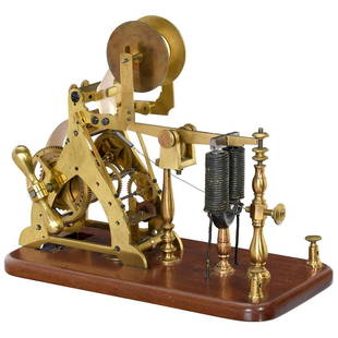
Sold2023Early Weight-Driven Morse Telegraph by Palmer & Hall, c. 1850Early Weight-Driven Morse Telegraph by Palmer & Hall, c. 1850 Marked "Palmer & Hall, Boston", polished brass, relief writer, on mahogany base, size 11 2/5 x 6 in., with string, working! - One of the eSee Sold Price
Sold20201761 MAP OF NORTH AMERICA BY ROCQUE18th century map GENERAL MAP OF NORTH AMERICA 1754-1761 by John Rocque, London by A. Drury, 2 part map, 35.5 x 36 inches, good condition.See Sold Price
Sold2021Haunted Mansion Imagineering Map Blueline Print.(Disneyland, 1969) A large and remarkable WED Imagineering blueline design print of the Haunted Mansion drawn by Imagineer Dan Williams. Dated in the print 04-3-69, the 1/8":1' scale Key Area & LocatiSee Sold Price
Sold2022SOL LEWITT (1928-2007) R706 Map of London with the area between the underground stations at Marb...SOL LEWITT (1928-2007) R706 Map of London with the area between the underground stations at Marble Arch, St. James Park, Leicester Square, Waterloo Station, Pimlico, Sloane Sq., Knightsbridge, BayswatSee Sold Price
Sold2023Telegraph Patent Model by White & White, 1855Telegraph Patent Model by White & White, 1855 Telegraphic key apparatus, patented by Leroy S. White and Lewis White, USA, on May 22, 1855, with 28 keys, mother-of-pearl key tops, engraved characters,See Sold Price
Sold2022Color map of San Francisco Chinatown 1885Heading: -1885 Author: Title: Official Map of Chinatown in San Francisco Place Published: San Francisco Publisher: Date Published: 1885 Description: Color lithographed map. 21.1See Sold Price
Sold20221592 map of Iceland with monsters, Abraham Ortelius1592 map of Iceland with monsters, Abraham Ortelius from Theatre of the WorldNew photos uploaded on 4/18Plate size: 19.5" x 13.25"See Sold Price
19 hrs LeftJasper52Countries round the Mediterranean. Soundings Telegraph cables. STANFORD 1904 map$60
19 hrs LeftJasper52Countries round the Mediterranean. Soundings Telegraph cables. STANFORD 1894 map$75
19 hrs LeftJasper52Countries round the Mediterranean. Soundings Telegraph cables. STANFORD 1894 map$75
19 hrs LeftJasper52Countries round the Mediterranean. Soundings Telegraph cables. STANFORD 1896 map$75
19 hrs LeftJasper52MEDITERRANEAN SEA. Submarine telegraph cables. steamship routes. LOWRY 1863 map$55
7 days LeftJasper521879 Powell Map of Utah -- Map of Utah Territory Representing the Extent of the Irrigable, Timber$120
9 hrs LeftAste Bolaffi FILIPPO DE PISIS 1896-1956 L'orologiaio del villaggio 1924 - FILIPPO DE PISIS 1896-1956€20,000
4 days LeftBlackstone Valley Auctions & Estates LLCRevolutionary Era War Map of the Attack on Ft. Moultrie.$275(3 bids)
10 hrs LeftUniversity ArchivesFeb. 1777 Issue of The Gentleman's Magazine with Superb Map of Philadelphia$140(1 bid)
Jun 07Freeman's | Hindman[MAP]. TODESCHI, Pietro. [Nova et Acurata Totius Americae Tabula auct. G.I. Blaeu] America quarta$5,000
10 hrs LeftWorld Auction Gallery LLCFramed Reproduction of an Antique Map of Iceland by Georgio Carolo$30
3 days LeftRich Penn AuctionsPostal Telegraph Sign, DSP flange on steel, mfgd by Tennessee Enamel Mfg Co.-Nashville, c.1940, VG$150(3 bids)


![Dudley Sea Chart of Portugal: DUDLEY, Sir Robert (1574-1649). [Portugal] Carta Particolare Del Oceano Che Comincia Con il Capo S. Vincentio E Finisco Con Il Capo Roxo in PortogalloEngraved map. Florence, 1646. 20 7/8" x 17" sheet.](https://p1.liveauctioneers.com/1968/250616/130196507_1_x.jpg?height=310&quality=70&version=1654190895)
![Telegraph Cons. Mine Prospectus w/Foldout Map [173275] First Image](https://p1.liveauctioneers.com/2699/324084/174414717_1_x.jpg?height=300&quality=1&version=1711485923&width=300)
![Telegraph Cons. Mine Prospectus w/Foldout Map [173275] First Image](https://p1.liveauctioneers.com/2699/324084/174414717_1_x.jpg?height=300&quality=95&version=1711485923&width=300)
![Dudley Sea Chart of Western France: DUDLEY, Sir Robert (1574-1649). [France] Carta particolare della costa di Guasconnia in Francia che comincia con il Fiuime di Burdeaux e Finisce con l'Isola di Heys. Engraved map. Florence, 1646. 20 7](https://p1.liveauctioneers.com/1968/250616/130196506_1_x.jpg?height=310&quality=70&version=1654190895)


![[Maps & Atlases] Braun, Georg, and Frans Hogenberg,: [Maps & Atlases] Braun, Georg, and Frans HogenbergGroup of 5 Sixteenth Century Views1. Amoenissimus castri Granatensis, vulgo Alhambre dicti, ab Oriente prospectus(Cologne, ca. 1598). Hand-colored eng](https://p1.liveauctioneers.com/65/180189/90674460_1_x.jpg?height=310&quality=70&version=1601308772)
![1740 Rupprech/Haffner Antique View of London: Title/Content of Map: 1740 Rupprech/Haffner View of London -- Lodinium [or] Prospectus Londinum, Sedes Regia, et praecipua Urbs in Anglia ad Temesium Fluvium . . . Date Printed: 1740 c. Augsburg Carto](https://p1.liveauctioneers.com/5584/119241/60884161_1_x.jpg?height=310&quality=70&version=1522196518)
![Dudley Sea Chart of Denmark: DUDLEY, Sir Robert (1574-1649). [Denmark] Carta particolare che comincia con il gran fiume Albis e contene parte dell mare Baltico e Ientrata al sondo di Danemarca... Engraved map. Florence, 1646.20 7](https://p1.liveauctioneers.com/1968/250616/130196505_1_x.jpg?height=310&quality=70&version=1654190895)


![[STREETER COPY] SEARCY, I. G. Map of Florida constructed principally from authentic documents in the: [STREETER COPY] SEARCY, I. G. Map of Florida constructed principally from authentic documents in the Land office at Tallahassee by I. G. Percy. Published by I.G. Searcy Tallahassee & F. Lucas Jr., Bal](https://p1.liveauctioneers.com/292/250642/130213737_1_x.jpg?height=310&quality=70&version=1654271664)
![Gastaldi Map of Africa: *** START PRICE IS THE RESERVE *** [Africa]. GASTALDI, Giacomo (1500-1566) & FORLANI, Paolo (fl. 1560-1571). La Descrittione dell'Africa. Engraved Map. Venice: Paolo Forlani, 1562. 19 x 25 1/4 inches](https://p1.liveauctioneers.com/1968/163248/82424552_1_x.jpg?height=310&quality=70&version=1583340284)
![T-O World Map.- Lucanus (Marcus Annaeus) Pharsalia,: Lucanus (Marcus Annaeus) Pharsalia, manuscript on paper, [Northern Italy (possibly Padua), first half of the fifteenth century]. 294 x 217mm., I + 149 + I leaves (including defective leaves and 3 blan](https://p1.liveauctioneers.com/5458/94966/48431616_1_x.jpg?height=310&quality=70&version=1476369049)


![[MAP]. TODESCHI, Pietro. [Nova et Acurata Totius Americae Tabula auct. G.I. Blaeu] America quarta (1 of 1)](https://p1.liveauctioneers.com/197/329395/177650542_1_x.jpg?height=282&quality=70&version=1715364962)


