Sold2022Sanson World Atlas, 1659SANSON D'ABBEVILLE, Nicholas (1600-1667). Cartes Generales de Toutes les Parties du Monde. Paris: The Author and Pierre Mariette, 1658 [but 1659]. Comparables: Arader Galleries, 2015 - $97,600; ChristSee Sold Price
Sold2019Sanson: The Island of Corsica, 1658Sanson's elegant map of Corsica with detailed topography, from his Cartes generales des toutes les parties du monde, published by Mariette.; Nicolas Sanson; Paris / 1658; 10" x 15"; outline color; verSee Sold Price
Sold2018Atlas with 36 colored maps. Les Tablettes guerrieres.Rare Atlas with 36 colored maps. LA FEUILLE D.; de. Les Tablettes guerrieres, ou Cartes choisies pour la commoditè des officiers et des voyageurs. Contenant toutes les Cartes gènèrales du Monde.AmsSee Sold Price
Sold2022Atlases.- La Feuille (Paul de) Les Tablettes Guerrieres, ou Cartes Choisies pour la Commofite et desAtlases.- La Feuille (Paul de) Les Tablettes Guerrieres, ou Cartes Choisies pour la Commofite et des Voyageurs, Contenant Toutes les cartes Generales du Monde..., title printed in red and black, withSee Sold Price
Sold2019Nicolas Sanson (1600-1667), "Carte General des RoyaumeNicolas Sanson (1600-1667), "Carte General des Royaume d'Anglatere Escosse et lrlande Britaniques," 1658, hand colored, H.- 17 1/2 in., W.- 24 in.See Sold Price
Sold2019Two Maps by Nicolas Sanson (1600-1667, Paris), "CarteTwo Maps by Nicolas Sanson (1600-1667, Paris), "Carte General du Royaume de France Auceq tousles Pays Circomuoisins," 1658; together with "Anciens Royaumes de Kent, D'Essexet de Sussex de Picardie etSee Sold Price
Sold2022Atlas. SANSON D'ABBEVILLE. L'Europe, l'Asie, L'Afrique, l'Amérique en plusieurs cartes et enSANSON D'ABBEVILLE, Nicolas. L'Europe, l'Asie, L'Afrique, l'Amérique en plusieurs cartes et en divers traités de Géographie et d'Histoire.Paris, Chez l'Autheur 1683In-4to. 220x175 mm. LSee Sold Price
Sold2022World Map Mappe-Monde ou Carte Generale du GlobeTitle: World Map Mappe-Monde ou Carte Generale du Globe Terrestre Date Printed: 1678 Cartographer: Sanson, Nicholas Material/Medium: atlas map, engraved, hand colored Size: 17 x 23 Condition: The mapSee Sold Price
Sold2017WIT, Frederick de (1630-1706). [Composite Atlas].WIT, Frederick de (1630-1706). [Composite Atlas]. Amsterdam: F. de Wit, [n.d. ma circa 1680]. Bellissimo atlante composito con oltre 117 mappe di cui la maggior parte a doppia pagina e colorate all'epSee Sold Price
Sold2023Seutter - Map of North America including Great Lakes, Florida, Virginia, New England, Mexico, WestThis engraving is from a composite atlas presented by the Homann Heirs. Many of the maps in the collection were completed by J. B. Homann, Homann Erben, M. Seutter, and T. C. Lotter. The maps were oriSee Sold Price
Sold2019Nicolas Sanson (1600-1667), "Carte Generale des RoyaumeNicolas Sanson (1600-1667), "Carte Generale des Royaume d'Angleterre Escosse et lrlande," 1640, hand colored, H.- 17 in., W. - 24 in.See Sold Price
Sold2019Nicolas Sanson (1600-1667), "Carte Generale desNicolas Sanson (1600-1667), "Carte Generale des Royaumes d' Anglaterre d'Escusie et lrlande divisez car Provinces et Comtez," 1640, hand colored, H.- 17 1/8 in., W.- 23 1/4 in.See Sold Price
Sold2019Nicolas Sanson (1600-1667), "Carte General des IslesNicolas Sanson (1600-1667), "Carte General des Isles Britainiques en Freie Royaumes scauoir Anglatere Escossie et lrlande," 1640, hand colored, H.- 17 in., W.- 23 3/4 in.See Sold Price
Sold20231651 Sanson World Map -- Mappe-Monde, ou Carte Generale du Monde; Dessignee en DeuxTitle: 1651 Sanson World Map -- Mappe-Monde, ou Carte Generale du Monde; Dessignee en Deux Plan-Hemispheres… Cartographer: N Sanson Year / Place: 1651, Paris Map Dimension (in.): 13.8 X 20.6 in.See Sold Price
Sold2019Three Maps by Nicolas Sanson (1600-1667, Paris), Two-Three Maps by Nicolas Sanson (1600-1667, Paris), Two- "Carte Generalle d'Espagne .. Royaumes," 1641; together with "Gouvernement General d'Orteans Maine, le Perche, la Beauce..Gastinois," 1650, hand cSee Sold Price
Sold2016[Atlas] SANTINI. Atlas universelSANTINI, Francesco e Paolo. Atlas universel dressé sur les meilleures cartes modernes 1776.Venezia, Chez P. Santini, s.d. [1776-1780]2 vols. Folio; Contemporary binding in half calf and marbled paperSee Sold Price
Sold2021"GENERAL MAP OF CANADA", from the "Atlas Universel,"GENERAL MAP OF CANADA", from the "Atlas Universel, dressé sur les meilleures cartes modernes", second half of the 18th century.Illuminated engraving (colour demarcations).Edition M. Remondini, VenSee Sold Price
Sold2022“Booth and His Associates” Composite PhotographCaptioned “BOOTH AND HIS ASSOCIATES," this interesting carte-de-visite (CDV) photograph features a composite of seven other CDV views of Lincoln assasination conspirators. Clockwise from the topSee Sold Price
Sold2015Caille Atlas Tower Lift Arcade Amusement MachineThis rare coin operated strength test machine features its original tin litho dial that reads "Test your strength - Arrow shows last effort - Can you beat it?" Includes original cash box but is missinSee Sold Price
Sold2022Colom's Map of the Western Indian Ocean, c. 1658COLOM, Arnold (1624-1668). Oost Indien van Cabo de Bona Esperanca tot Ceilon. Engraved map with original hand color in outline. Amsterdam, c. 1658. 22 1/4" x 25 1/2" sheet. Colom's Zee Atlas is amongSee Sold Price
Sold2019Brue's Atlas Universal 2nd ed. 1835Heading: Author: Brué, Adrien Hubert Title: Atlas Universel De Ge?ographie Physique, Politique, Ancienne & Moderne: Contenant Les Cartes Ge?ne?rales Et Particulie?res De Toutes Les Parties Du Monde:See Sold Price
Sold2023L'Africa. DE ROSSI / SANSON 1677 old antique vintage map plan chartTITLE/CONTENT OF MAP: L'Africa [Africa] DATE PRINTED: 1677 IMAGE SIZE: Approx 42.5 x 57.0cm, 16.75 x 22.25 inches (Large) TYPE: Antique 17th century folio atlas map CONDITION: Good; suitable for framiSee Sold Price
Sold2016Carte Des Etats-Unis, 1856Map: Carte Des Etats-Unis Maker: Louis Etienne Dussieux Date: 1856 Size: Folio - 11 inches high x 15.25 inches wide "Grave par Marlier." U.S. map from his Atlas Generale showing unusual Western territSee Sold Price
Sold2017Bellin: Carte de l'Empire du Japon, 1752Carte de l'Empire du Japon. Bellin's wonderfully detailed map of Japan from the atlas of Prevost d'Exiles' influential collection of travel narratives, Histoire Generale des Voyages. Considered the beSee Sold Price
3 days LeftTrillium Antique Prints & Rare BooksSanson - Map of the Philippines and Ladrones Islands$75
3 days LeftTrillium Antique Prints & Rare BooksSanson - Map of the Sunda Islands, Sumatra, Java, & Borneo$75
Jun 07Freeman's | Hindman[MAPS]. HOMANN, Johann Baptist, HOMANN HEIRS, and Georg Matthäus SEUTTER. [Composite Atlas].$15,000
May 30Forum Auctionsd'Anville (Jean Baptiste Bourguignon) [Untitled Composite Atlas with 102 map sheets], [probably£2,000
87 Lots AwayHermann Historica GmbHExecutioner Charles Sanson - a letter, dated 30 January 1720See Sold Price
Featured15 hrs LeftJasper52Carte L’Asie. Asia. Mughal Empire. Oirat Kingdom. Tartary. VAUGONDY 1750 map$280
May 29Jasper52Carte Générale de l'Amerique méridionale. South America. LAPIE 1829 old map$80
7 days LeftJasper52Antique French Engraving Felix Delamarche set of celestial and solar system 1838$60
Jun 02Tremont AuctionsEdmund Howard, English ebonized bracket clock with composite brass dial, Chelsea, circa 1760. Two$300(1 bid)
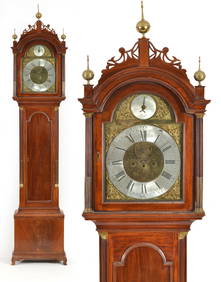
Jun 02Tremont AuctionsSamuel Mulliken mahogany tall case clock with composite brass dial, circa 1790. The Chippendale case$1,200


![Sanson World Atlas, 1659: SANSON D'ABBEVILLE, Nicholas (1600-1667). Cartes Generales de Toutes les Parties du Monde. Paris: The Author and Pierre Mariette, 1658 [but 1659]. Comparables: Arader Galleries, 2015 - $97,600; Christ](https://p1.liveauctioneers.com/1968/250616/130196469_1_x.jpg?height=310&quality=70&version=1654190895)


![WIT, Frederick de (1630-1706). [Composite Atlas].: WIT, Frederick de (1630-1706). [Composite Atlas]. Amsterdam: F. de Wit, [n.d. ma circa 1680]. Bellissimo atlante composito con oltre 117 mappe di cui la maggior parte a doppia pagina e colorate all'ep](https://p1.liveauctioneers.com/3662/102842/52581030_1_x.jpg?height=310&quality=70&version=1492593376)


![[Atlas] SANTINI. Atlas universel: SANTINI, Francesco e Paolo. Atlas universel dressé sur les meilleures cartes modernes 1776.Venezia, Chez P. Santini, s.d. [1776-1780]2 vols. Folio; Contemporary binding in half calf and marbled paper](https://p1.liveauctioneers.com/3336/88749/45475267_1_x.jpg?height=310&quality=70&version=1464790901)


![L'Africa. DE ROSSI / SANSON 1677 old antique vintage map plan chart: TITLE/CONTENT OF MAP: L'Africa [Africa] DATE PRINTED: 1677 IMAGE SIZE: Approx 42.5 x 57.0cm, 16.75 x 22.25 inches (Large) TYPE: Antique 17th century folio atlas map CONDITION: Good; suitable for frami](https://p1.liveauctioneers.com/5584/308981/165185503_1_x.jpg?height=310&quality=70&version=1699996168)


![[MAPS]. HOMANN, Johann Baptist, HOMANN HEIRS, and Georg Matthäus SEUTTER. [Composite Atlas]. (1 of 5)](https://p1.liveauctioneers.com/197/329395/177650530_1_x.jpg?height=282&quality=70&version=1715364962)
![d'Anville (Jean Baptiste Bourguignon) [Untitled Composite Atlas with 102 map sheets], [probably (1 of 3)](https://p1.liveauctioneers.com/5458/329231/177514974_1_x.jpg?height=282&quality=70&version=1715269091)