Sold2017WIT, Frederick de (1630-1706). [Composite Atlas].WIT, Frederick de (1630-1706). [Composite Atlas]. Amsterdam: F. de Wit, [n.d. ma circa 1680]. Bellissimo atlante composito con oltre 117 mappe di cui la maggior parte a doppia pagina e colorate all'epSee Sold Price
Sold2015Magnum Mare del Zur cum InsulaCalifornia by Frederick de Wit (1630-1706), Amsterdam, 1675, copper-engraved mariner's chart, hand-colored in outline, showing California as an island, Tooley #40, with a colorful pictorial cartoucheSee Sold Price
Sold2019AN ANTIQUE MAP, "Poli Arctici et CircumiacentiumAN ANTIQUE MAP, "Poli Arctici et Circumiacentium Terrarum Descriptio Novissima," CIRCA 1676, hand colored engraving on paper, published by Frederick de Wit (1630-1706), a banner cartouche U/L, "GedrucSee Sold Price
Sold2019AN ANTIQUE MAP, "Accuratissima Angliæ Regni et WalliæAN ANTIQUE MAP, "Accuratissima Angliæ Regni et Walliæ Principatus," AMSTERDAM, CIRCA 1680, hand colored engraving on paper, published by Frederick de Wit (1630-1706), showing most of the British IslSee Sold Price
Sold2019De Wit Map of HungaryDE WIT, Frederick (1630-1706). Regni Hungariae, et Regionum, quae ei Quondam Fuere Unitae, ut Transilvaniae, Valachiae, Moldaviae, Serviae, Romaniae, Bulgariae, Bessarabiae, Croatiae, Bosniae, DalmatiSee Sold Price
Sold2017De Wit Map of AfricaTotius Africa Accuratissima Tabula. Frederick de Wit (1629/1630-1706). Engraved map with original hand color. Amsterdam, c. 1660. 19 1/4 x 23 inches visible, 24 3/4 x 28 1/2 inches framedSee Sold Price
Sold2020De Wit Map of Africa ca. 1685Frederick de Wit (ca. 1630 – 1706), "Totius Africae Accuratissima Tabula," Amsterdam, ca. 1685. Hand colored map of Africa. African animals are included throughout the continent, and the decoraSee Sold Price
Sold2023De Wit Map of Zeeland, HollandDE WIT, Frederick (c. 1630-1706). Comitatus Zelandiae tabula... Engraved map with original hand color. Amsterdam, c. 1680. 21 1/2" x 24 3/8" sheet, approx. Antique Map of Zeeland, Netherlands showingSee Sold Price
Sold2017De Wit Portolan Sea Chart of EuropeTotius Europae Victoria... Frederic De Wit (1630-1706). Engraved map with original hand color. Amsterdam, 1675. 20 x 35 1/2 inches sheet, 27 1/2 x 43 inches framed. “The most striking and decorativeSee Sold Price
Sold202117th C. Dutch Map of Southern Spain by F. de Wit**Originally Listed At $300** Fredericum de Wit (Dutch, 1630-1706)."Regnorum Castellae Novae, Andalusiae, Granadae Valentiae, et Murciae" copper engraving with hand coloring issued in Amsterdam, lateSee Sold Price
Sold2021De Witt. Angliae Regni et Walliae Principatus.[England] de Witt, Frederick (1630-1706). "Accuratissima Angliae Regni et Walliae Principatus." Amsterdam. c.1680. Copperplate engraved map. Hand colored cartouche and bordering. Shows most of the BriSee Sold Price
Sold2022De Wit - Nova Orbis Tabula In Lucem Edita, MapFrederick De Wit (circa 1629-1706), Nova Orbis Tabula In Lucem Edita, A.F. De Wit, published by Covens and Mortier, Amsterdam, circa 1720, in two sheets, engraving on laid paper, double hemisphere vieSee Sold Price
Sold2022De Wit, Map of North and South America, c. 1720Property of a Private Collector, Hilton Head Island, SC Description: Frederick De Wit (circa 1629-1706), Nova Orbis Tabula In Lucem Edita, A.F. De Wit, Amsterdam: Covens and Mortier, c. 1720, publSee Sold Price
Sold201717th C Frederick De Wit Handcolored Engraving ChristLarge engraving, hand colored of Frederick De Wit (1629/30-1706), engraver most noted for his maps. This engraving of the Passion of Christ. Signed in type at bottom of engraving and listed place of pSee Sold Price
Sold2022MAP, South America, WitNorthwestern South America & Central America. Frederick de Wit, Novae Hispaniae, Chili, Peruviae, et Guatimalae Littorae, from Orbis Maritimus ofte Zee Atlas, 1680 (circa). Hand Color. This handsome sSee Sold Price
Sold2020WIT, FREDERICK de. Novissima et Accuratissima TotiusWIT, FREDERICK de. Novissima et Accuratissima Totius Americae Descriptio. Double-page engraved map of the Americas showing California as an island. 20x23½ inches sheet size, ample margins; originSee Sold Price
Sold2022MAP- Frederick De. Wit:MAP- Frederick De. Wit: MAP- Frederick De. Wit: NOVISSIMA PRAE CETERISALIIS ACCURATISSIMA REGNORUM ANGLIAE SCOTIAE HIBERNIAE. Ca. 1690, hand coloured and laid down (560x490mm)See Sold Price
Sold2017(MAP, SICILY) DE WIT, FREDERICK. Insula sive regnumMAP, SICILY by DE WIT, FREDERICK, Insula sive regnum Siciliae urbibus praecipuis exornatum. Amsterdam, circa 1680. Hand-colored engraved map of Sicily. With inset plans of Messina, Milazzo and PalermoSee Sold Price
Sold2016An important map of Asia, c1680 by Frederick De WitAn important map of Asia, c1680 by Frederick De Wit depicting the area of Asia, including China, Japan, Tibet, India, Russia, Persia, Arab and more (center folding area repair), 19.5"x23"See Sold Price
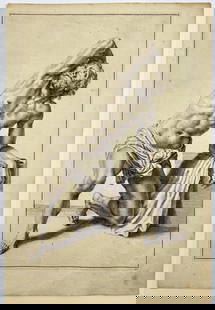
Sold2023Antique Engraving - Frederick de Wit - Female Form - Drawing of Woman FigureTitle/Artist: Antique Engraving - Frederick de Wit - Female Form - Drawing of Woman Figure Medium: Antique engraving originates from "Lumen Picturae: A Classical Drawing Manual" by Frederick de Wit. TSee Sold Price
Sold2020(AFRICA.) Renard, Louis; after De Wit, Frederick.(AFRICA.) Renard, Louis; after De Wit, Frederick. Tractus Littorales Guineae a Promontorio Verde usque ad Sinum Catenbale. Double-page engraved chart of western Africa with a large cartouche depictionSee Sold Price
Sold2023Antique Original Engraving - Drawing of Donkey - Animal Image - Frederick de WitTitle: Antique Original Engraving - Drawing of Donkey - Animal Image - Frederick de Wit Date/Period: 1660-1705 Material: Paper Dimensions: 10” x 14” inches / 24.5 cm x 35 cm Description: ASee Sold Price
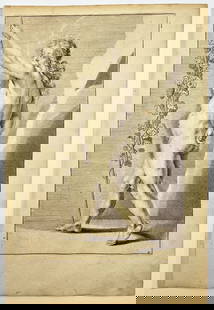
Sold2023Antique Engraving - Male Figure Drawing - Man Figure Sketch - Frederick de WitTitle/Artist: Antique Engraving - Male Figure Drawing - Man Figure Sketch - Frederick de Wit Medium: Antique engraving originates from "Lumen Picturae: A Classical Drawing Manual" by Frederick de Wit.See Sold Price
Sold2017[MAP] FREDERICK DE WIT (DUTCH, 1630-1706)Map of Frankfurt in Hesse, Germany, c. 1680See Sold Price
Jun 07Freeman's | Hindman[MAPS]. HOMANN, Johann Baptist, HOMANN HEIRS, and Georg Matthäus SEUTTER. [Composite Atlas].$15,000
May 30Forum Auctionsd'Anville (Jean Baptiste Bourguignon) [Untitled Composite Atlas with 102 map sheets], [probably£2,000
Jun 06Austin Auction Gallery(2) JOHN DE WIT (20TH C.) ORIENT & FLUME ART GLASS SPIRAL PAPERWEIGHT VASES$150
2 days LeftLucas Milano SRLHendrick de Clerck (Bruxelles 1570 - 1630) attribuito Madonna dell'Annunciazione Olio su tavola€2,600
4 days LeftFreeman's | HindmanCircle Of Esaias van de Velde the Elder (Dutch, 1587-1630) A Merry Company in a Garden$2,000
6 days LeftTrillium Antique Prints & Rare BooksDe Jode, Rare, pub. 1593 - Map of Kingdom of Napoli, Italy (Neapolitani Regni exacta ac diligens$130(3 bids)
6 days LeftTrillium Antique Prints & Rare BooksDe Jode, Rare, pub. 1593 - Map of Hainut, Belgium (Hannoniae Comitatus Descriptio)$100(1 bid)
2 days LeftFleischer's Auctions1755 Map Partie de l'Amerique Septentrionale, qui comprend Le Cours de L'Ohio...$200(3 bids)
Jun 07Freeman's | HindmanHAUY, Rene-Just. Traite de Mineralogie. 1801. FIRST EDITION, SIGNED BY PUBLISHER.$500


![WIT, Frederick de (1630-1706). [Composite Atlas].: WIT, Frederick de (1630-1706). [Composite Atlas]. Amsterdam: F. de Wit, [n.d. ma circa 1680]. Bellissimo atlante composito con oltre 117 mappe di cui la maggior parte a doppia pagina e colorate all'ep](https://p1.liveauctioneers.com/3662/102842/52581030_1_x.jpg?height=310&quality=70&version=1492593376)
![WIT, Frederick de (1630-1706). [Composite Atlas]. First Image](https://p1.liveauctioneers.com/3662/102842/52581030_1_x.jpg?height=300&quality=1&version=1492593376&width=300)
![WIT, Frederick de (1630-1706). [Composite Atlas]. First Image](https://p1.liveauctioneers.com/3662/102842/52581030_1_x.jpg?height=300&quality=95&version=1492593376&width=300)


![De Witt. Angliae Regni et Walliae Principatus.: [England] de Witt, Frederick (1630-1706). "Accuratissima Angliae Regni et Walliae Principatus." Amsterdam. c.1680. Copperplate engraved map. Hand colored cartouche and bordering. Shows most of the Bri](https://p1.liveauctioneers.com/179/209052/106367558_1_x.jpg?height=310&quality=70&version=1624651037)


![[MAP] FREDERICK DE WIT (DUTCH, 1630-1706): Map of Frankfurt in Hesse, Germany, c. 1680](https://p1.liveauctioneers.com/3820/102962/52635987_1_x.jpg?height=310&quality=70&version=1492789342)

![[MAPS]. HOMANN, Johann Baptist, HOMANN HEIRS, and Georg Matthäus SEUTTER. [Composite Atlas]. (1 of 5)](https://p1.liveauctioneers.com/197/329395/177650530_1_x.jpg?height=282&quality=70&version=1715364962)
![d'Anville (Jean Baptiste Bourguignon) [Untitled Composite Atlas with 102 map sheets], [probably (1 of 3)](https://p1.liveauctioneers.com/5458/329231/177514974_1_x.jpg?height=282&quality=70&version=1715269091)


