Sold2020Olney's Atlas with Independent TexasHeading: (Atlas) Author: Olney, J. Title: Olney's School Atlas Place Published: New York Publisher:Robinson, Pratt & Co. Date Published: 1841 Description: Illustrated with 1See Sold Price
Sold20231844. United States with independent Texas. 1844 by OlneyTitle: 1844. United States with independent Texas. 1844 by Olney Date/Period: 1844 Materials: Steel engraved Size: 19 x 12” Important aspect of this map is the independence Republic of Texas. ShSee Sold Price
Sold2020With U.S. map showing "maximum" TexasHeading: (Atlas) Author: Olney, J. Title: Olney's School Atlas Place Published: New York Publisher:Pratt, Woodford & Co. Date Published: 1844 Description: With 16 hand-colored coSee Sold Price
Sold20231844. North America. By OlneyTitle: 1844. North America. By Olney Date/Period: 1844 Materials: Steel engraved Size: 12” x 10” Texas as an independent Republic. Oregon territory claim is above the 49th parallel. AlaskaSee Sold Price
Sold2022Map of Texas, Indian Terr., Mississippi, etc.- OlneyNice hand-colored school atlas map of the near Southwest. “No. 8 Mississippi, Arkansas, Louisiana, Texas, Indian Territory.” From Olney’s 1849 school atlas. Clean with a tiny spot iSee Sold Price
Sold2024Tanner's North America independent TexasHeading: (North America) Author: Tanner, Henry Schenck Title: North America Place Published: Philadelphia Publisher: Date Published: 1836-[1845] Description: Engraved map, hand-coloSee Sold Price
Sold2020Scarce German map of independent Texas 1843Heading: (Texas) Author: Flemming, Carl Title: Texas Place Published: Glogau Publisher: Date Published: 1843 Description: Lithographed map, hand-colored in outline. 39.5x32 cm. (See Sold Price
Sold2020North America with large independent TexasHeading: Author: Burgess, Daniel Title: Map of North America Designed to Accompany Smith's Geography for Schools Place Published: New York Publisher: Date Published: 1839 Description:See Sold Price
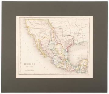
Sold2020Mexico with a large independent Texas, c.1845 mapHeading: Author: Gilbert, James Title: Mexico & Texas Place Published: London Publisher:Grattan & Gilbert Date Published: c.1845 Description: Engraved map, hand-colored in outliSee Sold Price
Sold2017Meyer: Antique Map of Mexico & Independent Texas, 1845Map: Neueste Karte von Mexico Cartographer: Bibliographischen Instituts. Place & Date: Hildburghausen / 1845 Size: 14 1/8" x 11 3/8" Condition: original outline color; overall age toning; water stainsSee Sold Price
Sold2020North America with independent TexasHeading: Author: Dufour, Adolphe Hippolyte Title: [Amerique du Nord] Place Published: [Paris] Publisher:Imp. de N. Rémond Date Published: c.1845 Description: Engraved map, hand-See Sold Price
Sold2020Tallis map of U.S. with independent TexasHeading: (Texas) Author: Tallis, John Title: United States Place Published: London Publisher: Date Published: [1850] Description: Engraved map, hand-colored in outline; with 7 unSee Sold Price
Sold2020Tanner's North America independent TexasHeading: (Texas) Author: Tanner, Henry Schenck Title: North America Place Published: Philadelphia Publisher: Date Published: 1836-[1845] Description: Engraved map, hand-coloSee Sold Price
Sold2020United States with large independent TexasHeading: (Texas) Author: Chambers, W. & R. Title: United States Place Published: Edinburgh Publisher: Date Published: 1841 Description: Engraved map, hand-colored in outlineSee Sold Price
Sold2022Map of North America with Independent TexasSteel-engraved map of North America with Texas shown as an independent country, hand-colored in outline. Published by T. Tegg, London, circa 1845. [10" H x 8 1/2" W]. Slightly toned, near fine.See Sold Price
Sold2022(REPUBLIC OF TEXAS.) Alexander Keith Johnston. United States and Texas.(REPUBLIC OF TEXAS.) Alexander Keith Johnston. United States and Texas. Double-page engraved map of the eastern United States and an independent Texas. 21x25½ inches sheet size, wide margins; oriSee Sold Price
Sold2022(REPUBLIC OF TEXAS.) John M. Niles; and Lorraine T. Pease. A Map of Mexico and the Republic of(REPUBLIC OF TEXAS.) John M. Niles; and Lorraine T. Pease. A Map of Mexico and the Republic of Texas. Hand-colored engraved map of Mexico, an independent Texas, and part of the American southeast. 13&See Sold Price
Sold2022Kenneth Zonker (American/Texas, 1941-2002), Abstract Flower Watercolor, 1983Kenneth Zonker (American/Texas, 1941-2002), abstracted flower, 1983, watercolor on paper, sight: 26 x 18", frame: 37 x 30" Zonker was born in Olney, Texas in 1941. He grew up in Venezuela, where hisSee Sold Price
Sold20231842 Thierry Map of North America -- Amerique SeptentrionaleTitle: 1842 Thierry Map of North America -- Amerique Septentrionale Cartographer: Thierry Year / Place: 1842 Map Dimension (in.): 8.2 X 10.6 in. This is a lovely map of North America. Independent TexaSee Sold Price
Sold2022Antique 1844 Hand Colored Olney's School Atlas Published by Pratt, Woodford, and Co.This is an antique Olney's School Atlas published in 1844 by Pratt, Woodford and Co of New York. The softbound volume features hand colored maps of regions of the United States and the world. CharmingSee Sold Price
Sold2018[ATLAS]. OLNEY, Jesse (1798-1872).[ATLAS]. OLNEY, Jesse (1798-1872). A New and Improved School Atlas, to Accompany the Practical System of Modern Geography. New York: Robinson, Pratt & Co, ca 1831. 4to (296 x 240). 12 hand-colored engSee Sold Price
Sold2023Rare Antique OLNEY'S SCHOOL ATLAS, Maps 1844We have included quality images to show their condition. This lot is located in Boca Raton, Fl and its shipment will be made directly by Artelisted. Shipping insurance is the responsibility of the buySee Sold Price
Sold2022Scarce U. S. w/huge Texas & disputed northern U.S. border., 1844The scarcer version of the single page North America maps by Jesse Olney with Texas extending its long stovepipe panhandle north almost to present-day Wyoming. Illustrates the extreme northern borderSee Sold Price
Jun 02Schilb Antiquarian Rare Books1849 TEXAS 1ed Mexican War Porter Annexation Mexico Americana Peace Treaties$88(4 bids)
Jun 08Simpson Galleries, LLC.JULIUS BIEN (1826-1909) AN AMERICAN CIVIL WAR RECONNAISSANCE MAP, "Map of Texas and Part of New$100
Jun 08Simpson Galleries, LLC.TWO AMERICAN MAPS, "Texas," AND "Mexico," J.H. COLTON, NEW YORK, CIRCA 1854-1856$150
Jun 08Simpson Galleries, LLC.DON AND CHERYL OLNEY (American b. 1946 and b. 1947) A DIPTYCH, "Two Hearts," 2005$50
1 day LeftVogt Auction TexasHerend (Hungary) "Queen Victoria" Pattern Porcelain DInner Service Set$1,100(2 bids)


![Tanner's North America independent Texas: Heading: (North America) Author: Tanner, Henry Schenck Title: North America Place Published: Philadelphia Publisher: Date Published: 1836-[1845] Description: Engraved map, hand-colo](https://p1.liveauctioneers.com/642/319971/171838592_1_x.jpg?height=310&quality=70&version=1708136548)


![North America with independent Texas: Heading: Author: Dufour, Adolphe Hippolyte Title: [Amerique du Nord] Place Published: [Paris] Publisher:Imp. de N. Rémond Date Published: c.1845 Description: Engraved map, hand-](https://p1.liveauctioneers.com/642/174090/87617771_1_x.jpg?height=310&quality=70&version=1595023143)
![Tallis map of U.S. with independent Texas: Heading: (Texas) Author: Tallis, John Title: United States Place Published: London Publisher: Date Published: [1850] Description: Engraved map, hand-colored in outline; with 7 un](https://p1.liveauctioneers.com/642/174090/87617797_1_x.jpg?height=310&quality=70&version=1595023143)
![Tanner's North America independent Texas: Heading: (Texas) Author: Tanner, Henry Schenck Title: North America Place Published: Philadelphia Publisher: Date Published: 1836-[1845] Description: Engraved map, hand-colo](https://p1.liveauctioneers.com/642/171046/86179542_1_x.jpg?height=310&quality=70&version=1591835061)

![Map of North America with Independent Texas: Steel-engraved map of North America with Texas shown as an independent country, hand-colored in outline. Published by T. Tegg, London, circa 1845. [10" H x 8 1/2" W]. Slightly toned, near fine.](https://p1.liveauctioneers.com/1221/243451/126278661_1_x.jpg?height=310&quality=70&version=1649868014)


![[ATLAS]. OLNEY, Jesse (1798-1872).: [ATLAS]. OLNEY, Jesse (1798-1872). A New and Improved School Atlas, to Accompany the Practical System of Modern Geography. New York: Robinson, Pratt & Co, ca 1831. 4to (296 x 240). 12 hand-colored eng](https://p1.liveauctioneers.com/197/119933/61100813_1_x.jpg?height=310&quality=70&version=1522758048)


