Sold2020North America with large independent TexasHeading: Author: Burgess, Daniel Title: Map of North America Designed to Accompany Smith's Geography for Schools Place Published: New York Publisher: Date Published: 1839 Description:See Sold Price
Sold2024Tanner's North America independent TexasHeading: (North America) Author: Tanner, Henry Schenck Title: North America Place Published: Philadelphia Publisher: Date Published: 1836-[1845] Description: Engraved map, hand-coloSee Sold Price
Sold2020Tanner's North America independent TexasHeading: (Texas) Author: Tanner, Henry Schenck Title: North America Place Published: Philadelphia Publisher: Date Published: 1836-[1845] Description: Engraved map, hand-coloSee Sold Price
Sold20231842 Thierry Map of North America -- Amerique SeptentrionaleTitle: 1842 Thierry Map of North America -- Amerique Septentrionale Cartographer: Thierry Year / Place: 1842 Map Dimension (in.): 8.2 X 10.6 in. This is a lovely map of North America. Independent TexaSee Sold Price
Sold2020North America with independent TexasHeading: Author: Dufour, Adolphe Hippolyte Title: [Amerique du Nord] Place Published: [Paris] Publisher:Imp. de N. Rémond Date Published: c.1845 Description: Engraved map, hand-See Sold Price
Sold2022Map of North America with Independent TexasSteel-engraved map of North America with Texas shown as an independent country, hand-colored in outline. Published by T. Tegg, London, circa 1845. [10" H x 8 1/2" W]. Slightly toned, near fine.See Sold Price
Sold2018Spanish North America. THOMSON. Texas, Mexico &TITLE/CONTENT OF MAP: 'Spanish North America [northern part]' A large map of Texas, Mexico and the American Southwest, published in Edinburgh by John Thompson, based on the explorations of Humboldt anSee Sold Price
2024Spanish North America. THOMSON. Texas, Mexico & Southwestern USA 1817 mapTITLE/CONTENT OF MAP: Spanish North America [northern part] A large map of Texas, Mexico and the American Southwest, published in Edinburgh by John Thompson, based on the explorations of Humboldt andSee Sold Price
Sold2023Spanish North America. THOMSON. Texas, Mexico & Southwestern USA 1830 mapTITLE/CONTENT OF MAP: Spanish North America [northern part] A large map of Texas, Mexico and the American Southwest. There are extensive observations of Native American Indian settlements and huntingSee Sold Price
Sold2019N. Amer. map w/huge Texas, New Calif. Terr.Reserve Reduced! Interesting map of North America showing a huge Texas, large Oregon Territory and New California. Dates to at least 1850 because that’s when New Mexico became a territory. Drawn andSee Sold Price
Sold20231844. North America. By OlneyTitle: 1844. North America. By Olney Date/Period: 1844 Materials: Steel engraved Size: 12” x 10” Texas as an independent Republic. Oregon territory claim is above the 49th parallel. AlaskaSee Sold Price
Sold2018NORTH AMERICA.Texas Republic.Mexican California.RussianTITLE/CONTENT OF MAP: 'NORTH AMERICA, South to Panama.' The Republic of Texas is shown as an independent state as it existed between 1836 and 1845; it shows the US-Mexican border prior to the Mexican-See Sold Price
Sold2020NORTH AMERICA.Texas Republic.Mexican California.RussianTITLE/CONTENT OF MAP: 'NORTH AMERICA, South to Panama.' The Republic of Texas is shown as an independent state as it existed between 1836 and 1845; it shows the US-Mexican border prior to the Mexican-See Sold Price
Sold2018North AmericaTitle/Content of Map: North America Date Printed: 1851 ca. Cartographer: SWANSTON, G. H. Size: 10.6X8.5 Very large Oregon, Utah and New Mexico territories. Texas has present boundaries. Margins browneSee Sold Price
Sold20231755 Robert De Vaugondy Map of North America Large1755 Robert De Vaugondy Map of America. Mid-Atlantic, New York, New Jersey, Pennsylvania Virginia, Maryland, New England, Carolina and Ohio. Partie De L'Amerique Septentrionale. Map in matte is aboutSee Sold Price
Sold2023NORTH AMERICA. Texas Republic. Mexican California. Russian America SDUK 1851 mapTITLE/CONTENT OF MAP: 'NORTH AMERICA' The borders printed on the map reflect national boundaries as they existed between 1836 and 1845 during which period the map was engraved, including the RepublicSee Sold Price
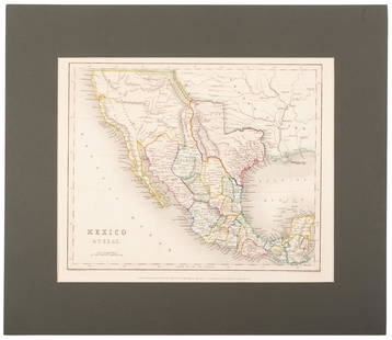
Sold2020Mexico with a large independent Texas, c.1845 mapHeading: Author: Gilbert, James Title: Mexico & Texas Place Published: London Publisher:Grattan & Gilbert Date Published: c.1845 Description: Engraved map, hand-colored in outliSee Sold Price
Sold2020United States with large independent TexasHeading: (Texas) Author: Chambers, W. & R. Title: United States Place Published: Edinburgh Publisher: Date Published: 1841 Description: Engraved map, hand-colored in outlineSee Sold Price
Sold2023Pinkerton, John 1811 Antique Map. Spanish North America. Texas etc (Faults)"Spanish Dominions in North America" Copper Engraved Map Published 1811, London for "Modern Geography. A Description of the Empires, Kingdoms, States and Colonies..." by John Pinkerton. Paper Size: 11See Sold Price
Sold2022(COLONIAL NORTH AMERICA.) John Senex, Charles Price, and John Maxwell. North America.(COLONIAL NORTH AMERICA.) John Senex, Charles Price, and John Maxwell. North America. Large engraved map of North America on two sheets of laid paper joined. 39x26¾ inches overall, wide margins;See Sold Price
Sold2021[Native Americana, Hand-Colored Lithograph]"Hoo-Wan-Ne-Ka, A Winnebago Chief." Philadelphia: J. T. Bowen, 1841. From McKenney and Hall's folio edition of the History of the Indian Tribes of North America. Large folio sheet, 19.25" x 13.75". AcSee Sold Price
Sold2021America.- , Act (An) to enable His Majesty to concludeAmerica.- Act (An) to enable His Majesty to conclude a Peace or Truce with certain Colonies in North America, large woodcut royal arms to title, woodcut head-piece and decorative initial, lightly browSee Sold Price
Sold2022MCKENNEY & HALL PRINT, "NOT-CHI-MI-NE".Published by F.W. Greenough, Philadelphia, 1838, printed by Bowen. From "The History of the Indian Tribes of North America". Large folio hand colored lithograph in good colors of "An Ioway Chief". IniSee Sold Price
Sold2022TWO MCKENNEY & HALL PRINTS.Published by F.W. Greenough, Philadelphia, 1838, printed by Bowen. From "The History of the Indian Tribes of North America". Large folio hand colored lithographs with attached text pages. "Chittee YohSee Sold Price
BonhamsMITCHELL (SAMUEL AUGUSTUS) A New Universal Atlas Containing Maps of the Various Empires, Kingdom...£1,300
Jun 08Early American History Auctions1853 Map of Portion of British North America and Gulf of St. Lawrence, by Henry Perley$260


![Tanner's North America independent Texas: Heading: (North America) Author: Tanner, Henry Schenck Title: North America Place Published: Philadelphia Publisher: Date Published: 1836-[1845] Description: Engraved map, hand-colo](https://p1.liveauctioneers.com/642/319971/171838592_1_x.jpg?height=310&quality=70&version=1708136548)
![Tanner's North America independent Texas: Heading: (Texas) Author: Tanner, Henry Schenck Title: North America Place Published: Philadelphia Publisher: Date Published: 1836-[1845] Description: Engraved map, hand-colo](https://p1.liveauctioneers.com/642/171046/86179542_1_x.jpg?height=310&quality=70&version=1591835061)

![North America with independent Texas: Heading: Author: Dufour, Adolphe Hippolyte Title: [Amerique du Nord] Place Published: [Paris] Publisher:Imp. de N. Rémond Date Published: c.1845 Description: Engraved map, hand-](https://p1.liveauctioneers.com/642/174090/87617771_1_x.jpg?height=310&quality=70&version=1595023143)
![Map of North America with Independent Texas: Steel-engraved map of North America with Texas shown as an independent country, hand-colored in outline. Published by T. Tegg, London, circa 1845. [10" H x 8 1/2" W]. Slightly toned, near fine.](https://p1.liveauctioneers.com/1221/243451/126278661_1_x.jpg?height=310&quality=70&version=1649868014)
![Spanish North America. THOMSON. Texas, Mexico &: TITLE/CONTENT OF MAP: 'Spanish North America [northern part]' A large map of Texas, Mexico and the American Southwest, published in Edinburgh by John Thompson, based on the explorations of Humboldt an](https://p1.liveauctioneers.com/5584/132181/67157544_1_x.jpg?height=310&quality=70&version=1543975692)
![Spanish North America. THOMSON. Texas, Mexico & Southwestern USA 1817 map: TITLE/CONTENT OF MAP: Spanish North America [northern part] A large map of Texas, Mexico and the American Southwest, published in Edinburgh by John Thompson, based on the explorations of Humboldt and](https://p1.liveauctioneers.com/5584/320546/172232524_1_x.jpg?height=310&quality=70&version=1709072904)
![Spanish North America. THOMSON. Texas, Mexico & Southwestern USA 1830 map: TITLE/CONTENT OF MAP: Spanish North America [northern part] A large map of Texas, Mexico and the American Southwest. There are extensive observations of Native American Indian settlements and hunting](https://p1.liveauctioneers.com/5584/309982/165835454_1_x.jpg?height=310&quality=70&version=1700599538)


![[Native Americana, Hand-Colored Lithograph]: "Hoo-Wan-Ne-Ka, A Winnebago Chief." Philadelphia: J. T. Bowen, 1841. From McKenney and Hall's folio edition of the History of the Indian Tribes of North America. Large folio sheet, 19.25" x 13.75". Ac](https://p1.liveauctioneers.com/3532/226268/116906080_1_x.jpg?height=310&quality=70&version=1636936110)


