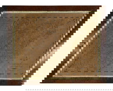
Sold2023Map Of Missouri 1820 Fender and Sears 17x11Map Of Missouri 1820 Fender and Sears 17x11See Sold Price
Sold2023First state of an important map of the Trans-Mississippi WestMathew Carey's map, Missouri Territory formerly Louisiana, is one of the seminal maps of the period and the first atlas map to provide the cartographic detail derived from the return of the Lewis & ClSee Sold Price
Sold20221820 MAP OF SALEM and 1875 of SALEM HARBOR28 x 36 inches and smaller Condition: Good, stiff, tearsSee Sold Price
Sold2024Schmidt 1820 Map of America [179119]America. Folded map in original slip case, cloth back. J. M. F. Schmidt, Berlin. Published 1820. Shows California as complete (not an island), but does not show California missions. The map is in 16 fSee Sold Price
Sold20201861 Civil War Memorabilia CSA Orders INDIANS Bond1861 Civil War Memorabilia CSA Orders INDIANS Bond Stamp Map Newspaper Missouri A unique collection of Civil War Memorabilia of Confederate Bonds, Confederate Postage, war orders of charges against reSee Sold Price
Sold2023MARBLE BUST OF CONGRESSMAN HENRY CLAY (1777-1852)Unsuccessfully sought the U.S. presidency. Engineered the Missouri Compromise in 1820. Presented in a velvet-lined shadow box frame. unsigned 12 1/2 x 10 3/4 inches.See Sold Price
Sold2023Empire Ormolu & Bronze Fender, Circa 1810Empire Ormolu & Bronze Fender, Circa 1800-1820. Bronze rod with artichoke finials resting on winged griffins and draping embossed floral buntings. Flanked by two urns with flaming finials. Support barSee Sold Price
Sold2018Benjamin Warner Map of United States Philadelphia, 1820Benjamin Warner's map of the United States of America corrected and improved from the best authorities, 1820. Published by B.Warner, Philadelphia. Dimensions: Framed: 21 inches x 28.5 inches, Sight: 1See Sold Price
Sold2023FEDERAL BRASS AND WIRE FIREPLACE FENDER.Ca. 1800-1820 serpentine front fire place fender with three brass steeple top finials, copper top rail with scrolled wirework front, 16”H x 52.5”L x 17”D.See Sold Price
Sold2024T&J CALDWELL CALLAWAY CO MISSOURI EARLY OVOID STONEWAREThe nicely fired ovoid form stoneware storage jar from the early 19th century was thrown in Callaway County which was organized in 1820, a year before Missouri became a state, and named for Captain JaSee Sold Price
Sold2022Early American Map Lewis Clark Major Long US Missouri Arkansas TerritoryTitle: Early American Map Lewis Clark Major Long US Missouri Arkansas Territory Description:Early American Map Lewis Clark Major Long US Missouri Arkansas Territory With some hand coloring. Early GarlSee Sold Price
Sold2022Munson's A New Map of the Western Rivers, 1846MUNSON, Sam[ue]l B[ishop] (1806-1880). A New Map of the Western Rivers. Or Travellers Guide Exhibiting the Mississippi, Missouri, Ohio, and Illinois Rivers, with all the Principal Towns, Islands & DisSee Sold Price
Sold201719th Century Hand Painted Terrestrial MapDescription - A 19th century hand painted, watercolor terrestrial map of the world. Signed "Camilla Ketchams. Delineator. Pennington Academy, September 4th, 1820." Dimensions - Frame - 11.5" x 14.5"See Sold Price
Sold2016Schoolcraft explores the west 1821 with mapHeading: Author: Schoolcraft, Henry R. Title: Journal of a Tour into the Interior of Missouri and Arkansaw, from Potosi, or Mine à Burton, in Missouri Territory, in a South-West Direction, toward thSee Sold Price
Sold2022MURRY SEARS DRAGSTER PEDAL CARAll original Murry Pedal Car. Has great colors and Hot Rod look. Has exhaust coming out side of hood. One side is loose but present. Missing 1 fender marker. A great looking toy! 35" ExcellentSee Sold Price
Sold2017Map Of Charleston District, S.C.Map Of Charleston District, S.C. Surveyed by Charles Vignoles & Henry Ravenel. 1820 surveyed. Improved, 1825. Ink on large paper. Some very minor areas of discoloration and minor paper creasing, otherSee Sold Price
Sold2023Large map engraving of Paris 1834 Herisson CartographerEustache Hérisson (1759 – 18? ) was a French cartographer with an abundant body of work , particularly active in the years 1810-1820, pupil of Bonne, his work has been extensively reissuedSee Sold Price
Sold2022Atlas; Being a General Guide to History. 1820.[Map/Atlas] Atlas; Being a General Guide to History...M. Carey & Son, Philadelphia, 1820. Folio. Quarter leather over original boards. Complete with 71 handcolored maps, tables, including 28 double paSee Sold Price
Sold2023Northern provinces of the United States. THOMSON. District of Main[e] 1817 mapTITLE/CONTENT OF MAP: 'Northern provinces of the United States' The map shows the "District of Maine", prior to its accession to the Union as the state of Maine in 1820. Some Native American Indian viSee Sold Price
Sold2023CALLIGRAPHY MAP OF THE US BY CHARLES CLIPP, KINGSTON ACADEMY , 1820 (16 1/2" X 20 1/2" )CALLIGRAPHY MAP OF THE US BY CHARLES CLIPP, KINGSTON ACADEMY , 1820 (16 1/2" X 20 1/2" )See Sold Price
Sold2022Silvertone 1452 - 1967 Fender Jaguar OutlawSilvertone 1452 - 1967 Fender Jaguar Outlaw. The auction is for ONE guitar - the SILVERTONE guitar. Owned by Jerry Garcia's Lawyer. I've been a huge fan of vintage Danelectro, Silvertone and Sears eleSee Sold Price
Sold20181855 Smith Map of the MidWest -- Guide through Ohio,Title/Content of Map: 1855 Smith Map of the MidWest -- Guide through Ohio, Michigan, Indiana, Illinois, Missouri, Wisconsin & Iowa Showing the Township Lines of the United States Surveys Date Printed:See Sold Price
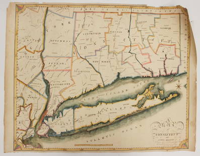
Sold2023EARLY CONNECTICUT MAPHand drawn and colored; "Connecticut and Parts Adjacent", "drawn by Miss. Elizabeth L. Tredwell" "Christ Church Academy 1820", several edge tears; 23" x 30", F-GSee Sold Price
Sold2020Approximately 50 Antique Service Station Road MapsCirca 1920s-30s, Includes Nebraska, Michigan, Missouri, Iowa, Standard Oil, Sinclair, Shell, and MoreSee Sold Price
2 days LeftJasper521855 Gunnison Map of Missouri and Kansas -- Map No. 1 From the Western Boundary of Missouri to the$55
2 days LeftJasper521852 Owen Map of The Missouri River from Upriver the Platte to Ft. Lawenworth -- Sections of the$45
2 days LeftRapid Estate Liquidators and Auction GalleryUS Post Lewis And Clark First Day Stamp Sheet Bundle$50
5 days LeftSimpson Galleries, LLC.J.H. Young (1792-1870) AN AMERICAN FEDERAL PERIOD MAP, "Mitchell's Travellers Guide Through the$500
BonhamsLINFORTH (JAMES, EDITOR) Route from Liverpool, to Great Salt Lake Valley Illustrated...by Freder...£1,400
5 days LeftHolabird Western Americana CollectionsMills, Post & White Silver Stock Issued to George Hearst [181285]$200
4 days LeftFreeman's | HindmanHARMON, Daniel Williams. A Journal of Voyages and Travels in the Interiour of North America. 1820.$450(2 bids)
Jun 14DuMouchellesWilliam Barker (American, 1770-1805) And Various Engravers Hand Colored Engraved Maps Ca. 18th/19th$50
1 day LeftJasper52Abbeville and the Collegiate Church of Saint-Vulfran, France - Drawing dated 1864$70
5 days LeftTrillium Antique Prints & Rare BooksAudubon, Imperial Folio - PAIR of Mouse Lithographs$375
BonhamsCRUIKSHANK (GEORGE) The Humorist: A Collection of Entertaining Tales, Anecdotes, Repartees..., 4...£10
BonhamsCHAPBOOK The Paths of Learning Strewed with Flowers or English Grammar Illustrated, FIRST EDITIO...£10
BonhamsROWLANDSON (THOMAS) [COMBE (WILLIAM)] Three Tours of Dr Syntax], 3 vol., 1819-1821--Poetical Mag...£10
BonhamsSMITH (CHARLES HAMILTON) The Ancient Costume of Great Britain and Ireland, from the Seventh to t...£10


![Schmidt 1820 Map of America [179119]: America. Folded map in original slip case, cloth back. J. M. F. Schmidt, Berlin. Published 1820. Shows California as complete (not an island), but does not show California missions. The map is in 16 f](https://p1.liveauctioneers.com/2699/324080/174413242_1_x.jpg?height=310&quality=70&version=1711485545)


![Munson's A New Map of the Western Rivers, 1846: MUNSON, Sam[ue]l B[ishop] (1806-1880). A New Map of the Western Rivers. Or Travellers Guide Exhibiting the Mississippi, Missouri, Ohio, and Illinois Rivers, with all the Principal Towns, Islands & Dis](https://p1.liveauctioneers.com/1968/250616/130196575_1_x.jpg?height=310&quality=70&version=1654190895)


![Atlas; Being a General Guide to History. 1820.: [Map/Atlas] Atlas; Being a General Guide to History...M. Carey & Son, Philadelphia, 1820. Folio. Quarter leather over original boards. Complete with 71 handcolored maps, tables, including 28 double pa](https://p1.liveauctioneers.com/179/268856/140616131_1_x.jpg?height=310&quality=70&version=1668545725)
![Northern provinces of the United States. THOMSON. District of Main[e] 1817 map: TITLE/CONTENT OF MAP: 'Northern provinces of the United States' The map shows the "District of Maine", prior to its accession to the Union as the state of Maine in 1820. Some Native American Indian vi](https://p1.liveauctioneers.com/5584/309982/165835410_1_x.jpg?height=310&quality=70&version=1700599538)


![Mills, Post & White Silver Stock Issued to George Hearst [181285] (1 of 2)](https://p1.liveauctioneers.com/2699/331499/178846159_1_x.jpg?height=282&quality=70&version=1717095214)


![ROWLANDSON (THOMAS) [COMBE (WILLIAM)] Three Tours of Dr Syntax], 3 vol., 1819-1821--Poetical Mag... (1 of 2)](https://p1.liveauctioneers.com/1043/319451/178359243_1_x.jpg?height=282&quality=70&version=1716978907)


