Sold2023EARLY CONNECTICUT MAPHand drawn and colored; "Connecticut and Parts Adjacent", "drawn by Miss. Elizabeth L. Tredwell" "Christ Church Academy 1820", several edge tears; 23" x 30", F-GSee Sold Price
Sold2016EARLY MAP OF CONNECTICUT BY JOHN REIDFROM THE BEST AUTHORITIES"; ENGRAVED FOR THE AMERICAN EDITION OF WINTERBOTHAM'S HISTORY OF AMERICA, PUBLISHED BY JOHN REID, NEW YORK (2 SMALL BLEACH SPOTS LOWER LEFT & RIGHT); 14 1/2" X 17 1/2See Sold Price
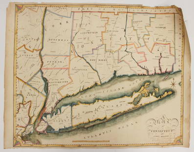
Sold2023MAP, Connecticut, ReidConnecticut. John Reid, Connecticut from the Best Authorities, from Winterbotham's History of America, 1796 (circa). Black & White. This early and uncommon map of Connecticut was engraved by BenjaminSee Sold Price
Sold20221796 Reid Map of Connecticut -- Connecticut from the Best AuthoritiesTitle: 1796 Reid Map of Connecticut -- Connecticut from the Best Authorities Cartographer: J Reid Year/Place: 1796 Dimensions: 13.9 X 17.1 in. Description: This is an excellent, early and uncommon mapSee Sold Price
Sold2023Map of Connecticut And Rhode Island 1780This early map is titled 'A New and accurate Map of Connecticut and Rhode Island. from the best Authorities' published in the Universal Magazine in 1780. The map features Long Island Sound and NarragaSee Sold Price
Sold2023Scarce 1846/48 map of Connecticut by MitchellGreat and authentic map of Connecticut from the 1848 New Universal Atlas by S. Augustus Mitchell. Early Mitchell atlas maps are becoming harder and harder to find—they rarely appear at auction. TheySee Sold Price
2022Scarce 1846/48 map of Connecticut by MitchellGreat and authentic map of Connecticut from the 1848 New Universal Atlas by S. Augustus Mitchell. Early Mitchell atlas maps are becoming harder and harder to find—they rarely appear at auction.See Sold Price
Sold2024Very scarce 1833 Finley map of Rhode IslandVery uncommon to find an early 19th century map of Rhode Island depicted by itself, as most atlases showed it along with Massachusetts and Connecticut. Excellent antique map of Rhode Island hand colorSee Sold Price
Sold20243 Engraved Maps Rhode Island, Connecticut, Mass3 engraved maps. F.W. Beers & Co. Somerset Village, Massachusetts, circa late 1800s, 14 1/2" x 11" (with frame 19 1/4" x 15 3/4"); Rhode Island, circa late 18th-early 19th century, 7 1/2" x 6 3/8" (wiSee Sold Price
Sold20201836 Church History Marsh Jews Illustrated Color MAPS1836 Church History Marsh Jews Illustrated Color MAPS Pagans Pilgrims Quakers John Marsh was a minister of a church in Haddam, Connecticut in the late 18th and early 19th centuries. At Haddam, Marsh pSee Sold Price
Sold2023Mt. Tom Summit House Holyoke Massachusetts promotional flyer from early 1900sA folding promotional flyer for Mt. Tom Summit House, the entire Connecticut Valley and the Holyoke Street Railway Company in Holyoke Massachusetts featuring a map encompassing part of Long Island NewSee Sold Price
Sold2020Two Small Framed Early Mapsincluding Connecticut and Virginia. Not examined out of frames. Largest frame size: 11 1/3" high, 13 3/4" wide. Stains, toning, creases. Provenance: Property of a Madison, CT Collector. VirSee Sold Price
Sold2023Early Map of Tennessee, Daniel Smith, 1795A MAP OF THE TENNASSEE [sic] GOVERNMENT FORMERLY PART OF NORTH CAROLINA TAKEN CHIEFLY FROM SURVEYS BY GENL. D. SMITH & OTHERS, drawn by Daniel Smith, engraved by Joseph T. Scott, for "General Atlas FoSee Sold Price
Sold2017America, Rare Early Map of the Americas"America", Rare Early Map of the Americas by Jodocus Hondius (Flemish/Dutch, 1563-1612) for a French edition of Mercator's Atlas, North and South America, hand-colored copper engraved map, published ASee Sold Price
Sold2022EARLY MAP "AMERICA"John Speede 1626, Thomas Bassett / Richard Chillwell, Abraham Goos; "The Description of America", hand colored, center fold, slight foxing, framed size 19" x 23 1/2", G-G+See Sold Price
Sold2023Album of Early Maps and Ephemera Related to CubaA collectors album of maps and prints related to Cuba. There are total of 70 pieces, from the 16th to the 20th centuries. Highlights include works by Theodor de Bry, a 1561 map of Cuba by Ruscelli, aSee Sold Price
Sold2022EARLY MAP OF BRITAINJohn Speede / Thomas Basett, bookplate "Sanon Heptarchy" on reverse, hand colored, center fold, slight toning, framed size 19" x 23 1/2", G-G+See Sold Price
Sold2023Fine Early Connecticut Double Candle BoxFine early double slide top candle box with heart cut out handle and panel molded lids. Probably New London, Connecticut, 18th century. Fine early 19th century painted surface. Dovetail and forged naiSee Sold Price
Sold2022LARGE EARLY MAP"The Washington Map of The United States", 1861, approximate size 69 1/2" x 69", with early thin linen backingSee Sold Price
Sold2016Early Map: "A New Map Of North America...."Early map: "A New Map Of North America Showing its Principal Divisions....Dedicated To His Highness William Duke Of Gloucester...". Dated 1573. Sight 15" x 19 1/2".See Sold Price
Sold2022EARLY MAP OF AFRICA"Africae" "Newly Done into English John Speede / G. Humble 1626" engraved by Abraham Goos, bookplate "The Description of Africa" on reverse, hand colored; minor tear, foxing, toning, tape marks; frameSee Sold Price
Sold2021Early Map of Bexar County, TXEarly map of Bexar County, TX, showing original land grants, framed frame: 30"h x 34"w Provenance: A San Antonio, TX Collection We happily provide seamless shipping services on everything we sell.See Sold Price
Sold2023Extremely scarce and early map of Ohio, M. Carey 1814One of the most influential early maps of Ohio and the first large format map of Ohio to appear in an atlas. This 1816 example is the identical map that appeared in Carey’s 1814 General Atlas.See Sold Price
Sold2016Early Map of The Michigan Territory by CareyThe Upper Territories of the United States, 1814. Matthew Carey (1760-1839). Engraved map with original hand color in outline. Philadelphia, 1814. 22 x 17 1/4 inches sheet. The map reflects a very earSee Sold Price
11 hrs LeftTrillium Antique Prints & Rare BooksPtolemy & Magini, pub. 1620 - 3 Maps of Italy: Rome, Naples, Lombardia$55(2 bids)
11 hrs LeftTrillium Antique Prints & Rare BooksPtolemy & Magini, pub. 1620 - 4 Maps of European Countries: Spain, Portugal, France, & Greece$50
4 days LeftJasper521652 Sanson Map of Parts od Southeast Asia -- Les Isles de la Sonde. Entre Lesquelles sont Sumatra,$200
5 days LeftThe Bidder AuctionsJerusalem city map - ie heilige statt Jerusalem contrafehtet nach form und gestalt - 16th century$100
Jun 14Eldred'sEDWARD MILLER & CO. SLAG PANEL TABLE LAMP Meriden, Connecticut, Early to Mid-20th Century Height$70


![Early Map of Tennessee, Daniel Smith, 1795: A MAP OF THE TENNASSEE [sic] GOVERNMENT FORMERLY PART OF NORTH CAROLINA TAKEN CHIEFLY FROM SURVEYS BY GENL. D. SMITH & OTHERS, drawn by Daniel Smith, engraved by Joseph T. Scott, for "General Atlas Fo](https://p1.liveauctioneers.com/525/272425/142901899_1_x.jpg?height=310&quality=70&version=1671337478)


