Sold2017Map of Minnesota by HardestyItem: Map of Minnesota by Hardesty Date: 1883 Dimensions: 14.5 x 20.75 in No Reserve: This lot starts at $1 and has no reserve as a courtesy so that collectors can determine the true market value on tSee Sold Price
Sold2022Pub. 1885, First Edition, Illustrated Clour Plates, Maps, "Hardesty's Military Historical and"Hardesty's Military Historical and Geographical Illustrated: Special Military History of Ohio, Giving Its Part in the Indian Wars, Border Annals, War 1812, Mexican War and the War of the Rebellion",See Sold Price
Sold20221930's Road Maps Minnesota, Oregon & Ontariorated 7 to 8, 9"x4", light wear.See Sold Price
Sold2019Minnesota, Dakota’sTitle/Content of Map: Minnesota, Dakota’s Date: 1863 Cartographer: By Johnson & Ward. From, Johnson’s New Illustrated Family Atlas Size: 18x14” Provenance: New York Additional Info: Hand coloredSee Sold Price
Sold2018Colton: Antique Map of Minnesota & Dakota, 1859Title/Content of Map: Minnesota & Dakota by Colton Date Printed: 1859 Cartographer: H.J. Colton Material/Medium: Paper Size: 17 1/4" X 15" Hand colored,engraved. Published in New York in 'Colton's GenSee Sold Price
Sold2017Colton: Antique Map of Minnesota, 1871Title/Content of Map: Minnesota by Colton Date Printed: 1871 Cartographer: G. W. Colton Material/Medium: Paper Size: 15" x 17" Hand colored lithograph. From 'Colton's American Atlas.' Published in NewSee Sold Price
Sold2017Mitchell: Antique Map of Minnesota, 1869Title/Content of Map: Minnesota by Mitchell Date Printed: 1869 Cartographer: Augustus S. Mitchell Material/Medium: Paper Size: 12" x 15" Hand colored engraved Map. From 'Mitchell's New General Atlas.'See Sold Price
Sold2023Map of Minnesota Territory by J.H. Young, 1854Map of Minnesota Territory by J.H. Young, Published by Cowperthwait, Desilver & Butler, Philadelphia, 1854. Scale 1:2,400,000 Image measures 15 1/2" x 12 1/2". Frame measures 22&quSee Sold Price
Sold2016MAP OF MINNESOTA TERRITORY BY J.H. YOUNG 1854Hand tinted lithograph map by J.H. Young, Cowperthwait, Desilver & Butler, 1854. Measures 14 x 17.2 inches overall. Depicts the Minnesota territory, lakes, rivers, forts, and native American tribal reSee Sold Price
Sold2018Early pocket map of MinnesotaHeading: Author: Colton, J.H. Title: Minnesota Place Published: New York Publisher:J.H. Colton & Co Date Published: 1855 Description: Folding color map, 12 x 15 inches. FolSee Sold Price
Sold2022Scarce Hardesty map of Southwest US, 1875Great map of the West, noting copper, silver and gold regions throughout southern Arizona and New Mexico. “Map of Colorado, Utah, New Mexico and Arizona,” by J. David Williams. Published 1875 by HSee Sold Price
Sold2017Young: Map of Minnesota Territory, 1850Map: Map of Minnesota Territory Maker: J. H. Young Publisher: Cowperthwait, DeSilver & Butler Publishing Date: 1850 (1854) "Important early map of Minnesota Territory, including all of Dakota, from thSee Sold Price
Sold20171882 Historical Hand Atlas, H. H. Hardesty Map1882 Historical Hand Atlas Illustrated, H. H. Hardesty 11.5 X 15. This Hard-to-find Atlas Has Been Rebound—it Will Look Great on Your Shelf. Several State Maps (texas/indian Territory, California/laSee Sold Price
Sold2022Uncommon Hardesty map of upper Northwest US, 1875Nice, elusive early map of northwest territories with vintage original full hand coloring. Idaho and Washington still seen as Territories. ?Map of Washington Oregon and Idaho? published 1875 by HigginSee Sold Price
Sold20201855 Colton Map of Minnesota and the Dakotas --Title: 1855 Colton Map of Minnesota and the Dakotas -- Minnesota Cartographer: J Colton Year/Place: 1855, New York Size: 11.8 X 15.7 in. Description: This is an excellent map of Minnesota and the emerSee Sold Price
Sold20191855 Colton Map of Minnesota and the Dakotas --Reserve Reduced! Title/Content of Map: 1855 Colton Map of Minnesota and the Dakotas -- Minnesota Date: 1855, New York Cartographer: J Colton Size: 11.8 X 15.7 in. This is an excellent map of MinnesotaSee Sold Price
Sold20201858 Map of Minnesota and DakotaAuthor: Johnson Title: 1858 Map of Minnesota and Dakota Medium: Ink on Paper Dimensions: 18"X14.5" Map of Minnesota and Dakota dated 1858. Engraved by A.J. Johnson. Published by Johnson and Ward in NeSee Sold Price
Sold20211867 Colton Map of Minnesota -- MinnesotaTitle: 1867 Colton Map of Minnesota -- Minnesota Cartographer: G & C Colton Year / Place: 1867, New York Map Dimension (in.): 23.3 X 16.8 in. This is an excellent doubble page map of Minnesota. The noSee Sold Price
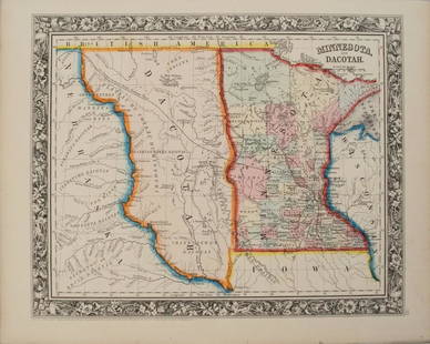
Sold20201860 Mitchell Map of Minnesota and the DakotasTitle/Content of Map: 1860 Mitchell Map of Minnesota and the Dakotas --Minnesota and Dacotah Date: 1860, Philadelphia Cartographer: S Mitchell Size: 10.6 X 13.3 in. This is a rather nice map of MinnesSee Sold Price
Sold2022County Map of Minnesota from S. A. Mitchell, Jr. (1874)Fully hand colored map of Minnesota divided into counties. Towns, capitols, roads, rivers, lakes, railroads, and proposed railroads are labeled. A wagon road from Fort Ridgely westward toward the MissSee Sold Price
Sold2017Hardesty: Map of Oregon, 1883Map: Oregon Maker: Hardesty 1883 21 x 14.75 in Please note that this lot has a confidential reserve. When you leave a bid in advance of the auction, submit your maximum. Jasper52 will bid on your behaSee Sold Price
Sold20191938 R Taylor White Pictorial Map of Minnesota --Title: 1938 R Taylor White Pictorial Map of Minnesota -- Minnesota Date: 1938, Boston Cartographer: Ruth Taylor White Size: 11.6 x 8.5 in. Additional Information: This is Ruth Taylor White's charmingSee Sold Price
Sold2017Colton: Antique Map of Minnesota, 1867Huge 1867 Minnesota map by Colton. Very fine example of this early large format map. Finely engraved map of the state with inset of the north-eastern portion at upper right. Highly detailed with identSee Sold Price
Sold2017Colton: Antique Map of Minnesota, 1855Extremely clean 1855 Colton map of Minnesota. From the 1856 edition of Colton’s Atlas of the World. A virtually spotless map. Lovely full hand-color and impression. Two tiny, light margin spotsSee Sold Price
May 29Cedarburg Auction & Appraisals LLCSet of Four Maps Showing All of Spain and Portugal$375(2 bids)
Jun 07Freeman's | Hindman[MAP]. TODESCHI, Pietro. [Nova et Acurata Totius Americae Tabula auct. G.I. Blaeu] America quarta$5,000
May 29Cedarburg Auction & Appraisals LLCRare 1877 Double sided map of Milwaukee and Wisconsin$40(4 bids)
10 hrs LeftClark's Fine Art & Auctioneers Inc.Val A. Samuelson (1913-2000) Minnesota California$25(2 bids)
Jun 07Freeman's | Hindman[MAP]. ORTELIUS, Abraham. Americae Sive Novi Orbis, Nova Descriptio. 1573.$1,000(1 bid)


![[MAP]. TODESCHI, Pietro. [Nova et Acurata Totius Americae Tabula auct. G.I. Blaeu] America quarta (1 of 1)](https://p1.liveauctioneers.com/197/329395/177650542_1_x.jpg?height=282&quality=70&version=1715364962)


![[MAPS]. A group of 3 engraved maps, most with hand-coloring. (1 of 4)](https://p1.liveauctioneers.com/197/328642/177014805_1_x.jpg?height=282&quality=70&version=1714760103)
![[MAP]. ORTELIUS, Abraham. Americae Sive Novi Orbis, Nova Descriptio. 1573. (1 of 2)](https://p1.liveauctioneers.com/197/329395/177650534_1_x.jpg?height=282&quality=70&version=1715364962)